Paradise Topo Map Kentucky
To zoom in, hover over the map of Paradise
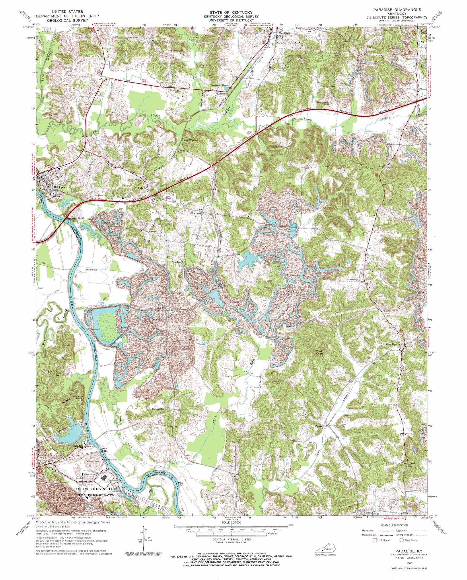
USGS Topo Quad 37086c8 - 1:24,000 scale
| Topo Map Name: | Paradise |
| USGS Topo Quad ID: | 37086c8 |
| Print Size: | ca. 21 1/4" wide x 27" high |
| Southeast Coordinates: | 37.25° N latitude / 86.875° W longitude |
| Map Center Coordinates: | 37.3125° N latitude / 86.9375° W longitude |
| U.S. State: | KY |
| Filename: | o37086c8.jpg |
| Download Map JPG Image: | Paradise topo map 1:24,000 scale |
| Map Type: | Topographic |
| Topo Series: | 7.5´ |
| Map Scale: | 1:24,000 |
| Source of Map Images: | United States Geological Survey (USGS) |
| Alternate Map Versions: |
Paradise KY 1954, updated 1955 Download PDF Buy paper map Paradise KY 1963, updated 1964 Download PDF Buy paper map Paradise KY 1963, updated 1973 Download PDF Buy paper map Paradise KY 2010 Download PDF Buy paper map Paradise KY 2013 Download PDF Buy paper map Paradise KY 2016 Download PDF Buy paper map |
1:24,000 Topo Quads surrounding Paradise
Glenville |
Utica |
Pleasant Ridge |
Dundee |
Olaton |
Livermore |
Equality |
Hartford |
Horton |
Rosine |
Central City West |
Central City East |
Paradise |
Cromwell |
Flener |
Greenville |
Drakesboro |
Rochester |
South Hill |
Morgantown |
Kirkmansville |
Rosewood |
Dunmor |
Quality |
Sugar Grove |
> Back to 37086a1 at 1:100,000 scale
> Back to 37086a1 at 1:250,000 scale
> Back to U.S. Topo Maps home
Paradise topo map: Gazetteer
Paradise: Cliffs
Jackson Bluff elevation 117m 383′Paradise: Populated Places
Cool Springs elevation 168m 551′Echols elevation 162m 531′
Ken Wye elevation 122m 400′
Nineteen elevation 142m 465′
Paradise elevation 122m 400′
Rockport elevation 133m 436′
Scottown elevation 168m 551′
Simmons elevation 135m 442′
Wysox elevation 122m 400′
Paradise: Streams
Jacobs Creek elevation 115m 377′Pond Creek elevation 110m 360′
Pond Run elevation 117m 383′
Pond Run elevation 112m 367′
Render Creek elevation 117m 383′
Southards Creek elevation 117m 383′
Paradise: Summits
Airdrie Hill elevation 165m 541′Pilot Knob elevation 188m 616′
Paradise digital topo map on disk
Buy this Paradise topo map showing relief, roads, GPS coordinates and other geographical features, as a high-resolution digital map file on DVD: