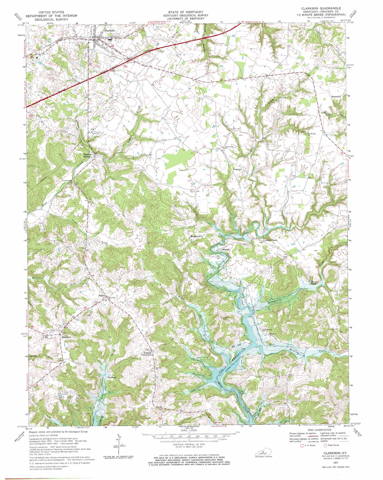
Clarkson Topo Map Kentucky
To zoom in, hover over the map of Clarkson
USGS Topo Quad 37086d2 - 1:24,000 scale
| Topo Map Name: | Clarkson |
| USGS Topo Quad ID: | 37086d2 |
| Print Size: | ca. 21 1/4" wide x 27" high |
| Southeast Coordinates: | 37.375° N latitude / 86.125° W longitude |
| Map Center Coordinates: | 37.4375° N latitude / 86.1875° W longitude |
| U.S. State: | KY |
| Filename: | o37086d2.jpg |
| Download Map JPG Image: | Clarkson topo map 1:24,000 scale |
| Map Type: | Topographic |
| Topo Series: | 7.5´ |
| Map Scale: | 1:24,000 |
| Source of Map Images: | United States Geological Survey (USGS) |
| Alternate Map Versions: |
Clarkson KY 1954, updated 1955 Download PDF Buy paper map Clarkson KY 1967, updated 1969 Download PDF Buy paper map Clarkson KY 2010 Download PDF Buy paper map Clarkson KY 2013 Download PDF Buy paper map Clarkson KY 2016 Download PDF Buy paper map |
1:24,000 Topo Quads surrounding Clarkson
Kingswood |
Custer |
Constantine |
Howe Valley |
Cecilia |
Mcdaniels |
Madrid |
Big Clifty |
Summit |
Sonora |
Caneyville |
Leitchfield |
Clarkson |
Millerstown |
Upton |
Ready |
Bee Spring |
Nolin Lake |
Cub Run |
Munfordville |
Reedyville |
Brownsville |
Rhoda |
Mammoth Cave |
Horse Cave |
> Back to 37086a1 at 1:100,000 scale
> Back to 37086a1 at 1:250,000 scale
> Back to U.S. Topo Maps home
Clarkson topo map: Gazetteer
Clarkson: Populated Places
Black Rock elevation 175m 574′Clarkson elevation 222m 728′
Fragrant elevation 202m 662′
Grayson Springs elevation 170m 557′
Higdon elevation 170m 557′
Horntown elevation 227m 744′
Huffman elevation 178m 583′
Johnson Crossroads elevation 238m 780′
Meredith elevation 250m 820′
Peonia elevation 238m 780′
Rock Creek elevation 196m 643′
Skaggstown elevation 184m 603′
Snap elevation 179m 587′
Clarkson: Streams
Cedar Lick elevation 159m 521′Grindstone Fork elevation 165m 541′
Hunting Fork elevation 158m 518′
Lizard Branch elevation 168m 551′
Pearson Branch elevation 157m 515′
Clarkson digital topo map on disk
Buy this Clarkson topo map showing relief, roads, GPS coordinates and other geographical features, as a high-resolution digital map file on DVD: