Big Clifty Topo Map Kentucky
To zoom in, hover over the map of Big Clifty
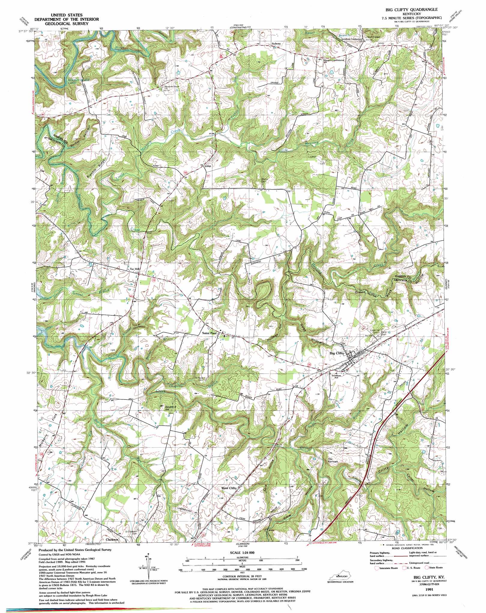
USGS Topo Quad 37086e2 - 1:24,000 scale
| Topo Map Name: | Big Clifty |
| USGS Topo Quad ID: | 37086e2 |
| Print Size: | ca. 21 1/4" wide x 27" high |
| Southeast Coordinates: | 37.5° N latitude / 86.125° W longitude |
| Map Center Coordinates: | 37.5625° N latitude / 86.1875° W longitude |
| U.S. State: | KY |
| Filename: | o37086e2.jpg |
| Download Map JPG Image: | Big Clifty topo map 1:24,000 scale |
| Map Type: | Topographic |
| Topo Series: | 7.5´ |
| Map Scale: | 1:24,000 |
| Source of Map Images: | United States Geological Survey (USGS) |
| Alternate Map Versions: |
Big Clifty KY 1949, updated 1952 Download PDF Buy paper map Big Clifty KY 1960, updated 1961 Download PDF Buy paper map Big Clifty KY 1972, updated 1973 Download PDF Buy paper map Big Clifty KY 1991, updated 1992 Download PDF Buy paper map Big Clifty KY 2010 Download PDF Buy paper map Big Clifty KY 2013 Download PDF Buy paper map Big Clifty KY 2016 Download PDF Buy paper map |
1:24,000 Topo Quads surrounding Big Clifty
Hardinsburg |
Garfield |
Big Spring |
Flaherty |
Vine Grove |
Kingswood |
Custer |
Constantine |
Howe Valley |
Cecilia |
Mcdaniels |
Madrid |
Big Clifty |
Summit |
Sonora |
Caneyville |
Leitchfield |
Clarkson |
Millerstown |
Upton |
Ready |
Bee Spring |
Nolin Lake |
Cub Run |
Munfordville |
> Back to 37086e1 at 1:100,000 scale
> Back to 37086a1 at 1:250,000 scale
> Back to U.S. Topo Maps home
Big Clifty topo map: Gazetteer
Big Clifty: Airports
McGrew Airport elevation 214m 702′Big Clifty: Gaps
The Narrows elevation 220m 721′Big Clifty: Populated Places
Big Clifty elevation 231m 757′Limp elevation 220m 721′
Saint Paul elevation 223m 731′
Solway elevation 237m 777′
Tar Hill elevation 219m 718′
West Clifty elevation 209m 685′
Big Clifty: Ridges
Ripshin Ridge elevation 210m 688′Big Clifty: Streams
Barton Run elevation 163m 534′Beaver Dam Creek elevation 158m 518′
Bozier Branch elevation 162m 531′
Chapells Branch elevation 160m 524′
Drane Branch elevation 162m 531′
Flutter Creek elevation 162m 531′
Grindstone Run elevation 168m 551′
Little Meeting Creek elevation 162m 531′
Petty Branch elevation 181m 593′
Sugar Branch elevation 170m 557′
Tinker Run elevation 178m 583′
Big Clifty: Summits
Double S Hill elevation 208m 682′Big Clifty: Valleys
Carter Hollow elevation 180m 590′Clifty Hollow elevation 176m 577′
Cold Hollow elevation 170m 557′
Crow Hollow elevation 173m 567′
Decker Hollow elevation 161m 528′
Green Rock Hollow elevation 180m 590′
Owen Hollow elevation 179m 587′
Portman Hollow elevation 176m 577′
Big Clifty digital topo map on disk
Buy this Big Clifty topo map showing relief, roads, GPS coordinates and other geographical features, as a high-resolution digital map file on DVD: