Madrid Topo Map Kentucky
To zoom in, hover over the map of Madrid
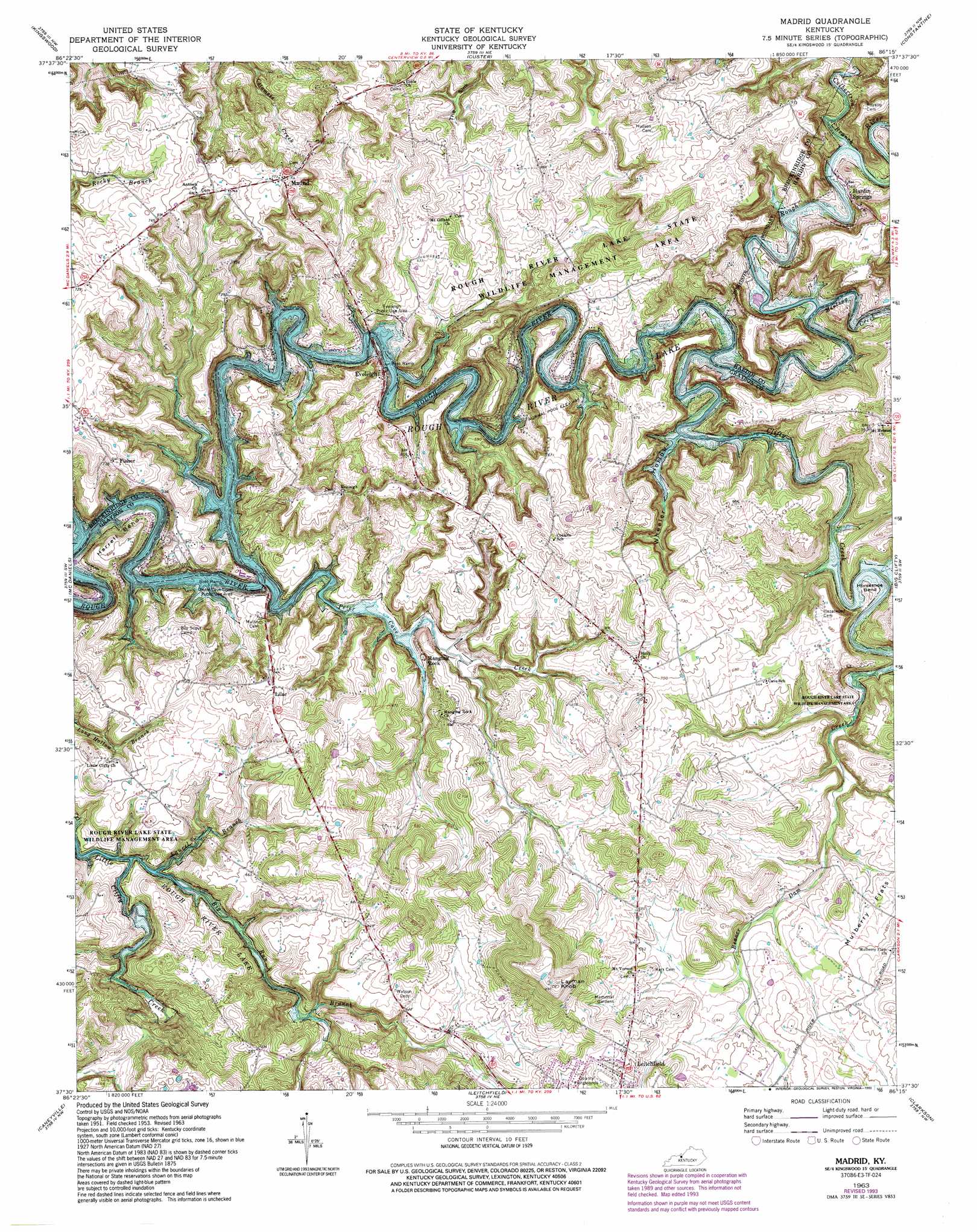
USGS Topo Quad 37086e3 - 1:24,000 scale
| Topo Map Name: | Madrid |
| USGS Topo Quad ID: | 37086e3 |
| Print Size: | ca. 21 1/4" wide x 27" high |
| Southeast Coordinates: | 37.5° N latitude / 86.25° W longitude |
| Map Center Coordinates: | 37.5625° N latitude / 86.3125° W longitude |
| U.S. State: | KY |
| Filename: | o37086e3.jpg |
| Download Map JPG Image: | Madrid topo map 1:24,000 scale |
| Map Type: | Topographic |
| Topo Series: | 7.5´ |
| Map Scale: | 1:24,000 |
| Source of Map Images: | United States Geological Survey (USGS) |
| Alternate Map Versions: |
Madrid KY 1963, updated 1976 Download PDF Buy paper map Madrid KY 1963, updated 1993 Download PDF Buy paper map Madrid KY 2010 Download PDF Buy paper map Madrid KY 2013 Download PDF Buy paper map Madrid KY 2016 Download PDF Buy paper map |
1:24,000 Topo Quads surrounding Madrid
Mattingly |
Hardinsburg |
Garfield |
Big Spring |
Flaherty |
Glen Dean |
Kingswood |
Custer |
Constantine |
Howe Valley |
Falls Of Rough |
Mcdaniels |
Madrid |
Big Clifty |
Summit |
Spring Lick |
Caneyville |
Leitchfield |
Clarkson |
Millerstown |
Welchs Creek |
Ready |
Bee Spring |
Nolin Lake |
Cub Run |
> Back to 37086e1 at 1:100,000 scale
> Back to 37086a1 at 1:250,000 scale
> Back to U.S. Topo Maps home
Madrid topo map: Gazetteer
Madrid: Basins
The Sink elevation 208m 682′Madrid: Bends
Harrell Bend elevation 176m 577′Horseshoe Bend elevation 161m 528′
Madrid: Flats
Mulberry Flats elevation 192m 629′Madrid: Populated Places
Eveleigh elevation 163m 534′Fisher elevation 220m 721′
Hanging Rock elevation 162m 531′
Hardin Springs elevation 164m 538′
Lilac elevation 198m 649′
Madrid elevation 223m 731′
Madrid: Streams
Big Run Branch elevation 152m 498′Clifty Creek elevation 169m 554′
Culbertson Branch elevation 169m 554′
Johnson School Branch elevation 171m 561′
Laurel Branch elevation 165m 541′
Meeting Creek elevation 151m 495′
Peter Cave Creek elevation 150m 492′
Madrid: Summits
Layman Knob elevation 275m 902′Madrid: Valleys
Wheeler Hollow elevation 156m 511′Madrid digital topo map on disk
Buy this Madrid topo map showing relief, roads, GPS coordinates and other geographical features, as a high-resolution digital map file on DVD: