Pleasant Ridge Topo Map Kentucky
To zoom in, hover over the map of Pleasant Ridge
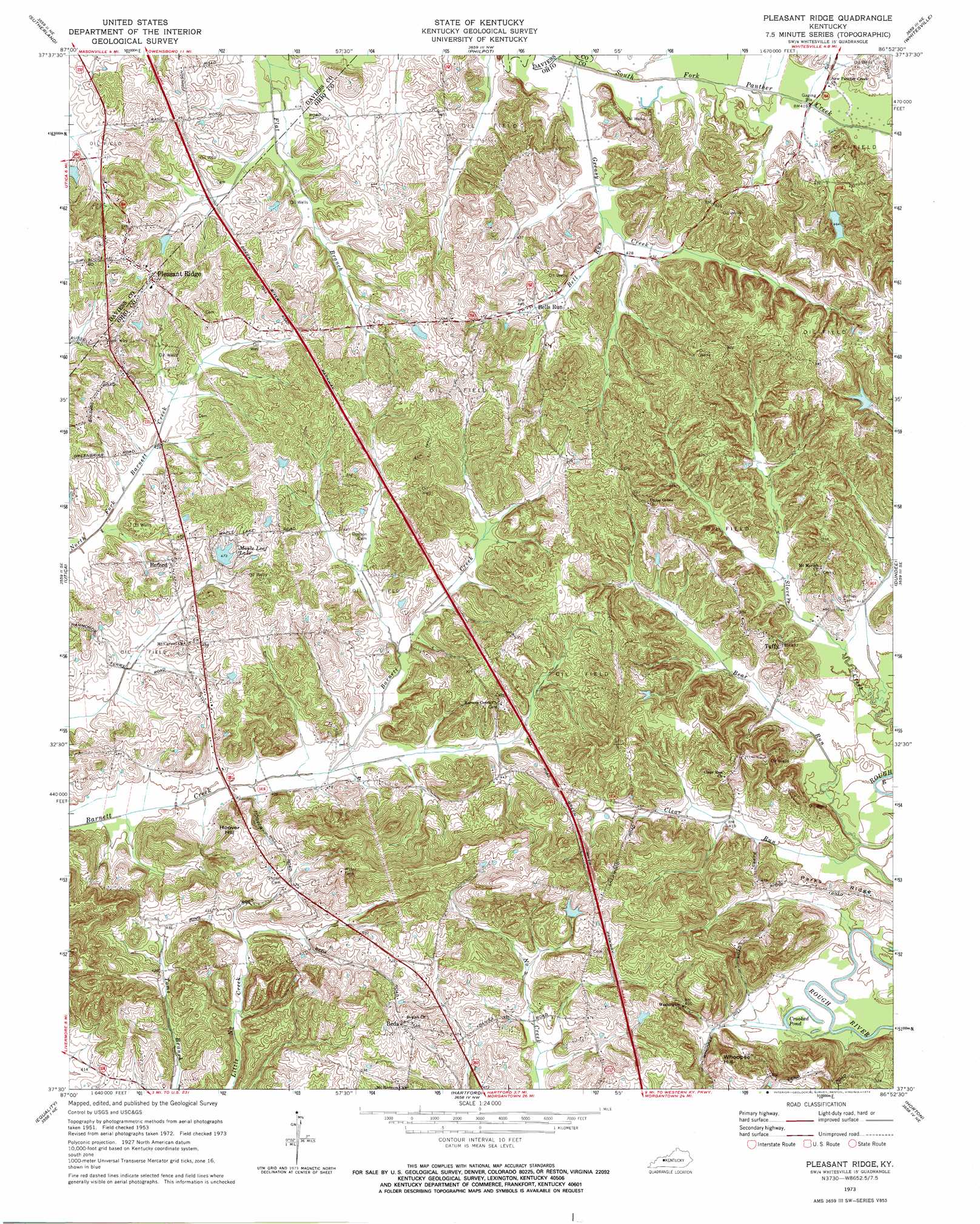
USGS Topo Quad 37086e8 - 1:24,000 scale
| Topo Map Name: | Pleasant Ridge |
| USGS Topo Quad ID: | 37086e8 |
| Print Size: | ca. 21 1/4" wide x 27" high |
| Southeast Coordinates: | 37.5° N latitude / 86.875° W longitude |
| Map Center Coordinates: | 37.5625° N latitude / 86.9375° W longitude |
| U.S. State: | KY |
| Filename: | o37086e8.jpg |
| Download Map JPG Image: | Pleasant Ridge topo map 1:24,000 scale |
| Map Type: | Topographic |
| Topo Series: | 7.5´ |
| Map Scale: | 1:24,000 |
| Source of Map Images: | United States Geological Survey (USGS) |
| Alternate Map Versions: |
Pleasant Ridge KY 1953, updated 1955 Download PDF Buy paper map Pleasant Ridge KY 1973, updated 1974 Download PDF Buy paper map Pleasant Ridge KY 2010 Download PDF Buy paper map Pleasant Ridge KY 2013 Download PDF Buy paper map Pleasant Ridge KY 2016 Download PDF Buy paper map |
1:24,000 Topo Quads surrounding Pleasant Ridge
Owensboro West |
Owensboro East |
Maceo |
Pellville |
Cloverport |
Panther |
Sutherland |
Philpot |
Whitesville |
Fordsville |
Glenville |
Utica |
Pleasant Ridge |
Dundee |
Olaton |
Livermore |
Equality |
Hartford |
Horton |
Rosine |
Central City West |
Central City East |
Paradise |
Cromwell |
Flener |
> Back to 37086e1 at 1:100,000 scale
> Back to 37086a1 at 1:250,000 scale
> Back to U.S. Topo Maps home
Pleasant Ridge topo map: Gazetteer
Pleasant Ridge: Lakes
Crooked Pond elevation 119m 390′Pleasant Ridge: Populated Places
Beda elevation 166m 544′Bells Run elevation 132m 433′
Buford elevation 147m 482′
Pleasant Ridge elevation 159m 521′
Taffy elevation 148m 485′
Pleasant Ridge: Reservoirs
Maple Leaf Lake elevation 141m 462′Pleasant Ridge: Ridges
Parks Ridge elevation 136m 446′Pleasant Ridge: Streams
Bear Run elevation 119m 390′Bell Run elevation 127m 416′
Deserter Creek elevation 125m 410′
Dry Creek elevation 152m 498′
Greasy Creek elevation 125m 410′
Pleasant Ridge: Summits
Hoover Hill elevation 166m 544′Whoopee Hill elevation 183m 600′
Pleasant Ridge digital topo map on disk
Buy this Pleasant Ridge topo map showing relief, roads, GPS coordinates and other geographical features, as a high-resolution digital map file on DVD: