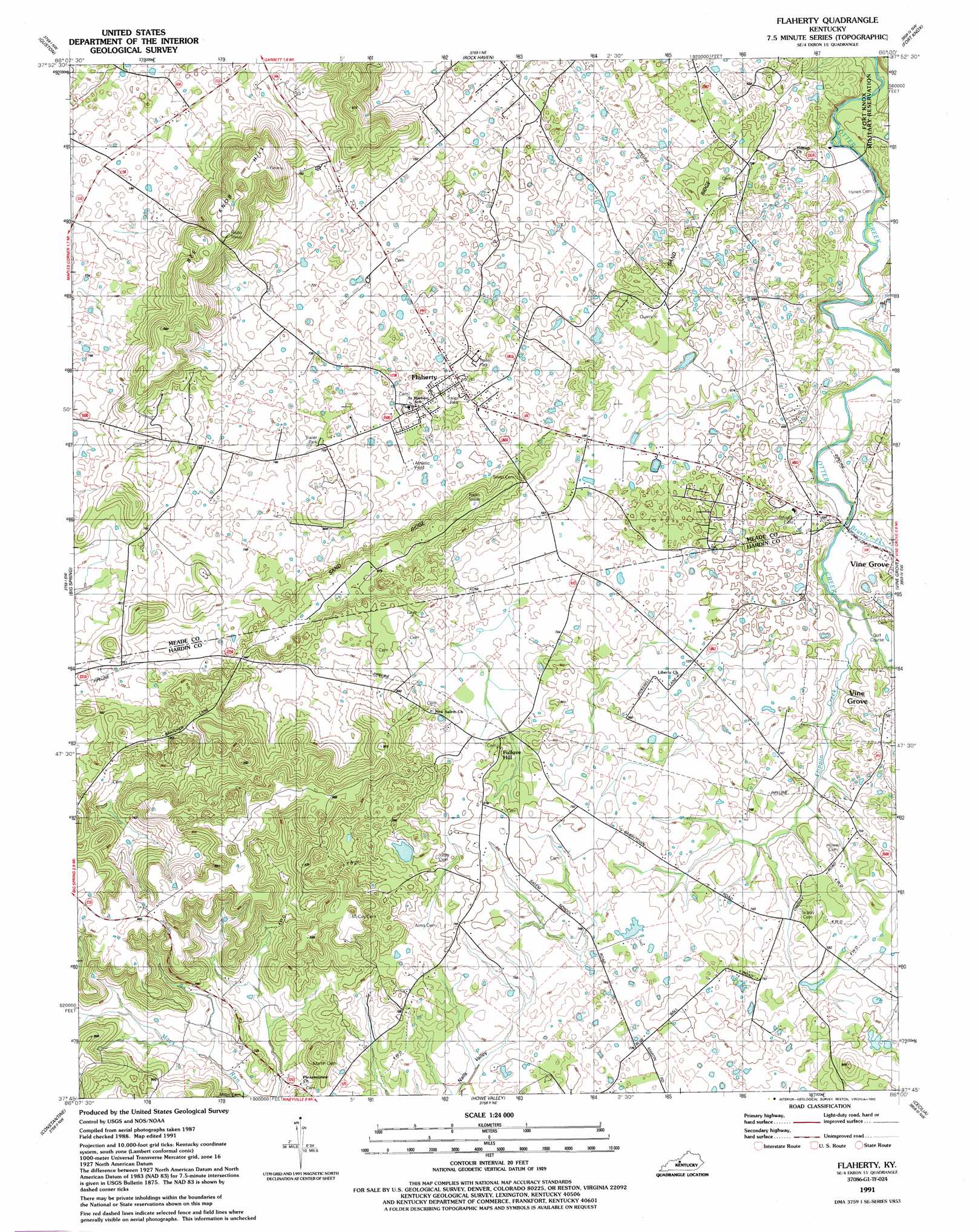
Flaherty Topo Map Kentucky
To zoom in, hover over the map of Flaherty
USGS Topo Quad 37086g1 - 1:24,000 scale
| Topo Map Name: | Flaherty |
| USGS Topo Quad ID: | 37086g1 |
| Print Size: | ca. 21 1/4" wide x 27" high |
| Southeast Coordinates: | 37.75° N latitude / 86° W longitude |
| Map Center Coordinates: | 37.8125° N latitude / 86.0625° W longitude |
| U.S. State: | KY |
| Filename: | o37086g1.jpg |
| Download Map JPG Image: | Flaherty topo map 1:24,000 scale |
| Map Type: | Topographic |
| Topo Series: | 7.5´ |
| Map Scale: | 1:24,000 |
| Source of Map Images: | United States Geological Survey (USGS) |
| Alternate Map Versions: |
Flaherty KY 1948 Download PDF Buy paper map Flaherty KY 1960, updated 1961 Download PDF Buy paper map Flaherty KY 1960, updated 1968 Download PDF Buy paper map Flaherty KY 1960, updated 1983 Download PDF Buy paper map Flaherty KY 1991, updated 1992 Download PDF Buy paper map Flaherty KY 2010 Download PDF Buy paper map Flaherty KY 2013 Download PDF Buy paper map Flaherty KY 2016 Download PDF Buy paper map |
1:24,000 Topo Quads surrounding Flaherty
New Amsterdam |
Mauckport |
Laconia |
Kosmosdale |
Valley Station |
Irvington |
Guston |
Rock Haven |
Fort Knox |
Pitts Point |
Garfield |
Big Spring |
Flaherty |
Vine Grove |
Colesburg |
Custer |
Constantine |
Howe Valley |
Cecilia |
Elizabethtown |
Madrid |
Big Clifty |
Summit |
Sonora |
Tonieville |
> Back to 37086e1 at 1:100,000 scale
> Back to 37086a1 at 1:250,000 scale
> Back to U.S. Topo Maps home
Flaherty topo map: Gazetteer
Flaherty: Populated Places
Flaherty elevation 237m 777′Flaherty: Ridges
Sand Ridge elevation 244m 800′Flaherty: Streams
Brushy Fork elevation 189m 620′Flippin Creek elevation 195m 639′
Flaherty: Summits
Bee Knob Hill elevation 306m 1003′Fullove Hill elevation 246m 807′
Flaherty digital topo map on disk
Buy this Flaherty topo map showing relief, roads, GPS coordinates and other geographical features, as a high-resolution digital map file on DVD: