Cannelton Topo Map Indiana
To zoom in, hover over the map of Cannelton
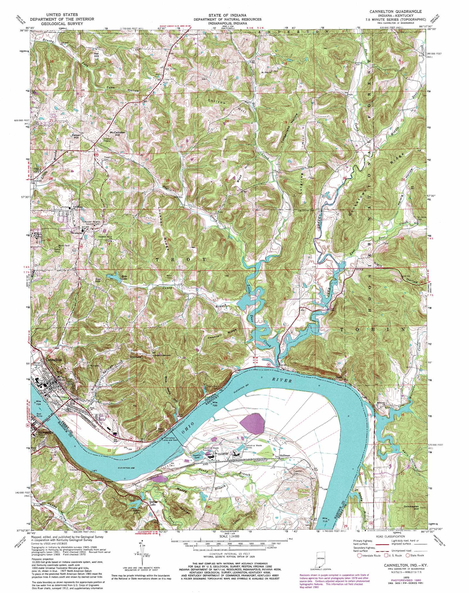
USGS Topo Quad 37086h6 - 1:24,000 scale
| Topo Map Name: | Cannelton |
| USGS Topo Quad ID: | 37086h6 |
| Print Size: | ca. 21 1/4" wide x 27" high |
| Southeast Coordinates: | 37.875° N latitude / 86.625° W longitude |
| Map Center Coordinates: | 37.9375° N latitude / 86.6875° W longitude |
| U.S. States: | IN, KY |
| Filename: | o37086h6.jpg |
| Download Map JPG Image: | Cannelton topo map 1:24,000 scale |
| Map Type: | Topographic |
| Topo Series: | 7.5´ |
| Map Scale: | 1:24,000 |
| Source of Map Images: | United States Geological Survey (USGS) |
| Alternate Map Versions: |
Cannelton IN 1949 Download PDF Buy paper map Cannelton IN 1953, updated 1954 Download PDF Buy paper map Cannelton IN 1953, updated 1964 Download PDF Buy paper map Cannelton IN 1970, updated 1972 Download PDF Buy paper map Cannelton IN 1970, updated 1981 Download PDF Buy paper map Cannelton IN 1993, updated 1996 Download PDF Buy paper map Cannelton IN 2011 Download PDF Buy paper map Cannelton IN 2013 Download PDF Buy paper map Cannelton IN 2016 Download PDF Buy paper map |
| FStopo: | US Forest Service topo Cannelton is available: Download FStopo PDF Download FStopo TIF |
1:24,000 Topo Quads surrounding Cannelton
Dale |
Saint Meinrad |
Bristow |
Branchville |
Beechwood |
Santa Claus |
Fulda |
Gatchel |
Derby |
Alton |
Lewisport |
Tell City |
Cannelton |
Rome |
Lodiburg |
Maceo |
Pellville |
Cloverport |
Mattingly |
Hardinsburg |
Philpot |
Whitesville |
Fordsville |
Glen Dean |
Kingswood |
> Back to 37086e1 at 1:100,000 scale
> Back to 37086a1 at 1:250,000 scale
> Back to U.S. Topo Maps home
Cannelton topo map: Gazetteer
Cannelton: Bridges
Lincoln Toll Road Bridge elevation 107m 351′Lincoln Trail Bridge elevation 107m 351′
Cannelton: Cliffs
Jeffry Cliff elevation 209m 685′Cannelton: Dams
Cannelton Locks and Dam elevation 123m 403′Cannelton Locks and Dam elevation 116m 380′
Echo Valley Lake Dam elevation 147m 482′
Cannelton: Lakes
Lost Lake Pond elevation 177m 580′Cannelton: Parks
Camp Koch elevation 145m 475′Cannelton: Populated Places
Cannelton elevation 125m 410′Dodd elevation 129m 423′
Skillman elevation 125m 410′
Cannelton: Post Offices
Rock Island Post Office (historical) elevation 128m 419′Cannelton: Reservoirs
Echo Valley Lake elevation 138m 452′Helwig Hollow Pond elevation 133m 436′
Indian Lake elevation 123m 403′
Timberlake Pond elevation 183m 600′
Cannelton: Ridges
Coontail Ridge elevation 180m 590′Goosetown Ridge elevation 224m 734′
Lockner Ridge elevation 194m 636′
Cannelton: Streams
Caney Branch elevation 117m 383′Deer Creek elevation 116m 380′
East Deer Creek elevation 118m 387′
Indian Creek elevation 109m 357′
Little Deer Creek elevation 116m 380′
Middle Deer Creek elevation 119m 390′
Miller Branch elevation 127m 416′
Millstone Creek elevation 116m 380′
Muddy Branch elevation 113m 370′
Murmer Creek elevation 127m 416′
Neglie Creek elevation 117m 383′
Sandy Branch elevation 116m 380′
Sandy Branch elevation 112m 367′
Cannelton: Summits
Boyd Hill elevation 188m 616′Chilton Hill elevation 195m 639′
Cox Hill elevation 189m 620′
Drinkwater Hill elevation 229m 751′
Ikel Hill elevation 177m 580′
Keiser Hill elevation 183m 600′
Lutgring Hill elevation 209m 685′
McCallister Hill elevation 183m 600′
Shafer Hill elevation 147m 482′
Cannelton: Valleys
Blue Wells Hollow elevation 125m 410′Brushy Hollow elevation 119m 390′
Funk Hollow elevation 136m 446′
Helwig Hollow elevation 121m 396′
Kelly Hollow elevation 119m 390′
Klein Hollow elevation 121m 396′
Sulphur Springs Hollow elevation 130m 426′
Timberlake Hollow elevation 132m 433′
Cannelton digital topo map on disk
Buy this Cannelton topo map showing relief, roads, GPS coordinates and other geographical features, as a high-resolution digital map file on DVD: