Tell City Topo Map Kentucky
To zoom in, hover over the map of Tell City
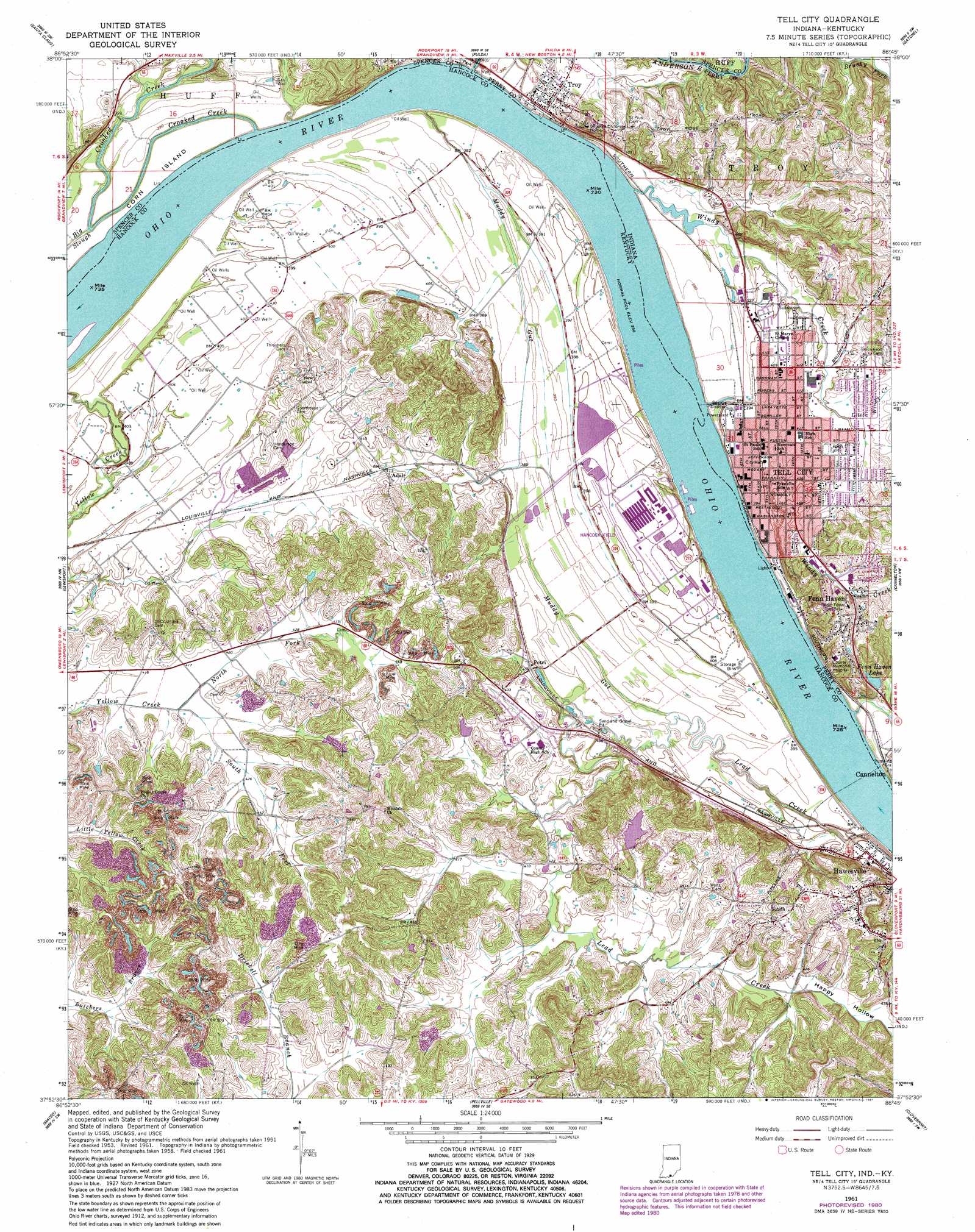
USGS Topo Quad 37086h7 - 1:24,000 scale
| Topo Map Name: | Tell City |
| USGS Topo Quad ID: | 37086h7 |
| Print Size: | ca. 21 1/4" wide x 27" high |
| Southeast Coordinates: | 37.875° N latitude / 86.75° W longitude |
| Map Center Coordinates: | 37.9375° N latitude / 86.8125° W longitude |
| U.S. States: | KY, IN |
| Filename: | o37086h7.jpg |
| Download Map JPG Image: | Tell City topo map 1:24,000 scale |
| Map Type: | Topographic |
| Topo Series: | 7.5´ |
| Map Scale: | 1:24,000 |
| Source of Map Images: | United States Geological Survey (USGS) |
| Alternate Map Versions: |
Tell City IN 1953, updated 1955 Download PDF Buy paper map Tell City IN 1953, updated 1955 Download PDF Buy paper map Tell City IN 1961, updated 1963 Download PDF Buy paper map Tell City IN 1961, updated 1963 Download PDF Buy paper map Tell City IN 1961, updated 1972 Download PDF Buy paper map Tell City IN 1961, updated 1981 Download PDF Buy paper map Tell City IN 2010 Download PDF Buy paper map Tell City IN 2013 Download PDF Buy paper map Tell City IN 2016 Download PDF Buy paper map |
1:24,000 Topo Quads surrounding Tell City
Holland |
Dale |
Saint Meinrad |
Bristow |
Branchville |
Chrisney |
Santa Claus |
Fulda |
Gatchel |
Derby |
Rockport |
Lewisport |
Tell City |
Cannelton |
Rome |
Owensboro East |
Maceo |
Pellville |
Cloverport |
Mattingly |
Sutherland |
Philpot |
Whitesville |
Fordsville |
Glen Dean |
> Back to 37086e1 at 1:100,000 scale
> Back to 37086a1 at 1:250,000 scale
> Back to U.S. Topo Maps home
Tell City topo map: Gazetteer
Tell City: Airports
Hancock Airfield elevation 122m 400′Tell City: Guts
Muddy Gut elevation 107m 351′Tell City: Parks
Legion Field elevation 126m 413′Tell City: Populated Places
Adair elevation 125m 410′Fenn Haven elevation 149m 488′
Hawesville elevation 158m 518′
Petri elevation 124m 406′
Tell City elevation 128m 419′
Troy elevation 144m 472′
Tell City: Reservoirs
Fenn Haven Lake elevation 123m 403′Tell City: Streams
Anderson River elevation 119m 390′Crooked Creek elevation 107m 351′
Lead Creek elevation 109m 357′
Little Windy Creek elevation 123m 403′
Muddy Gut elevation 116m 380′
North Yellow Creek Fork elevation 125m 410′
South Yellow Creek Fork elevation 125m 410′
Windy Creek elevation 116m 380′
Tell City: Valleys
Happy Hollow elevation 128m 419′Tell City digital topo map on disk
Buy this Tell City topo map showing relief, roads, GPS coordinates and other geographical features, as a high-resolution digital map file on DVD: