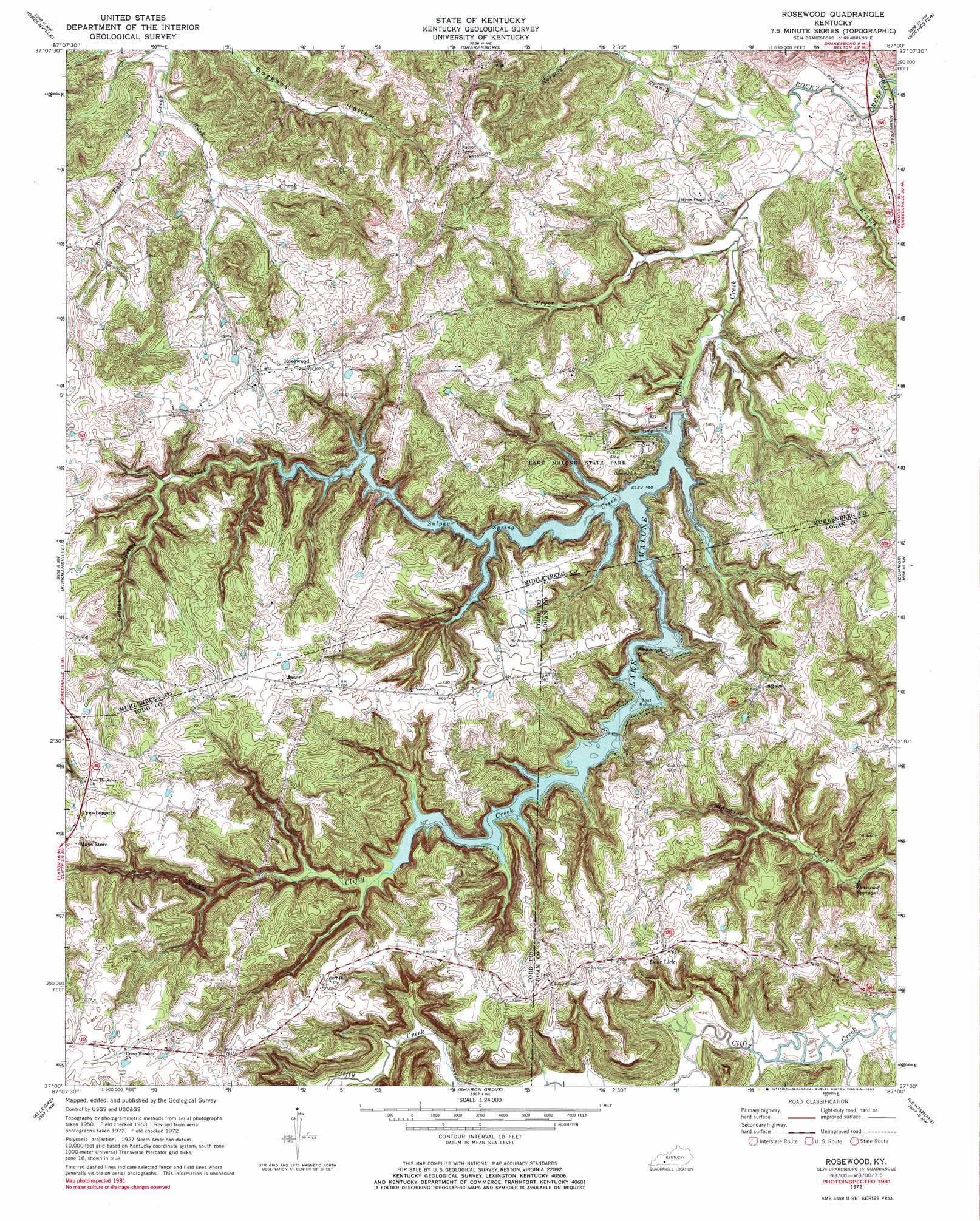
Rosewood Topo Map Kentucky
To zoom in, hover over the map of Rosewood
USGS Topo Quad 37087a1 - 1:24,000 scale
| Topo Map Name: | Rosewood |
| USGS Topo Quad ID: | 37087a1 |
| Print Size: | ca. 21 1/4" wide x 27" high |
| Southeast Coordinates: | 37° N latitude / 87° W longitude |
| Map Center Coordinates: | 37.0625° N latitude / 87.0625° W longitude |
| U.S. State: | KY |
| Filename: | o37087a1.jpg |
| Download Map JPG Image: | Rosewood topo map 1:24,000 scale |
| Map Type: | Topographic |
| Topo Series: | 7.5´ |
| Map Scale: | 1:24,000 |
| Source of Map Images: | United States Geological Survey (USGS) |
| Alternate Map Versions: |
Rosewood KY 1953, updated 1954 Download PDF Buy paper map Rosewood KY 1972, updated 1974 Download PDF Buy paper map Rosewood KY 2010 Download PDF Buy paper map Rosewood KY 2013 Download PDF Buy paper map Rosewood KY 2016 Download PDF Buy paper map |
1:24,000 Topo Quads surrounding Rosewood
Millport |
Central City West |
Central City East |
Paradise |
Cromwell |
Graham |
Greenville |
Drakesboro |
Rochester |
South Hill |
Haleys Mill |
Kirkmansville |
Rosewood |
Dunmor |
Quality |
Honey Grove |
Allegre |
Sharon Grove |
Lewisburg |
Homer |
Pembroke |
Elkton |
Olmstead |
Russellville |
Dennis |
> Back to 37087a1 at 1:100,000 scale
> Back to 37086a1 at 1:250,000 scale
> Back to U.S. Topo Maps home
Rosewood topo map: Gazetteer
Rosewood: Airports
Caring Wings Airport elevation 198m 649′Rosewood: Bays
Whiskey Bay elevation 137m 449′Rosewood: Cliffs
Whiterock Cliff elevation 137m 449′Rosewood: Parks
Lake Malone State Park elevation 171m 561′Rosewood: Populated Places
Agnes elevation 179m 587′Deer Lick elevation 209m 685′
Jason elevation 213m 698′
Rosewood elevation 183m 600′
Tyewhoppety elevation 215m 705′
Whiskey Bay elevation 139m 456′
Rosewood: Reservoirs
Lake Malone elevation 137m 449′Rosewood: Springs
Diamond Springs elevation 143m 469′Rosewood: Streams
Buck Creek elevation 133m 436′Lazy Branch elevation 125m 410′
Norman Branch elevation 124m 406′
Pryor Creek elevation 125m 410′
Rocky Clifty Creek elevation 137m 449′
Sulphur Spring Creek elevation 137m 449′
Rosewood digital topo map on disk
Buy this Rosewood topo map showing relief, roads, GPS coordinates and other geographical features, as a high-resolution digital map file on DVD: