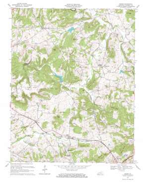
Crider Topo Map Kentucky
To zoom in, hover over the map of Crider
USGS Topo Quad 37087b8 - 1:24,000 scale
| Topo Map Name: | Crider |
| USGS Topo Quad ID: | 37087b8 |
| Print Size: | ca. 21 1/4" wide x 27" high |
| Southeast Coordinates: | 37.125° N latitude / 87.875° W longitude |
| Map Center Coordinates: | 37.1875° N latitude / 87.9375° W longitude |
| U.S. State: | KY |
| Filename: | o37087b8.jpg |
| Download Map JPG Image: | Crider topo map 1:24,000 scale |
| Map Type: | Topographic |
| Topo Series: | 7.5´ |
| Map Scale: | 1:24,000 |
| Source of Map Images: | United States Geological Survey (USGS) |
| Alternate Map Versions: |
Crider KY 1954, updated 1955 Download PDF Buy paper map Crider KY 1967, updated 1969 Download PDF Buy paper map Crider KY 2010 Download PDF Buy paper map Crider KY 2013 Download PDF Buy paper map Crider KY 2016 Download PDF Buy paper map |
1:24,000 Topo Quads surrounding Crider
> Back to 37087a1 at 1:100,000 scale
> Back to 37086a1 at 1:250,000 scale
> Back to U.S. Topo Maps home
Crider topo map: Gazetteer
Crider: Bends
Tucker Bottoms elevation 125m 410′Crider: Bridges
Sons Bridge elevation 125m 410′Crider: Cliffs
Fort Bluff elevation 190m 623′Crider: Lakes
Rabbit Lake elevation 176m 577′Crider: Populated Places
Crider elevation 143m 469′Crowtown elevation 171m 561′
Farmersville elevation 150m 492′
Flat Rock elevation 156m 511′
Rufus elevation 132m 433′
White Sulphur elevation 153m 501′
Crider: Ridges
Black Sulphur Ridge elevation 188m 616′Briarfield Ridge elevation 153m 501′
Campbell Ridge elevation 203m 666′
Coleman Ridge elevation 196m 643′
Ditney Ridge elevation 165m 541′
Dotson Ridge elevation 180m 590′
Hickory Ridge elevation 195m 639′
Nelson Ridge elevation 200m 656′
O'Brion Ridge elevation 185m 606′
Crider: Springs
Dunn Spring elevation 144m 472′Good Spring elevation 160m 524′
White Sulphur Spring elevation 163m 534′
Crider: Streams
Black Creek elevation 128m 419′Blackburn Branch elevation 120m 393′
Briarfield Branch elevation 129m 423′
Buchanan Creek elevation 120m 393′
Caney Creek elevation 122m 400′
Goose Creek elevation 117m 383′
Hewlett Creek elevation 137m 449′
Kennedy Run elevation 128m 419′
O'Brion Branch elevation 124m 406′
Stephenson Branch elevation 118m 387′
Tinsley Creek elevation 145m 475′
White Sulphur Creek elevation 147m 482′
Crider: Summits
Asher Hill elevation 190m 623′Bright Hill elevation 201m 659′
Brown Hill elevation 185m 606′
Buffalo Hill elevation 155m 508′
Carner Hill elevation 211m 692′
Cedar Hill elevation 166m 544′
Cliff Hill elevation 168m 551′
Farmer Knob elevation 193m 633′
Green Hill elevation 169m 554′
Leech Hill elevation 164m 538′
McChesney Hill elevation 167m 547′
Mockingbird Hill elevation 188m 616′
Montgomery Hill elevation 188m 616′
Morse Hill elevation 175m 574′
Nelson Hill elevation 232m 761′
Peach Orchard Hill elevation 191m 626′
Rattlesnake Hill elevation 189m 620′
Riley Hill elevation 188m 616′
Sheridan Hill elevation 192m 629′
Sigler Hill elevation 143m 469′
The Knob elevation 205m 672′
Trayler Riley Hill elevation 168m 551′
Crider digital topo map on disk
Buy this Crider topo map showing relief, roads, GPS coordinates and other geographical features, as a high-resolution digital map file on DVD:


