Newburgh Topo Map Indiana
To zoom in, hover over the map of Newburgh
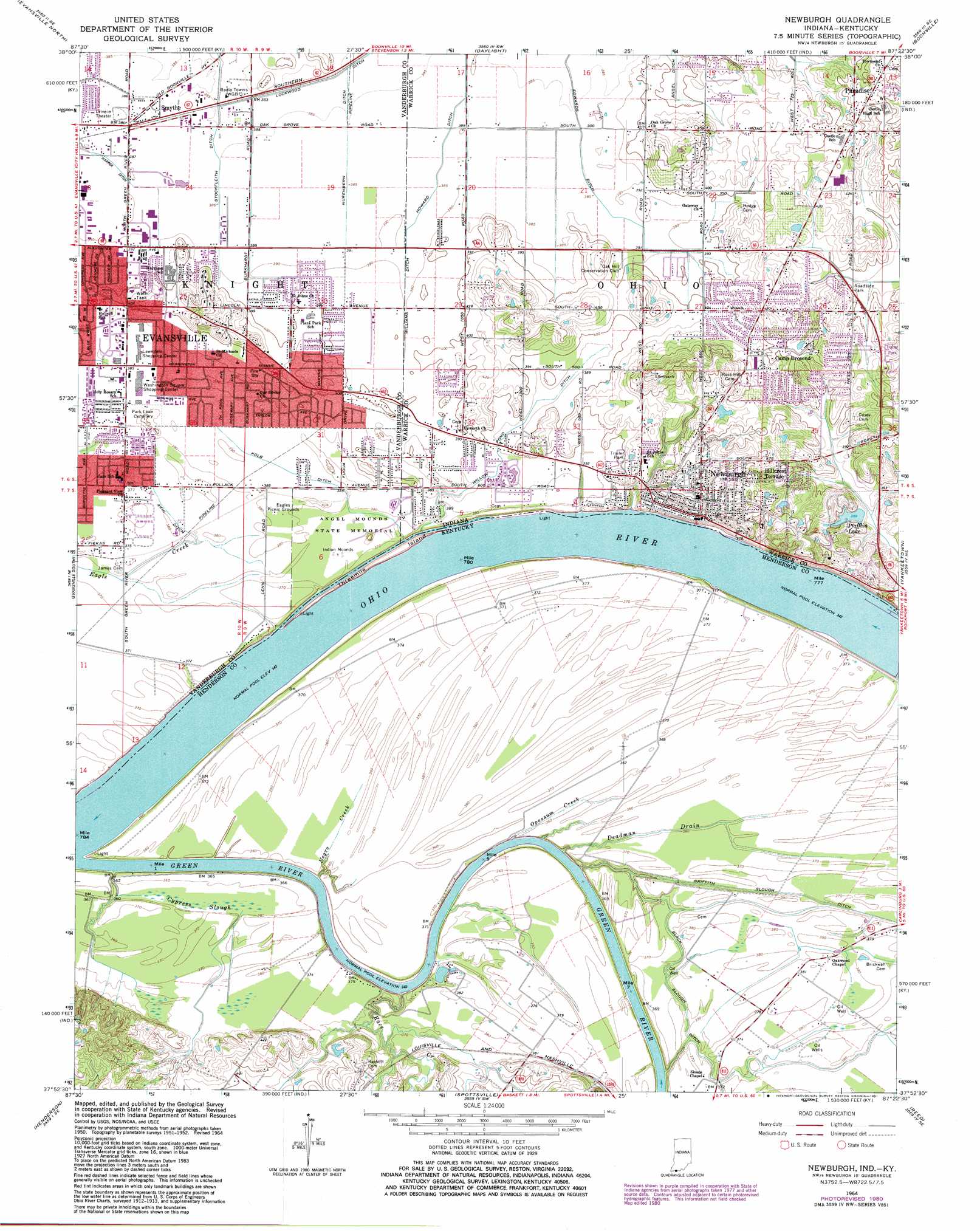
USGS Topo Quad 37087h4 - 1:24,000 scale
| Topo Map Name: | Newburgh |
| USGS Topo Quad ID: | 37087h4 |
| Print Size: | ca. 21 1/4" wide x 27" high |
| Southeast Coordinates: | 37.875° N latitude / 87.375° W longitude |
| Map Center Coordinates: | 37.9375° N latitude / 87.4375° W longitude |
| U.S. States: | IN, KY |
| Filename: | o37087h4.jpg |
| Download Map JPG Image: | Newburgh topo map 1:24,000 scale |
| Map Type: | Topographic |
| Topo Series: | 7.5´ |
| Map Scale: | 1:24,000 |
| Source of Map Images: | United States Geological Survey (USGS) |
| Alternate Map Versions: |
Newburgh IN 1952, updated 1953 Download PDF Buy paper map Newburgh IN 1964, updated 1966 Download PDF Buy paper map Newburgh IN 1964, updated 1981 Download PDF Buy paper map Newburgh IN 1964, updated 1981 Download PDF Buy paper map Newburgh IN 2010 Download PDF Buy paper map Newburgh IN 2013 Download PDF Buy paper map Newburgh IN 2016 Download PDF Buy paper map |
1:24,000 Topo Quads surrounding Newburgh
Cynthiana |
Haubstadt |
Elberfeld |
Lynnville |
Folsomville |
Kasson |
Evansville North |
Daylight |
Boonville |
De Gonia Springs |
West Franklin |
Evansville South |
Newburgh |
Yankeetown |
Richland City |
Wilson |
Henderson |
Spottsville |
Reed |
Owensboro West |
Poole |
Robards |
Delaware |
Curdsville |
Panther |
> Back to 37087e1 at 1:100,000 scale
> Back to 37086a1 at 1:250,000 scale
> Back to U.S. Topo Maps home
Newburgh topo map: Gazetteer
Newburgh: Canals
Akin Ditch elevation 115m 377′Black Slough Ditch elevation 110m 360′
Edwards Ditch elevation 117m 383′
Harper Ditch elevation 119m 390′
Kolb Ditch elevation 117m 383′
Lockwood Ditch elevation 119m 390′
Nurenbern Ditch elevation 119m 390′
South Willow Pond Ditch elevation 118m 387′
Stockfleith Ditch elevation 118m 387′
Williams Ditch elevation 119m 390′
Newburgh: Islands
Threemile Island elevation 104m 341′Newburgh: Parks
Angel Mounds State Memorial elevation 115m 377′Eagles Picnic Grounds elevation 116m 380′
Newburgh: Populated Places
Camp Brosend elevation 135m 442′Hillcrest Terrace elevation 132m 433′
Newburgh elevation 120m 393′
Paradise elevation 140m 459′
Smythe elevation 119m 390′
Newburgh: Reservoirs
Pfafflin Lake elevation 116m 380′Newburgh: Streams
Cypress Slough elevation 106m 347′Deadman Drain elevation 104m 341′
Green River elevation 104m 341′
Negro Creek elevation 104m 341′
Opossum Creek elevation 104m 341′
Race Creek elevation 106m 347′
Newburgh digital topo map on disk
Buy this Newburgh topo map showing relief, roads, GPS coordinates and other geographical features, as a high-resolution digital map file on DVD: