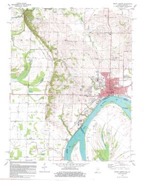
Mount Vernon Topo Map Indiana
To zoom in, hover over the map of Mount Vernon
USGS Topo Quad 37087h8 - 1:24,000 scale
| Topo Map Name: | Mount Vernon |
| USGS Topo Quad ID: | 37087h8 |
| Print Size: | ca. 21 1/4" wide x 27" high |
| Southeast Coordinates: | 37.875° N latitude / 87.875° W longitude |
| Map Center Coordinates: | 37.9375° N latitude / 87.9375° W longitude |
| U.S. States: | IN, KY |
| Filename: | o37087h8.jpg |
| Download Map JPG Image: | Mount Vernon topo map 1:24,000 scale |
| Map Type: | Topographic |
| Topo Series: | 7.5´ |
| Map Scale: | 1:24,000 |
| Source of Map Images: | United States Geological Survey (USGS) |
| Alternate Map Versions: |
Mount Vernon IN 1952, updated 1953 Download PDF Buy paper map Mount Vernon IN 1957, updated 1960 Download PDF Buy paper map Mount Vernon IN 1957, updated 1960 Download PDF Buy paper map Mount Vernon IN 1981, updated 1981 Download PDF Buy paper map Mount Vernon IN 2010 Download PDF Buy paper map Mount Vernon IN 2013 Download PDF Buy paper map Mount Vernon IN 2016 Download PDF Buy paper map |
1:24,000 Topo Quads surrounding Mount Vernon
> Back to 37087e1 at 1:100,000 scale
> Back to 37086a1 at 1:250,000 scale
> Back to U.S. Topo Maps home
Mount Vernon topo map: Gazetteer
Mount Vernon: Airports
Mount Vernon Municipal Airport elevation 115m 377′Parrish Airport elevation 120m 393′
Mount Vernon: Canals
Whipple Ditch elevation 110m 360′Mount Vernon: Cliffs
Brewery Hill elevation 152m 498′Mount Vernon: Guts
Grassy Slough elevation 110m 360′Mount Vernon: Islands
Towhead Island elevation 107m 351′Mount Vernon: Lakes
Grassy Pond elevation 107m 351′Pfister Pond elevation 128m 419′
Mount Vernon: Populated Places
Dead Mans Crossing elevation 128m 419′Erwin elevation 117m 383′
Farmersville elevation 128m 419′
Hovey elevation 113m 370′
Mount Vernon elevation 122m 400′
Prairie elevation 110m 360′
Upton elevation 116m 380′
Mount Vernon: Streams
Beaverdam Creek elevation 104m 341′Indian Creek elevation 111m 364′
McFadden Creek elevation 104m 341′
Pitcher Creek elevation 107m 351′
Smith Creek elevation 105m 344′
Mount Vernon digital topo map on disk
Buy this Mount Vernon topo map showing relief, roads, GPS coordinates and other geographical features, as a high-resolution digital map file on DVD:


