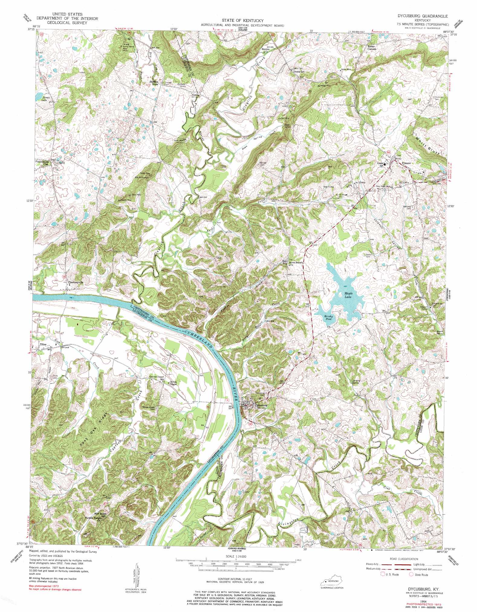
Dycusburg Topo Map Kentucky
To zoom in, hover over the map of Dycusburg
USGS Topo Quad 37088b2 - 1:24,000 scale
| Topo Map Name: | Dycusburg |
| USGS Topo Quad ID: | 37088b2 |
| Print Size: | ca. 21 1/4" wide x 27" high |
| Southeast Coordinates: | 37.125° N latitude / 88.125° W longitude |
| Map Center Coordinates: | 37.1875° N latitude / 88.1875° W longitude |
| U.S. State: | KY |
| Filename: | o37088b2.jpg |
| Download Map JPG Image: | Dycusburg topo map 1:24,000 scale |
| Map Type: | Topographic |
| Topo Series: | 7.5´ |
| Map Scale: | 1:24,000 |
| Source of Map Images: | United States Geological Survey (USGS) |
| Alternate Map Versions: |
Dycusburg KY 1954, updated 1955 Download PDF Buy paper map Dycusburg KY 1954, updated 1977 Download PDF Buy paper map Dycusburg KY 2010 Download PDF Buy paper map Dycusburg KY 2013 Download PDF Buy paper map Dycusburg KY 2016 Download PDF Buy paper map |
1:24,000 Topo Quads surrounding Dycusburg
Shetlerville |
Rosiclare |
Cave In Rock |
Repton |
Blackford |
Golconda |
Lola |
Salem |
Marion |
Shady Grove |
Smithland |
Burna |
Dycusburg |
Fredonia |
Crider |
Little Cypress |
Calvert City |
Grand Rivers |
Eddyville |
Princeton West |
Elva |
Briensburg |
Birmingham Point |
Mont |
Lamasco |
> Back to 37088a1 at 1:100,000 scale
> Back to 37088a1 at 1:250,000 scale
> Back to U.S. Topo Maps home
Dycusburg topo map: Gazetteer
Dycusburg: Cliffs
Whitt Bluff elevation 184m 603′Dycusburg: Lakes
Brushy Pond elevation 141m 462′James Lake elevation 123m 403′
Maple Lake elevation 141m 462′
Dycusburg: Mines
Billy Al Mine elevation 118m 387′Grasen Mine elevation 128m 419′
Green Mine elevation 134m 439′
Hodge Mine elevation 125m 410′
Hulet Mine elevation 126m 413′
Kelley Mine elevation 119m 390′
Mary Helen Mine elevation 158m 518′
Nancy Hanks Mine elevation 134m 439′
Number 18 Mine elevation 148m 485′
Number 21 Mine elevation 150m 492′
Number 22 Mine elevation 156m 511′
Red Mine elevation 112m 367′
Reiter Mine elevation 116m 380′
Wadell Quarry elevation 118m 387′
Dycusburg: Populated Places
Dycusburg elevation 114m 374′Frances elevation 167m 547′
Pinckneyville elevation 107m 351′
Tiline elevation 105m 344′
Dycusburg: Ridges
Post Oak Ridge elevation 120m 393′Dycusburg: Springs
Bogard Spring elevation 121m 396′Caldwell Spring elevation 116m 380′
Doan Spring elevation 130m 426′
Larping Spring elevation 118m 387′
Puckett Spring elevation 106m 347′
Dycusburg: Streams
Axel Creek elevation 97m 318′Caldwell Spring Creek elevation 105m 344′
Claylick Creek elevation 97m 318′
Cox Spring Branch elevation 109m 357′
Crab Creek elevation 98m 321′
Cypress Creek elevation 92m 301′
Doan Spring Creek elevation 103m 337′
Dry Creek elevation 112m 367′
Harp Hollow Creek elevation 94m 308′
Livingston Creek elevation 99m 324′
Paddys Creek elevation 96m 314′
Panther Creek elevation 94m 308′
Puckett Spring Creek elevation 100m 328′
Spring Creek elevation 96m 314′
Dycusburg digital topo map on disk
Buy this Dycusburg topo map showing relief, roads, GPS coordinates and other geographical features, as a high-resolution digital map file on DVD: