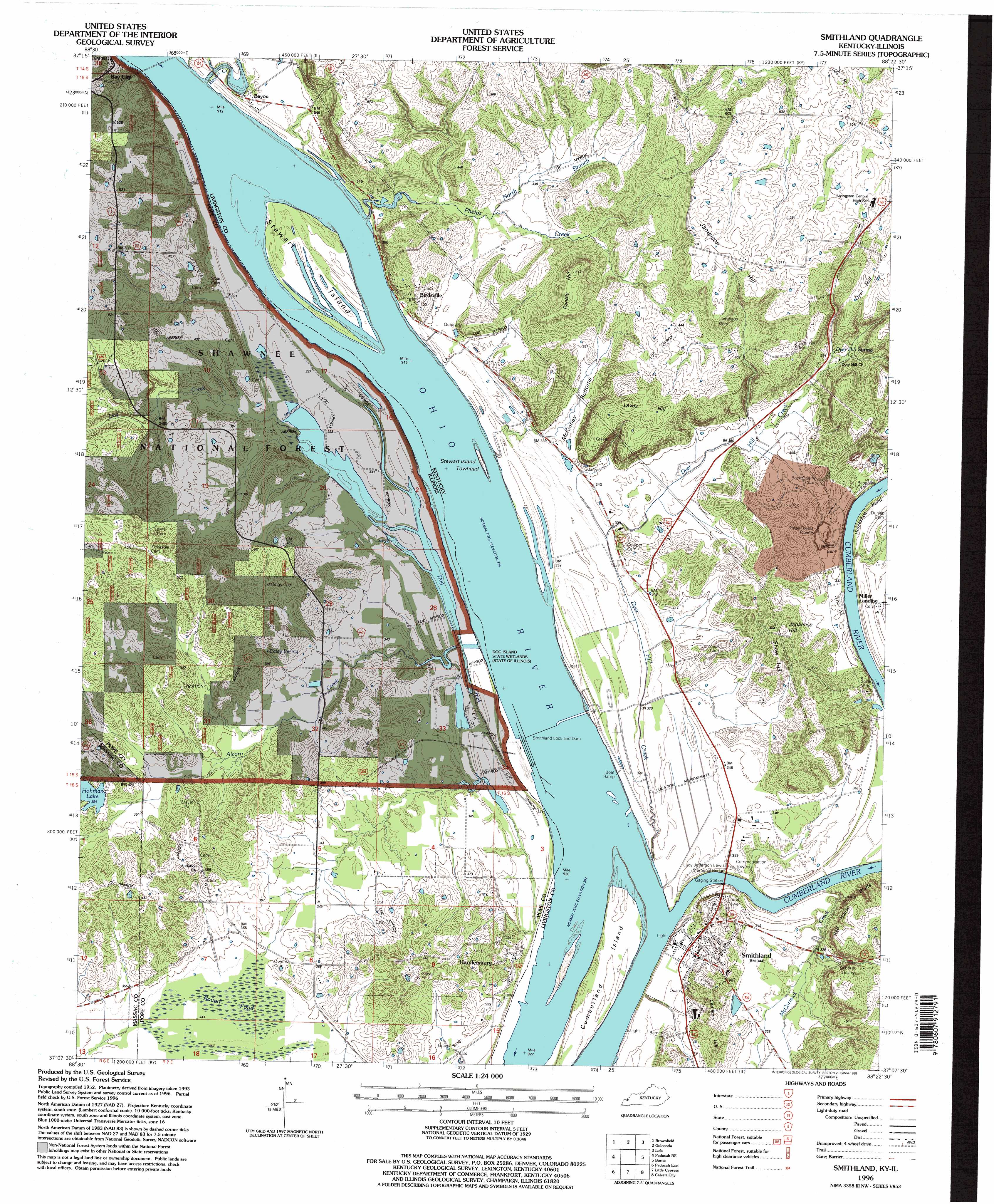
Smithland Topo Map Kentucky
To zoom in, hover over the map of Smithland
USGS Topo Quad 37088b4 - 1:24,000 scale
| Topo Map Name: | Smithland |
| USGS Topo Quad ID: | 37088b4 |
| Print Size: | ca. 21 1/4" wide x 27" high |
| Southeast Coordinates: | 37.125° N latitude / 88.375° W longitude |
| Map Center Coordinates: | 37.1875° N latitude / 88.4375° W longitude |
| U.S. States: | KY, IL |
| Filename: | o37088b4.jpg |
| Download Map JPG Image: | Smithland topo map 1:24,000 scale |
| Map Type: | Topographic |
| Topo Series: | 7.5´ |
| Map Scale: | 1:24,000 |
| Source of Map Images: | United States Geological Survey (USGS) |
| Alternate Map Versions: |
Smithland KY 1954, updated 1955 Download PDF Buy paper map Smithland KY 1967, updated 1968 Download PDF Buy paper map Smithland KY 1967, updated 1990 Download PDF Buy paper map Smithland KY 1996, updated 1998 Download PDF Buy paper map Smithland KY 2011 Download PDF Buy paper map Smithland KY 2013 Download PDF Buy paper map Smithland KY 2016 Download PDF Buy paper map |
| FStopo: | US Forest Service topo Smithland is available: Download FStopo PDF Download FStopo TIF |
1:24,000 Topo Quads surrounding Smithland
Glendale |
Waltersburg |
Shetlerville |
Rosiclare |
Cave In Rock |
Reevesville |
Brownfield |
Golconda |
Lola |
Salem |
Metropolis |
Paducah Ne |
Smithland |
Burna |
Dycusburg |
Paducah West |
Paducah East |
Little Cypress |
Calvert City |
Grand Rivers |
Melber |
Symsonia |
Elva |
Briensburg |
Birmingham Point |
> Back to 37088a1 at 1:100,000 scale
> Back to 37088a1 at 1:250,000 scale
> Back to U.S. Topo Maps home
Smithland topo map: Gazetteer
Smithland: Bends
McKinney Bottoms elevation 105m 344′Smithland: Bridges
Lucy Jefferson Lewis Memorial Bridge elevation 92m 301′Smithland: Cliffs
Red House Bluffs elevation 149m 488′Smithland: Dams
Hohman Lake Dam elevation 119m 390′Smithland Lock and Dam elevation 99m 324′
Smithland: Islands
Cumberland Island elevation 101m 331′Dog Island elevation 92m 301′
Stewart Island elevation 100m 328′
Stewart Island Towhead elevation 99m 324′
Smithland: Mines
Dyer Hill Mine elevation 156m 511′Kalberer Quarry elevation 122m 400′
Three Rivers Quarry elevation 112m 367′
Smithland: Parks
Dog Island State Wetlands elevation 100m 328′Smithland: Populated Places
Bay City elevation 103m 337′Bayou elevation 105m 344′
Birdsville elevation 131m 429′
Hamletsburg elevation 109m 357′
Miller Landing elevation 100m 328′
Smithland elevation 106m 347′
Smithland: Reservoirs
Hohman Lake elevation 119m 390′Smithland: Springs
Caley Spring elevation 113m 370′Dyer Hill Spring elevation 122m 400′
Smithland: Streams
Alcorn Creek elevation 99m 324′Bayou Creek elevation 99m 324′
Cumberland River elevation 92m 301′
Dog Creek elevation 94m 308′
Dyer Hill Creek elevation 92m 301′
McCormick Creek elevation 92m 301′
North Branch Phelps Creek elevation 100m 328′
Phelps Creek elevation 100m 328′
Smithland: Summits
Cemetery Hill elevation 129m 423′Dyer Hill elevation 183m 600′
Jameison Hill elevation 184m 603′
Japanese Hill elevation 155m 508′
Lewis Hill elevation 176m 577′
Randle Hill elevation 180m 590′
Shaw Hill elevation 152m 498′
Smithland: Swamps
Round Pond elevation 106m 347′Smithland digital topo map on disk
Buy this Smithland topo map showing relief, roads, GPS coordinates and other geographical features, as a high-resolution digital map file on DVD: