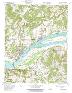
Rosiclare Topo Map Illinois
To zoom in, hover over the map of Rosiclare
USGS Topo Quad 37088d3 - 1:24,000 scale
| Topo Map Name: | Rosiclare |
| USGS Topo Quad ID: | 37088d3 |
| Print Size: | ca. 21 1/4" wide x 27" high |
| Southeast Coordinates: | 37.375° N latitude / 88.25° W longitude |
| Map Center Coordinates: | 37.4375° N latitude / 88.3125° W longitude |
| U.S. States: | IL, KY |
| Filename: | o37088d3.jpg |
| Download Map JPG Image: | Rosiclare topo map 1:24,000 scale |
| Map Type: | Topographic |
| Topo Series: | 7.5´ |
| Map Scale: | 1:24,000 |
| Source of Map Images: | United States Geological Survey (USGS) |
| Alternate Map Versions: |
Rosiclare IL 1954, updated 1955 Download PDF Buy paper map Rosiclare IL 1959, updated 1960 Download PDF Buy paper map Rosiclare IL 1959, updated 1975 Download PDF Buy paper map Rosiclare IL 1996, updated 1998 Download PDF Buy paper map Rosiclare IL 1996, updated 1999 Download PDF Buy paper map Rosiclare IL 2011 Download PDF Buy paper map Rosiclare IL 2015 Download PDF Buy paper map |
| FStopo: | US Forest Service topo Rosiclare is available: Download FStopo PDF Download FStopo TIF |
1:24,000 Topo Quads surrounding Rosiclare
> Back to 37088a1 at 1:100,000 scale
> Back to 37088a1 at 1:250,000 scale
> Back to U.S. Topo Maps home
Rosiclare topo map: Gazetteer
Rosiclare: Bridges
Milford Bridge elevation 100m 328′Rosiclare: Cliffs
Watson Bluff elevation 149m 488′Rosiclare: Dams
Whoopie Cat Dam elevation 123m 403′Rosiclare: Islands
Hurricane Island elevation 103m 337′Rosiclare: Lakes
Barnett Lake elevation 98m 321′Bennett Lake elevation 104m 341′
Lake Tacumseh elevation 123m 403′
Mud Lake elevation 101m 331′
Rosiclare: Mines
Alcoa Mine elevation 108m 354′Argo Shaft Alcoa Mine elevation 123m 403′
Austin Mine elevation 155m 508′
Buzzards Roost Shaft Alcoa Mine elevation 134m 439′
Daisy Mine elevation 127m 416′
Dimmick Mine elevation 124m 406′
Dubois Mine elevation 133m 436′
Ellis Mine elevation 109m 357′
Fairview Shaft Blue Diggings Mine elevation 122m 400′
Good Hope Mine elevation 121m 396′
Hillside Mine elevation 130m 426′
Indiana Mines elevation 133m 436′
K and R Mine elevation 151m 495′
Last Chance Shaft Blue Diggings Mine elevation 136m 446′
Martin Mine elevation 134m 439′
New Ghelia Shaft Rosiclare Mine elevation 119m 390′
Number 1 Shaft Eureka Mine elevation 127m 416′
Number 6 Shaft Eureka Mine elevation 142m 465′
Ozark Mahoning Mine elevation 115m 377′
Preen Mine elevation 132m 433′
Recovery Shaft Rosiclare Mine elevation 109m 357′
Rosiclare Mine elevation 119m 390′
Rosiclare Mine elevation 125m 410′
South Boundary Shaft Rosiclare Mine elevation 109m 357′
Stewart Shaft elevation 121m 396′
Rosiclare: Populated Places
Carrsville elevation 113m 370′Elizabethtown elevation 111m 364′
Fairview elevation 118m 387′
Mineral City (historical) elevation 104m 341′
Rosiclare elevation 108m 354′
Rosiclare: Reservoirs
Whoopie Cat Lake elevation 123m 403′Whoople Cat Lake elevation 116m 380′
Rosiclare: Streams
Barnett Branch elevation 99m 324′Big Creek elevation 100m 328′
Buck Creek elevation 99m 324′
Deer Creek elevation 99m 324′
Dry Fork elevation 101m 331′
Franklin Branch elevation 99m 324′
Goose Creek elevation 105m 344′
Hogthief Creek elevation 105m 344′
Hosick Creek elevation 99m 324′
Hurricane Creek elevation 99m 324′
Peters Creek elevation 99m 324′
Susan Creek elevation 101m 331′
Thompson Creek elevation 101m 331′
Thrilkeld Branch elevation 100m 328′
Rosiclare: Summits
Keeling Hill elevation 200m 656′Lavender Hill elevation 140m 459′
Rosiclare: Valleys
Holbrook Hollow elevation 117m 383′Rosiclare digital topo map on disk
Buy this Rosiclare topo map showing relief, roads, GPS coordinates and other geographical features, as a high-resolution digital map file on DVD:


