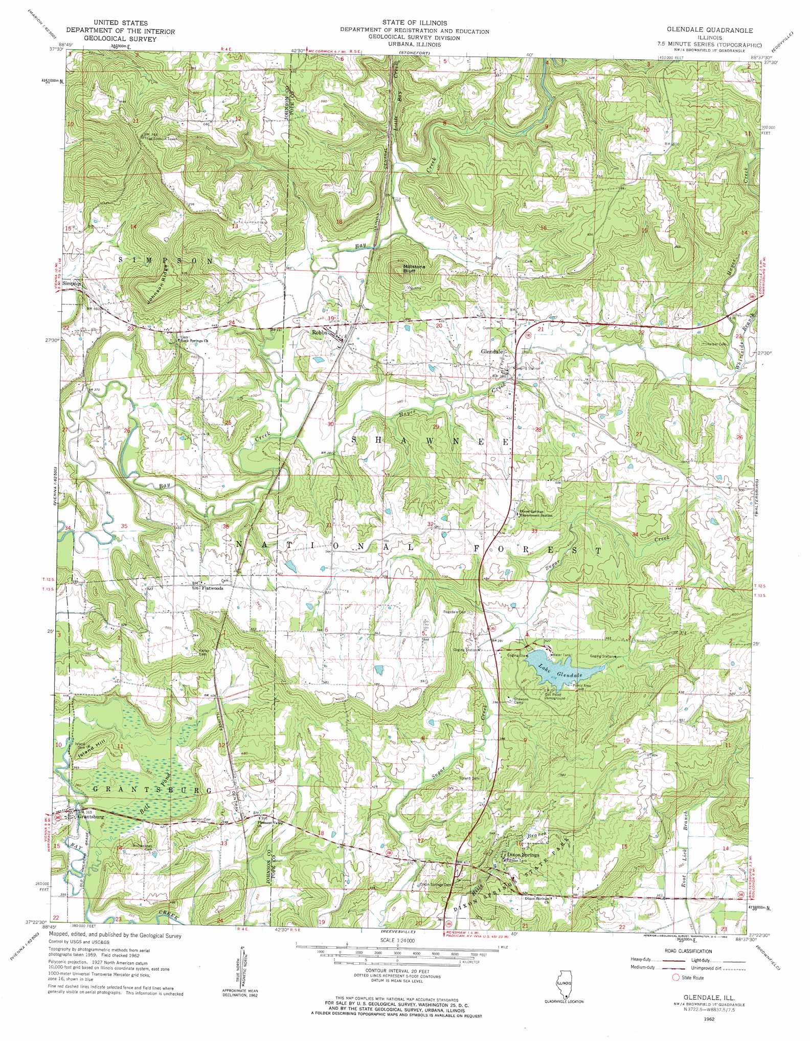
Glendale Topo Map Illinois
To zoom in, hover over the map of Glendale
USGS Topo Quad 37088d6 - 1:24,000 scale
| Topo Map Name: | Glendale |
| USGS Topo Quad ID: | 37088d6 |
| Print Size: | ca. 21 1/4" wide x 27" high |
| Southeast Coordinates: | 37.375° N latitude / 88.625° W longitude |
| Map Center Coordinates: | 37.4375° N latitude / 88.6875° W longitude |
| U.S. State: | IL |
| Filename: | o37088d6.jpg |
| Download Map JPG Image: | Glendale topo map 1:24,000 scale |
| Map Type: | Topographic |
| Topo Series: | 7.5´ |
| Map Scale: | 1:24,000 |
| Source of Map Images: | United States Geological Survey (USGS) |
| Alternate Map Versions: |
Glendale IL 1962, updated 1963 Download PDF Buy paper map Glendale IL 1996, updated 1998 Download PDF Buy paper map Glendale IL 2012 Download PDF Buy paper map Glendale IL 2015 Download PDF Buy paper map |
| FStopo: | US Forest Service topo Glendale is available: Download FStopo PDF Download FStopo TIF |
1:24,000 Topo Quads surrounding Glendale
Marion |
Crab Orchard |
Carrier Mills |
Harrisburg |
Rudement |
Goreville |
Creal Springs |
Stonefort |
Eddyville |
Herod |
Vienna |
Bloomfield |
Glendale |
Waltersburg |
Shetlerville |
Karnak |
Mermet |
Reevesville |
Brownfield |
Golconda |
Bandana |
Joppa |
Metropolis |
Paducah Ne |
Smithland |
> Back to 37088a1 at 1:100,000 scale
> Back to 37088a1 at 1:250,000 scale
> Back to U.S. Topo Maps home
Glendale topo map: Gazetteer
Glendale: Airports
Dixon Springs RLA Airport elevation 166m 544′Glendale: Crossings
Carvel Ford elevation 122m 400′Glendale: Dams
Bay Creek Structure Number 5 Dam elevation 123m 403′Bay Creek Structure Number 8 Dam elevation 111m 364′
Lake Glendale Dam elevation 127m 416′
Simpson Lake Dam elevation 119m 390′
Glendale: Parks
Dixon Springs State Park elevation 155m 508′Millstone Bluff National Register Site elevation 206m 675′
Glendale: Populated Places
Dixon Springs elevation 146m 479′Flatwoods elevation 161m 528′
Glendale elevation 126m 413′
Grantsburg elevation 115m 377′
Robbs elevation 138m 452′
Glendale: Post Offices
Glendale Post Office (historical) elevation 118m 387′Grantsburg Post Office elevation 113m 370′
Robbs Post Office elevation 137m 449′
Glendale: Reservoirs
Lake Glendale elevation 127m 416′Simpson Lake elevation 119m 390′
Sugar Creek Lake elevation 110m 360′
Glendale: Ridges
Johnson Ridge elevation 219m 718′Glendale: Springs
Dixon Springs elevation 134m 439′Glendale: Streams
Hayes Creek elevation 116m 380′Johnson Creek elevation 107m 351′
Little Bay Creek elevation 117m 383′
Whiteside Branch elevation 122m 400′
Glendale: Summits
Island Hill elevation 139m 456′Millstone Bluff elevation 221m 725′
Glendale: Swamps
Bell Pond elevation 107m 351′Glendale: Trails
River to River Trail elevation 174m 570′Glendale: Valleys
Pine Hollow elevation 109m 357′Glendale digital topo map on disk
Buy this Glendale topo map showing relief, roads, GPS coordinates and other geographical features, as a high-resolution digital map file on DVD: