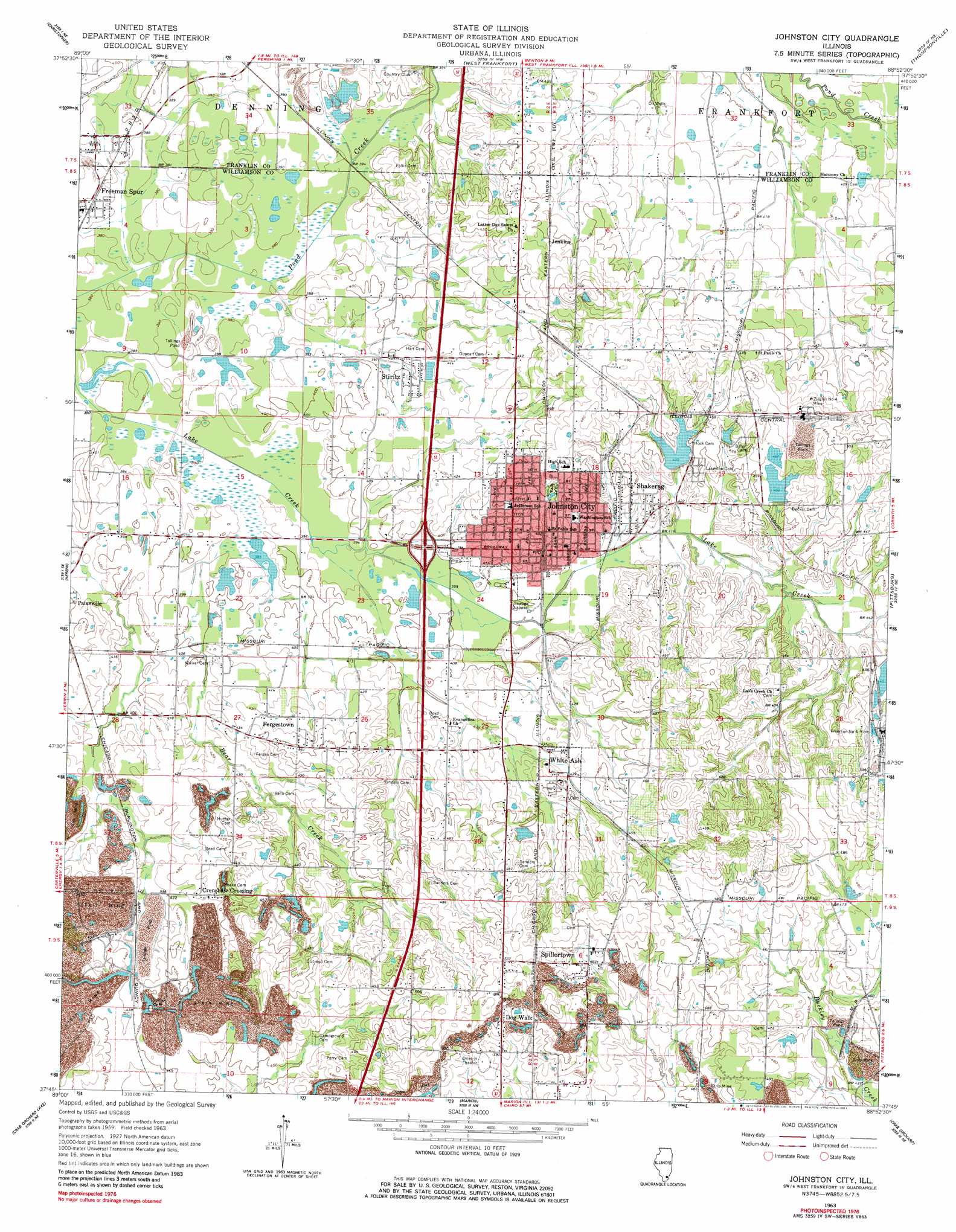
Johnston City Topo Map Illinois
To zoom in, hover over the map of Johnston City
USGS Topo Quad 37088g8 - 1:24,000 scale
| Topo Map Name: | Johnston City |
| USGS Topo Quad ID: | 37088g8 |
| Print Size: | ca. 21 1/4" wide x 27" high |
| Southeast Coordinates: | 37.75° N latitude / 88.875° W longitude |
| Map Center Coordinates: | 37.8125° N latitude / 88.9375° W longitude |
| U.S. State: | IL |
| Filename: | o37088g8.jpg |
| Download Map JPG Image: | Johnston City topo map 1:24,000 scale |
| Map Type: | Topographic |
| Topo Series: | 7.5´ |
| Map Scale: | 1:24,000 |
| Source of Map Images: | United States Geological Survey (USGS) |
| Alternate Map Versions: |
Johnston City IL 1963, updated 1964 Download PDF Buy paper map Johnston City IL 1963, updated 1981 Download PDF Buy paper map Johnston City IL 2012 Download PDF Buy paper map Johnston City IL 2015 Download PDF Buy paper map |
1:24,000 Topo Quads surrounding Johnston City
Du Quoin |
Sesser |
Rend Lake Dam |
Ewing |
Macedonia |
Elkville |
Christopher |
West Frankfort |
Thompsonville |
Akin |
Desoto |
Herrin |
Johnston City |
Pittsburg |
Harco |
Carbondale |
Crab Orchard Lake |
Marion |
Crab Orchard |
Carrier Mills |
Makanda |
Lick Creek |
Goreville |
Creal Springs |
Stonefort |
> Back to 37088e1 at 1:100,000 scale
> Back to 37088a1 at 1:250,000 scale
> Back to U.S. Topo Maps home
Johnston City topo map: Gazetteer
Johnston City: Crossings
Interchange 59 elevation 125m 410′Johnston City: Dams
Illinois No Name Number 2010 Dam elevation 129m 423′Johnston City Sewage Lagoon Dam elevation 123m 403′
Lake Number 5 Dam elevation 138m 452′
Sweet Lake Dam elevation 130m 426′
Johnston City: Mines
Freeman Number 4 Mine elevation 148m 485′Ziegler Number 4 Mine elevation 147m 482′
Johnston City: Populated Places
Crenshaw Crossing elevation 134m 439′Dog Walk elevation 151m 495′
Fergestown elevation 137m 449′
Freeman Spur elevation 120m 393′
Jenkins elevation 139m 456′
Johnston City elevation 130m 426′
Shakerag elevation 134m 439′
Spillertown elevation 147m 482′
Stiritz elevation 123m 403′
White Ash elevation 134m 439′
Johnston City: Post Offices
Johnston City Post Office elevation 128m 419′Johnston City: Reservoirs
Johnston City Sewage Lagoon elevation 123m 403′Lake Number 5 elevation 138m 452′
Sweet Lake elevation 130m 426′
Johnston City: Streams
Bear Creek elevation 119m 390′Johnston City digital topo map on disk
Buy this Johnston City topo map showing relief, roads, GPS coordinates and other geographical features, as a high-resolution digital map file on DVD: