Tamms Topo Map Illinois
To zoom in, hover over the map of Tamms
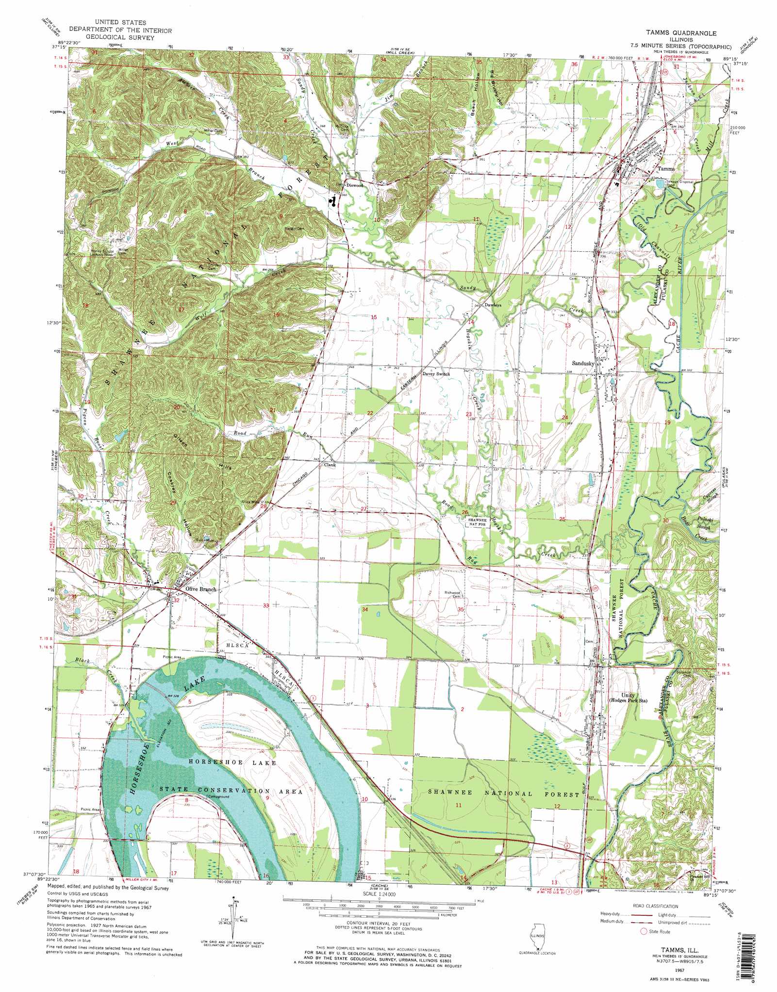
USGS Topo Quad 37089b3 - 1:24,000 scale
| Topo Map Name: | Tamms |
| USGS Topo Quad ID: | 37089b3 |
| Print Size: | ca. 21 1/4" wide x 27" high |
| Southeast Coordinates: | 37.125° N latitude / 89.25° W longitude |
| Map Center Coordinates: | 37.1875° N latitude / 89.3125° W longitude |
| U.S. State: | IL |
| Filename: | o37089b3.jpg |
| Download Map JPG Image: | Tamms topo map 1:24,000 scale |
| Map Type: | Topographic |
| Topo Series: | 7.5´ |
| Map Scale: | 1:24,000 |
| Source of Map Images: | United States Geological Survey (USGS) |
| Alternate Map Versions: |
Tamms IL 1967, updated 1968 Download PDF Buy paper map Tamms IL 1967, updated 1968 Download PDF Buy paper map Tamms IL 1996, updated 1998 Download PDF Buy paper map Tamms IL 1996, updated 1998 Download PDF Buy paper map Tamms IL 2012 Download PDF Buy paper map Tamms IL 2015 Download PDF Buy paper map |
| FStopo: | US Forest Service topo Tamms is available: Download FStopo PDF Download FStopo TIF |
1:24,000 Topo Quads surrounding Tamms
Cape Girardeau Ne |
Ware |
Jonesboro |
Anna |
Mount Pleasant |
Cape Girardeau |
Mcclure |
Mill Creek |
Dongola |
Cypress |
Scott City |
Thebes |
Tamms |
Pulaski |
Olmsted |
Morley |
Thebes Sw |
Cache |
Cairo |
Barlow |
Sikeston North |
Bertrand |
Charleston |
Wyatt |
Wickliffe |
> Back to 37089a1 at 1:100,000 scale
> Back to 37088a1 at 1:250,000 scale
> Back to U.S. Topo Maps home
Tamms topo map: Gazetteer
Tamms: Lakes
Horseshoe Lake elevation 98m 321′Tamms: Mines
Silica Mine elevation 104m 341′Tamms: Parks
Horseshoe Lake Nature Preserve elevation 99m 324′Horseshoe Lake State Conservation Area elevation 98m 321′
Tamms: Populated Places
Clank elevation 104m 341′Dawleys elevation 104m 341′
Diswood elevation 110m 360′
Hodges Park elevation 101m 331′
Olive Branch elevation 103m 337′
Sandusky elevation 104m 341′
Tamms elevation 104m 341′
Unity elevation 102m 334′
Tamms: Post Offices
Olive Branch Post Office elevation 104m 341′Tamms: Streams
Ambeer Creek elevation 116m 380′Black Creek elevation 98m 321′
Boar Creek elevation 97m 318′
Cypress Slough elevation 98m 321′
Hogskin Creek elevation 98m 321′
Jackson Creek elevation 98m 321′
Jim Branch elevation 106m 347′
Mill Creek elevation 98m 321′
Old Channel elevation 97m 318′
Pigeon Roost Creek elevation 98m 321′
Pulaski Slough elevation 98m 321′
Road Run elevation 98m 321′
Sandy Creek elevation 97m 318′
West Branch Sandy Creek elevation 106m 347′
Wolf Creek elevation 104m 341′
Tamms: Summits
Gilson Hills elevation 143m 469′Tamms: Swamps
Hogskin Bottoms elevation 104m 341′Tamms: Valleys
Beech Hollow elevation 110m 360′Big Brushy Hollow elevation 114m 374′
Coakley Hollow elevation 107m 351′
Tamms digital topo map on disk
Buy this Tamms topo map showing relief, roads, GPS coordinates and other geographical features, as a high-resolution digital map file on DVD: