Marble Hill Topo Map Missouri
To zoom in, hover over the map of Marble Hill
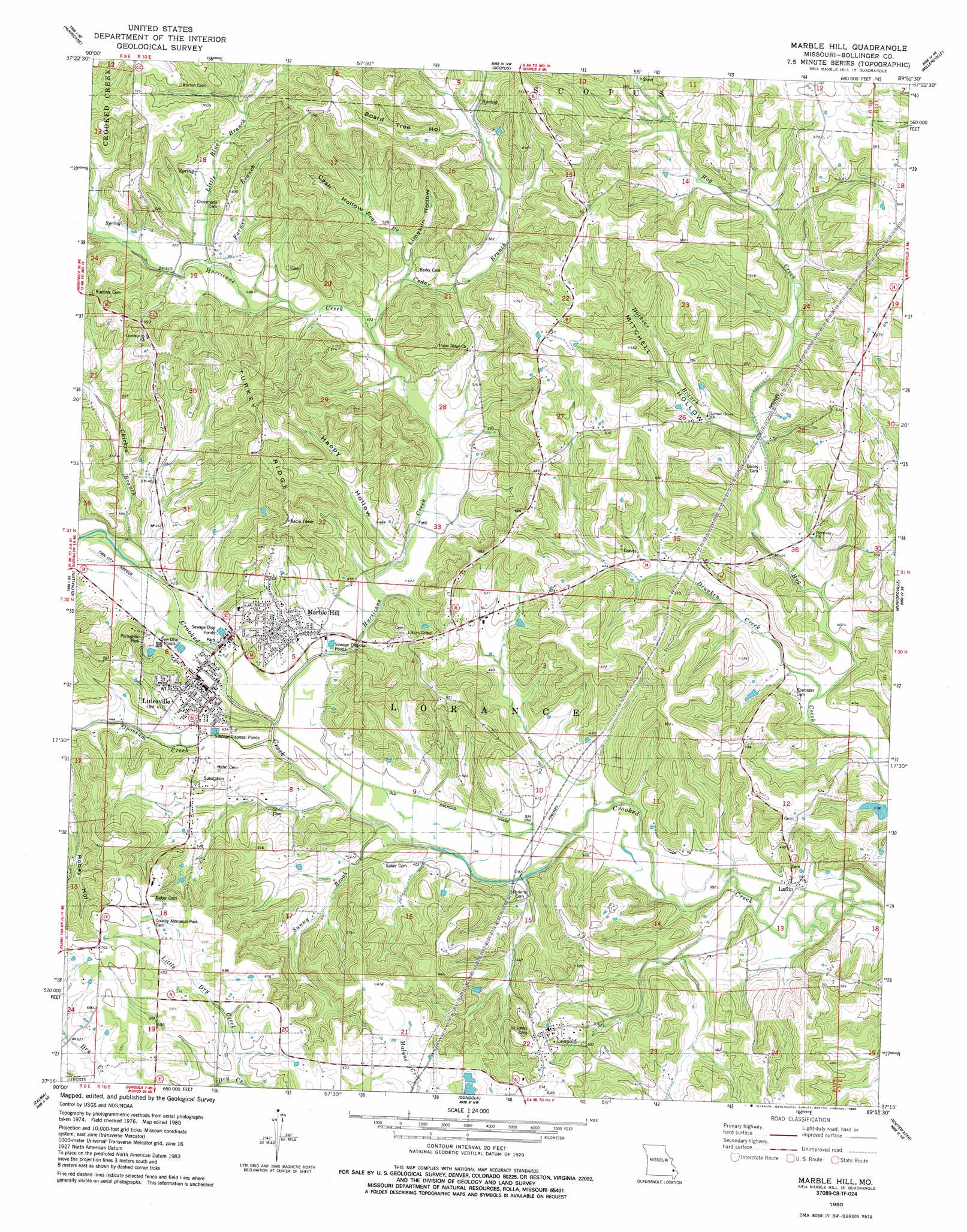
USGS Topo Quad 37089c8 - 1:24,000 scale
| Topo Map Name: | Marble Hill |
| USGS Topo Quad ID: | 37089c8 |
| Print Size: | ca. 21 1/4" wide x 27" high |
| Southeast Coordinates: | 37.25° N latitude / 89.875° W longitude |
| Map Center Coordinates: | 37.3125° N latitude / 89.9375° W longitude |
| U.S. State: | MO |
| Filename: | o37089c8.jpg |
| Download Map JPG Image: | Marble Hill topo map 1:24,000 scale |
| Map Type: | Topographic |
| Topo Series: | 7.5´ |
| Map Scale: | 1:24,000 |
| Source of Map Images: | United States Geological Survey (USGS) |
| Alternate Map Versions: |
Marble Hill MO 1980, updated 1980 Download PDF Buy paper map Marble Hill MO 1980, updated 1986 Download PDF Buy paper map Marble Hill MO 2012 Download PDF Buy paper map Marble Hill MO 2015 Download PDF Buy paper map |
1:24,000 Topo Quads surrounding Marble Hill
Higdon |
Patton |
Sedgewickville |
Friedheim |
Oak Ridge |
Marquand |
Hurricane |
Scopus |
Millersville |
Jackson |
Allbright |
Glenallen |
Marble Hill |
Bufordville |
Gordonville |
Gipsy |
Zalma |
Dongola |
Whitewater |
Chaffee |
Mcgee |
Sturdivant |
Advance |
Bell City |
Oran |
> Back to 37089a1 at 1:100,000 scale
> Back to 37088a1 at 1:250,000 scale
> Back to U.S. Topo Maps home
Marble Hill topo map: Gazetteer
Marble Hill: Airports
Twin City Airpark elevation 128m 419′Marble Hill: Dams
Bollinger Lake Dam elevation 135m 442′Lukefahr Lake Dam elevation 122m 400′
Shrum Lake Dam elevation 151m 495′
Marble Hill: Parks
Pellegrino Park elevation 146m 479′Marble Hill: Populated Places
Huskey elevation 132m 433′Laflin elevation 121m 396′
Leopold elevation 192m 629′
Lutesville elevation 128m 419′
Marble Hill elevation 149m 488′
Marble Hill: Reservoirs
Bollinger Lake elevation 135m 442′Lukefahr Lake elevation 122m 400′
Marble Hill: Ridges
Turkey Ridge elevation 209m 685′Marble Hill: Streams
Bear Branch elevation 146m 479′Cedar Branch elevation 140m 459′
Chicken Branch elevation 128m 419′
Dockins Branch elevation 128m 419′
Drunken Creek elevation 117m 383′
Farmer Branch elevation 148m 485′
Hurricane Creek elevation 123m 403′
Little Blue Branch elevation 148m 485′
Little Dry Creek elevation 165m 541′
Opossum Creek elevation 116m 380′
Sunny Brook elevation 116m 380′
Marble Hill: Summits
Turkey Hill elevation 226m 741′Marble Hill: Valleys
Board Tree Hollow elevation 174m 570′Cash Hollow elevation 162m 531′
Happy Hollow elevation 127m 416′
Limekiln Hollow elevation 150m 492′
Mitchell Hollow elevation 128m 419′
Marble Hill digital topo map on disk
Buy this Marble Hill topo map showing relief, roads, GPS coordinates and other geographical features, as a high-resolution digital map file on DVD: