Cape Girardeau Ne Topo Map Missouri
To zoom in, hover over the map of Cape Girardeau Ne
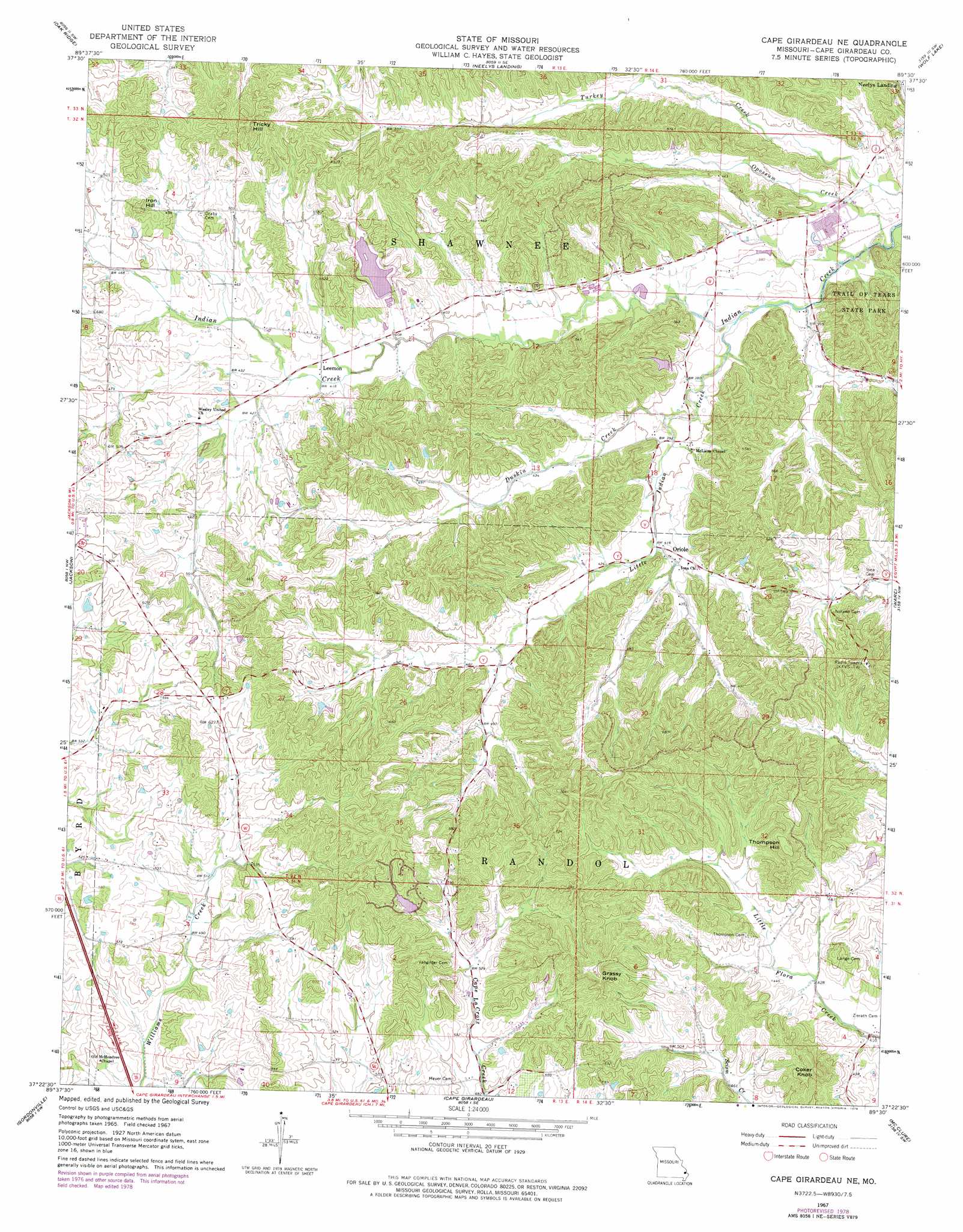
USGS Topo Quad 37089d5 - 1:24,000 scale
| Topo Map Name: | Cape Girardeau Ne |
| USGS Topo Quad ID: | 37089d5 |
| Print Size: | ca. 21 1/4" wide x 27" high |
| Southeast Coordinates: | 37.375° N latitude / 89.5° W longitude |
| Map Center Coordinates: | 37.4375° N latitude / 89.5625° W longitude |
| U.S. State: | MO |
| Filename: | o37089d5.jpg |
| Download Map JPG Image: | Cape Girardeau Ne topo map 1:24,000 scale |
| Map Type: | Topographic |
| Topo Series: | 7.5´ |
| Map Scale: | 1:24,000 |
| Source of Map Images: | United States Geological Survey (USGS) |
| Alternate Map Versions: |
Cape Girardeau NE MO 1967, updated 1968 Download PDF Buy paper map Cape Girardeau NE MO 1967, updated 1978 Download PDF Buy paper map Cape Girardeau NE MO 1993, updated 1996 Download PDF Buy paper map Cape Girardeau NE MO 2012 Download PDF Buy paper map Cape Girardeau NE MO 2015 Download PDF Buy paper map |
1:24,000 Topo Quads surrounding Cape Girardeau Ne
Perryville East |
Crosstown |
Altenburg |
Gorham |
Pomona |
Friedheim |
Oak Ridge |
Neelys Landing |
Wolf Lake |
Cobden |
Millersville |
Jackson |
Cape Girardeau Ne |
Ware |
Jonesboro |
Bufordville |
Gordonville |
Cape Girardeau |
Mcclure |
Mill Creek |
Whitewater |
Chaffee |
Scott City |
Thebes |
Tamms |
> Back to 37089a1 at 1:100,000 scale
> Back to 37088a1 at 1:250,000 scale
> Back to U.S. Topo Maps home
Cape Girardeau Ne topo map: Gazetteer
Cape Girardeau Ne: Dams
Lipps Dam elevation 134m 439′North Hills Estate Subdivision Lake Dam elevation 179m 587′
Number 819 Dam elevation 143m 469′
Cape Girardeau Ne: Populated Places
Leemon elevation 128m 419′Oriole elevation 126m 413′
Cape Girardeau Ne: Reservoirs
Bella Vista Lake elevation 143m 469′Lipps Lake elevation 134m 439′
North Hills Estate Subdivision Lake elevation 179m 587′
Cape Girardeau Ne: Streams
Duskin Creek elevation 114m 374′Little Indian Creek elevation 107m 351′
Opossum Creek elevation 105m 344′
Cape Girardeau Ne: Summits
Coker Knob elevation 227m 744′Grassy Knob elevation 244m 800′
Iron Hill elevation 190m 623′
Thompson Hill elevation 220m 721′
Tricky Hill elevation 220m 721′
Cape Girardeau Ne digital topo map on disk
Buy this Cape Girardeau Ne topo map showing relief, roads, GPS coordinates and other geographical features, as a high-resolution digital map file on DVD: