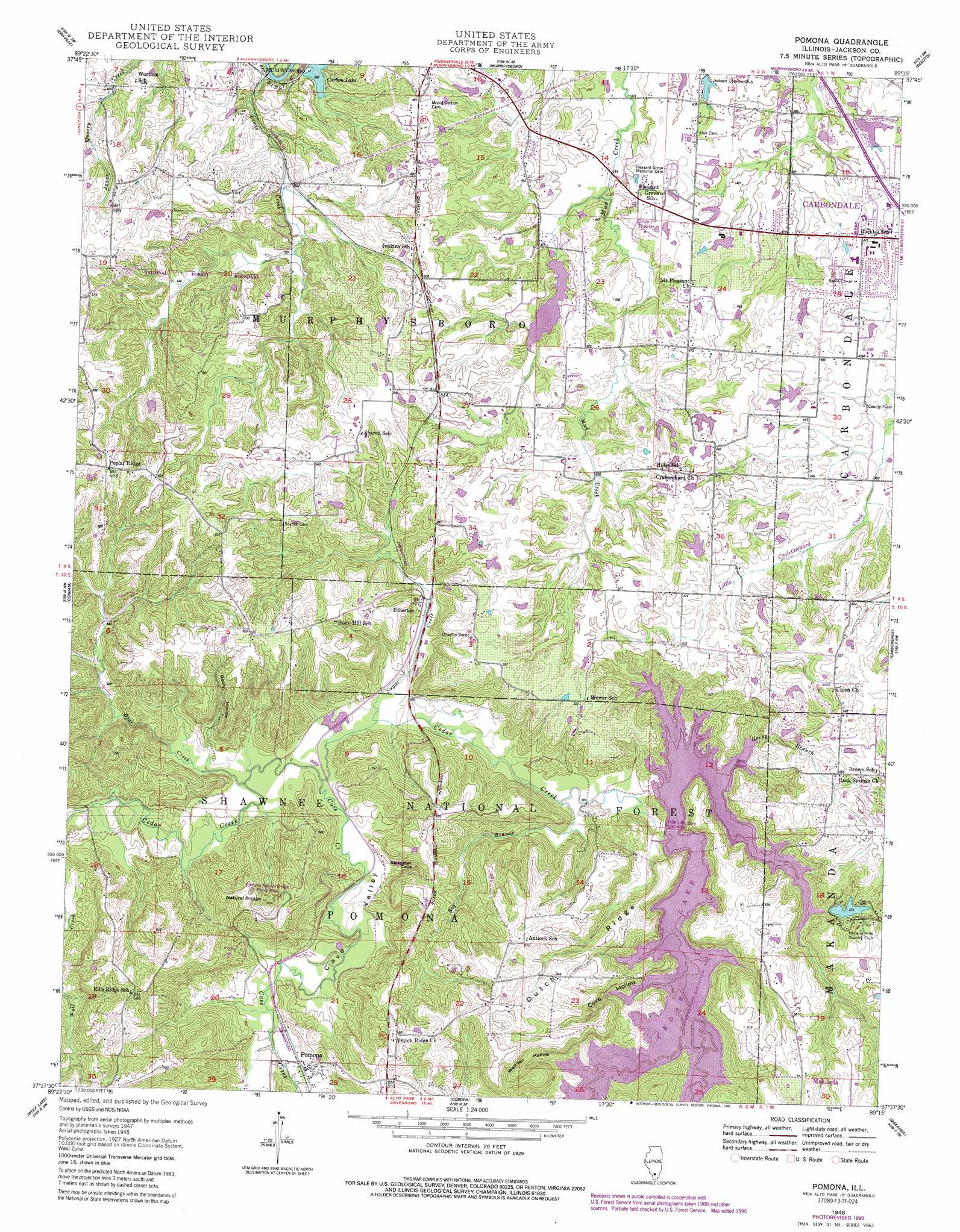
Pomona Topo Map Illinois
To zoom in, hover over the map of Pomona
USGS Topo Quad 37089f3 - 1:24,000 scale
| Topo Map Name: | Pomona |
| USGS Topo Quad ID: | 37089f3 |
| Print Size: | ca. 21 1/4" wide x 27" high |
| Southeast Coordinates: | 37.625° N latitude / 89.25° W longitude |
| Map Center Coordinates: | 37.6875° N latitude / 89.3125° W longitude |
| U.S. State: | IL |
| Filename: | o37089f3.jpg |
| Download Map JPG Image: | Pomona topo map 1:24,000 scale |
| Map Type: | Topographic |
| Topo Series: | 7.5´ |
| Map Scale: | 1:24,000 |
| Source of Map Images: | United States Geological Survey (USGS) |
| Alternate Map Versions: |
Pomona IL 1948 Download PDF Buy paper map Pomona IL 1948 Download PDF Buy paper map Pomona IL 1948, updated 1978 Download PDF Buy paper map Pomona IL 1948, updated 1990 Download PDF Buy paper map Pomona IL 1996, updated 1998 Download PDF Buy paper map Pomona IL 2012 Download PDF Buy paper map Pomona IL 2015 Download PDF Buy paper map |
| FStopo: | US Forest Service topo Pomona is available: Download FStopo PDF Download FStopo TIF |
1:24,000 Topo Quads surrounding Pomona
Willisville |
Ava |
Vergennes |
Elkville |
Christopher |
Raddle |
Oraville |
Murphysboro |
Desoto |
Herrin |
Altenburg |
Gorham |
Pomona |
Carbondale |
Crab Orchard Lake |
Neelys Landing |
Wolf Lake |
Cobden |
Makanda |
Lick Creek |
Cape Girardeau Ne |
Ware |
Jonesboro |
Anna |
Mount Pleasant |
> Back to 37089e1 at 1:100,000 scale
> Back to 37088a1 at 1:250,000 scale
> Back to U.S. Topo Maps home
Pomona topo map: Gazetteer
Pomona: Arches
Pomona Natural Bridge elevation 162m 531′Pomona: Dams
Borgsmiller Lake Dam elevation 147m 482′Cedar Lake Dam elevation 132m 433′
Chautauqua Lake Dam elevation 125m 410′
New Thompson Lake Dam elevation 123m 403′
Pomona: Lakes
Carbon Lake elevation 111m 364′Pomona: Populated Places
Eltham (historical) elevation 116m 380′Etherton elevation 119m 390′
Pomona elevation 124m 406′
Poplar Ridge elevation 192m 629′
Pomona: Reservoirs
Borgsmiller Lake elevation 147m 482′Cedar Lake elevation 132m 433′
Chautauqua Lake elevation 125m 410′
Deer Lake elevation 130m 426′
New Thompson Lake elevation 123m 403′
Thompson Lake elevation 123m 403′
Pomona: Ridges
Dutch Ridge elevation 180m 590′Pomona: Streams
Bear Creek elevation 110m 360′Big Branch elevation 119m 390′
Cave Creek elevation 110m 360′
Lewis Creek elevation 102m 334′
Poplar Camp Creek elevation 132m 433′
Rocky Branch elevation 136m 446′
Sugar Creek elevation 113m 370′
Pomona: Summits
Mount Carbon elevation 146m 479′Pomona: Valleys
Cave Valley elevation 112m 367′Cove Hollow elevation 132m 433′
Rocky Hollow elevation 116m 380′
Wolfden Hollow elevation 132m 433′
Pomona digital topo map on disk
Buy this Pomona topo map showing relief, roads, GPS coordinates and other geographical features, as a high-resolution digital map file on DVD: