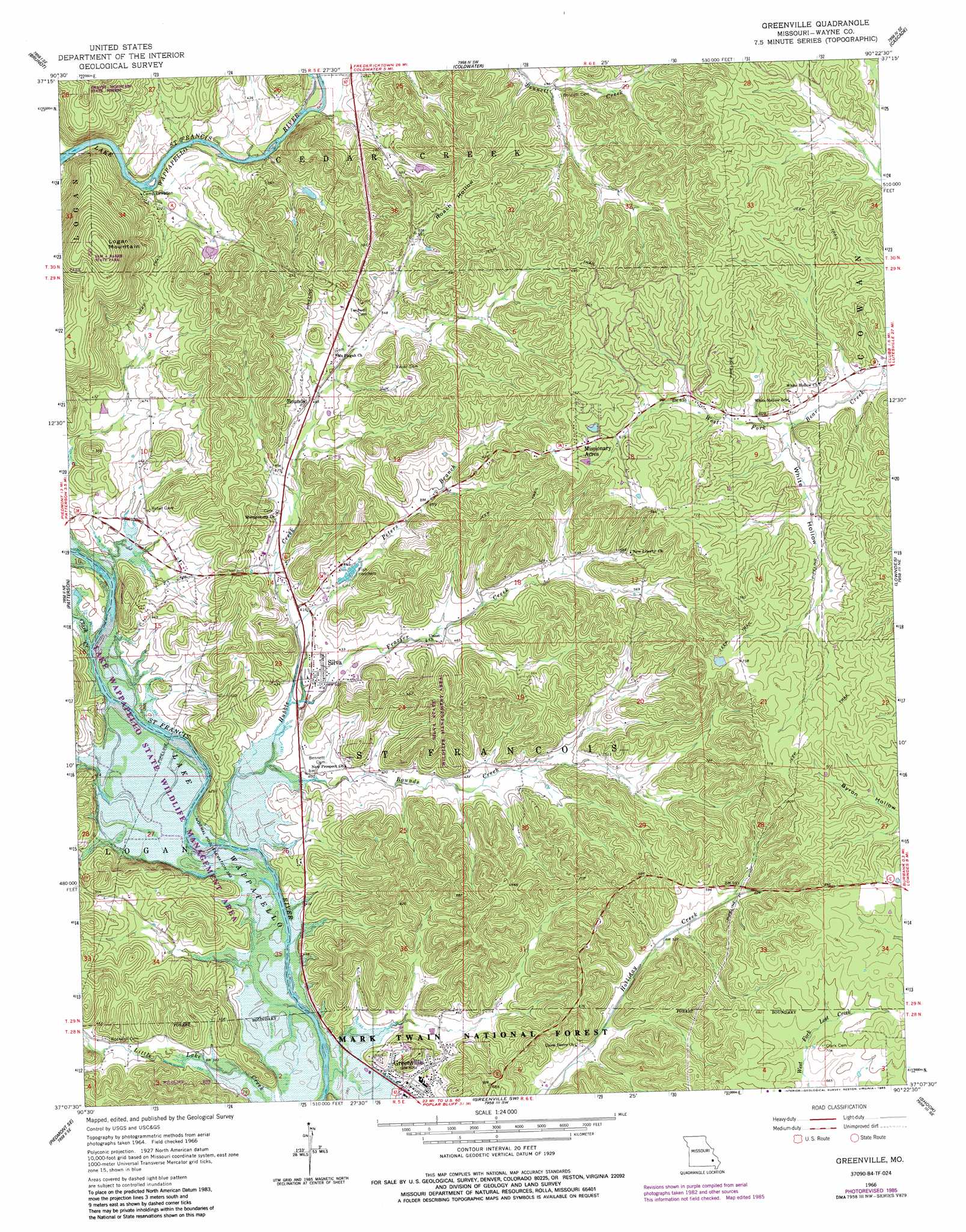
Greenville Topo Map Missouri
To zoom in, hover over the map of Greenville
USGS Topo Quad 37090b4 - 1:24,000 scale
| Topo Map Name: | Greenville |
| USGS Topo Quad ID: | 37090b4 |
| Print Size: | ca. 21 1/4" wide x 27" high |
| Southeast Coordinates: | 37.125° N latitude / 90.375° W longitude |
| Map Center Coordinates: | 37.1875° N latitude / 90.4375° W longitude |
| U.S. State: | MO |
| Filename: | o37090b4.jpg |
| Download Map JPG Image: | Greenville topo map 1:24,000 scale |
| Map Type: | Topographic |
| Topo Series: | 7.5´ |
| Map Scale: | 1:24,000 |
| Source of Map Images: | United States Geological Survey (USGS) |
| Alternate Map Versions: |
Greenville MO 1966, updated 1967 Download PDF Buy paper map Greenville MO 1966, updated 1985 Download PDF Buy paper map Greenville MO 2011 Download PDF Buy paper map Greenville MO 2015 Download PDF Buy paper map |
| FStopo: | US Forest Service topo Greenville is available: Download FStopo PDF Download FStopo TIF |
1:24,000 Topo Quads surrounding Greenville
Glover |
Des Arc Ne |
Rock Pile Mountain |
Cherokee Pass |
Marquand |
Des Arc |
Brunot |
Coldwater |
Cascade |
Allbright |
Piedmont |
Patterson |
Greenville |
Lowndes |
Gipsy |
Mill Spring |
Piedmont Se |
Greenville Sw |
Shook |
Mcgee |
Ellsinore |
Williamsville |
Hendrickson |
Wappapello |
Puxico |
> Back to 37090a1 at 1:100,000 scale
> Back to 37090a1 at 1:250,000 scale
> Back to U.S. Topo Maps home
Greenville topo map: Gazetteer
Greenville: Dams
Lake Potashnik Dam elevation 161m 528′Greenville: Parks
Lake Wappapella State Wildlife Management Area elevation 135m 442′Silva State Wildlife Management Area elevation 170m 557′
Greenville: Populated Places
Bounds elevation 150m 492′Greenville elevation 124m 406′
Missionary Acres elevation 225m 738′
Silva elevation 123m 403′
Greenville: Post Offices
Silva Post Office (historical) elevation 122m 400′Greenville: Reservoirs
Lake Potashnik elevation 161m 528′Greenville: Streams
Bounds Creek elevation 116m 380′Clark Creek elevation 113m 370′
Frazier Creek elevation 118m 387′
Granny Branch elevation 230m 754′
Hubble Creek elevation 113m 370′
Peters Branch elevation 122m 400′
Greenville: Summits
Kelly Hill elevation 117m 383′Logan Mountain elevation 312m 1023′
Greenville: Valleys
Roach Hollow elevation 177m 580′Wet Hollow elevation 151m 495′
White Hollow elevation 180m 590′
Greenville digital topo map on disk
Buy this Greenville topo map showing relief, roads, GPS coordinates and other geographical features, as a high-resolution digital map file on DVD: