Des Arc Topo Map Missouri
To zoom in, hover over the map of Des Arc
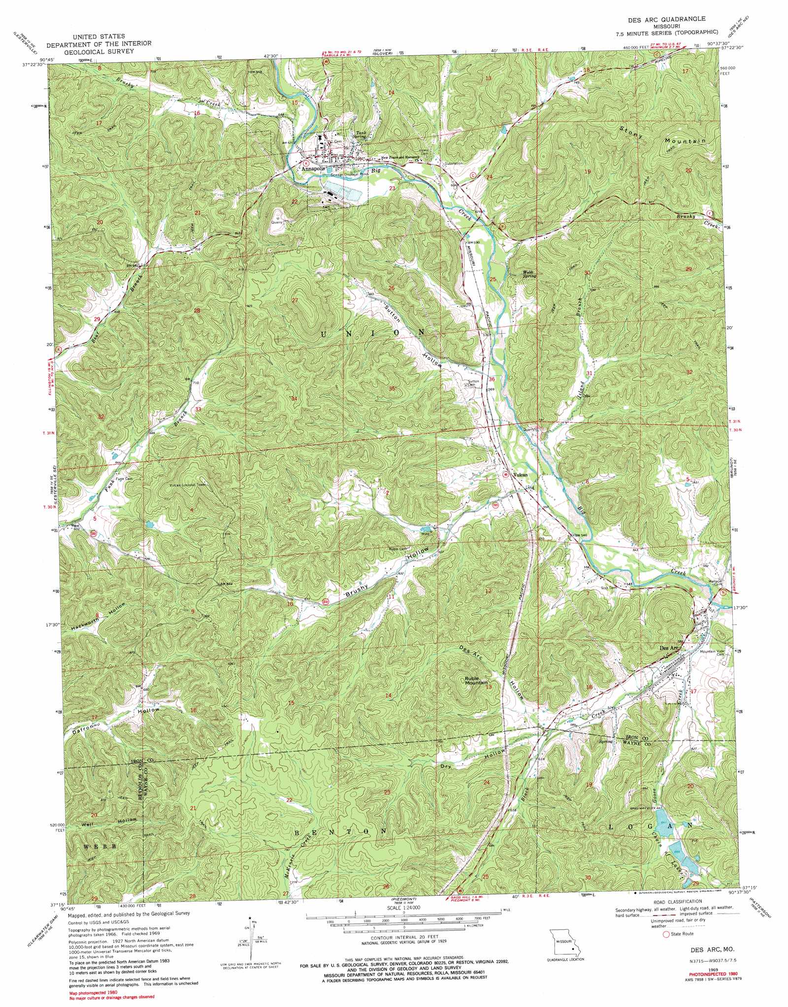
USGS Topo Quad 37090c6 - 1:24,000 scale
| Topo Map Name: | Des Arc |
| USGS Topo Quad ID: | 37090c6 |
| Print Size: | ca. 21 1/4" wide x 27" high |
| Southeast Coordinates: | 37.25° N latitude / 90.625° W longitude |
| Map Center Coordinates: | 37.3125° N latitude / 90.6875° W longitude |
| U.S. State: | MO |
| Filename: | o37090c6.jpg |
| Download Map JPG Image: | Des Arc topo map 1:24,000 scale |
| Map Type: | Topographic |
| Topo Series: | 7.5´ |
| Map Scale: | 1:24,000 |
| Source of Map Images: | United States Geological Survey (USGS) |
| Alternate Map Versions: |
Des Arc MO 1969, updated 1970 Download PDF Buy paper map Des Arc MO 1969, updated 1979 Download PDF Buy paper map Des Arc MO 1969, updated 1983 Download PDF Buy paper map Des Arc MO 2011 Download PDF Buy paper map Des Arc MO 2015 Download PDF Buy paper map |
1:24,000 Topo Quads surrounding Des Arc
Edgehill |
Johnson Shut-Ins |
Ironton |
Lake Killarney |
Rhodes Mountain |
Centerville |
Lesterville |
Glover |
Des Arc Ne |
Rock Pile Mountain |
Redford |
Lesterville Se |
Des Arc |
Brunot |
Coldwater |
Ellington |
Clearwater Dam |
Piedmont |
Patterson |
Greenville |
Garwood |
Ellington Se |
Mill Spring |
Piedmont Se |
Greenville Sw |
> Back to 37090a1 at 1:100,000 scale
> Back to 37090a1 at 1:250,000 scale
> Back to U.S. Topo Maps home
Des Arc topo map: Gazetteer
Des Arc: Dams
Chain of Lakes Dam Number 1 elevation 195m 639′Chain of Lakes Dam Number 2 elevation 203m 666′
Chain of Lakes Dam Number 3 elevation 207m 679′
Des Arc: Lakes
Slab Pond elevation 268m 879′Des Arc: Mines
Annapolis Lead Mines elevation 288m 944′Dinger Iron Bank elevation 226m 741′
Singer Iron Bank elevation 190m 623′
Des Arc: Populated Places
Annapolis elevation 199m 652′Des Arc elevation 165m 541′
Vulcan elevation 169m 554′
Des Arc: Reservoirs
Chain of Lakes elevation 195m 639′Shy Lake elevation 203m 666′
Shy Lake elevation 207m 679′
Shy Lake 2 elevation 195m 639′
Des Arc: Springs
Tank Spring elevation 202m 662′Webb Spring elevation 197m 646′
Des Arc: Streams
Black Creek elevation 159m 521′Brushy Creek elevation 189m 620′
Goose Creek elevation 157m 515′
Island Branch elevation 165m 541′
Kinney Branch elevation 178m 583′
Des Arc: Summits
Lewis Mountain elevation 268m 879′Ruble Mountain elevation 306m 1003′
Stony Mountain elevation 360m 1181′
Des Arc: Valleys
Brushy Hollow elevation 172m 564′Cedar Spring Hollow elevation 160m 524′
Des Acre Hollow elevation 185m 606′
Dry Hollow elevation 183m 600′
Slabtown Valley elevation 250m 820′
Sutton Hollow elevation 176m 577′
Des Arc digital topo map on disk
Buy this Des Arc topo map showing relief, roads, GPS coordinates and other geographical features, as a high-resolution digital map file on DVD: