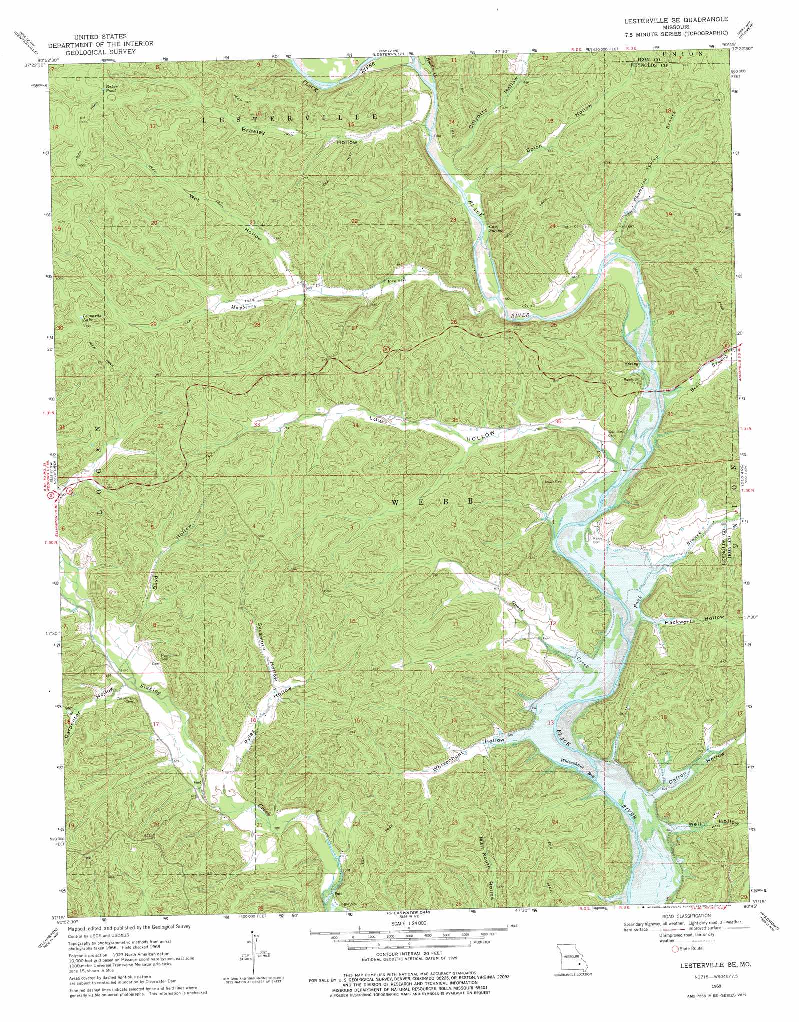
Lesterville Se Topo Map Missouri
To zoom in, hover over the map of Lesterville Se
USGS Topo Quad 37090c7 - 1:24,000 scale
| Topo Map Name: | Lesterville Se |
| USGS Topo Quad ID: | 37090c7 |
| Print Size: | ca. 21 1/4" wide x 27" high |
| Southeast Coordinates: | 37.25° N latitude / 90.75° W longitude |
| Map Center Coordinates: | 37.3125° N latitude / 90.8125° W longitude |
| U.S. State: | MO |
| Filename: | o37090c7.jpg |
| Download Map JPG Image: | Lesterville Se topo map 1:24,000 scale |
| Map Type: | Topographic |
| Topo Series: | 7.5´ |
| Map Scale: | 1:24,000 |
| Source of Map Images: | United States Geological Survey (USGS) |
| Alternate Map Versions: |
Lesterville SE MO 1969, updated 1971 Download PDF Buy paper map Lesterville SE MO 2011 Download PDF Buy paper map Lesterville SE MO 2015 Download PDF Buy paper map |
1:24,000 Topo Quads surrounding Lesterville Se
Oates |
Edgehill |
Johnson Shut-Ins |
Ironton |
Lake Killarney |
Corridon |
Centerville |
Lesterville |
Glover |
Des Arc Ne |
Corridon Se |
Redford |
Lesterville Se |
Des Arc |
Brunot |
Exchange |
Ellington |
Clearwater Dam |
Piedmont |
Patterson |
Van Buren North |
Garwood |
Ellington Se |
Mill Spring |
Piedmont Se |
> Back to 37090a1 at 1:100,000 scale
> Back to 37090a1 at 1:250,000 scale
> Back to U.S. Topo Maps home
Lesterville Se topo map: Gazetteer
Lesterville Se: Bays
Whizenhunt Bay elevation 161m 528′Lesterville Se: Lakes
Baker Pond elevation 328m 1076′Leonards Lake elevation 301m 987′
Lesterville Se: Parks
Highway K Public Use Area elevation 172m 564′Lesterville Se: Post Offices
Martha Post Office (historical) elevation 190m 623′Lesterville Se: Springs
Cave Spring elevation 181m 593′Lesterville Se: Streams
Bear Branch elevation 170m 557′Champion Spring Branch elevation 175m 574′
Funk Branch elevation 163m 534′
Goose Creek elevation 160m 524′
Hyatts Creek elevation 179m 587′
Mayberry Branch elevation 176m 577′
Lesterville Se: Valleys
Bolch Hollow elevation 180m 590′Boyd Hollow elevation 197m 646′
Brawley Hollow elevation 181m 593′
Carpenter Hollow elevation 193m 633′
Colyotte Hollow elevation 182m 597′
Dafron Hollow elevation 161m 528′
Hackworth Hollow elevation 165m 541′
Low Hollow elevation 171m 561′
Pyles Hollow elevation 185m 606′
Pyrtle Hollow elevation 200m 656′
Sycamore Hollow elevation 205m 672′
Well Hollow elevation 165m 541′
Wet Hollow elevation 208m 682′
Wet Hollow elevation 205m 672′
Whizenhunt Hollow elevation 163m 534′
Lesterville Se digital topo map on disk
Buy this Lesterville Se topo map showing relief, roads, GPS coordinates and other geographical features, as a high-resolution digital map file on DVD: