Hurricane Topo Map Missouri
To zoom in, hover over the map of Hurricane
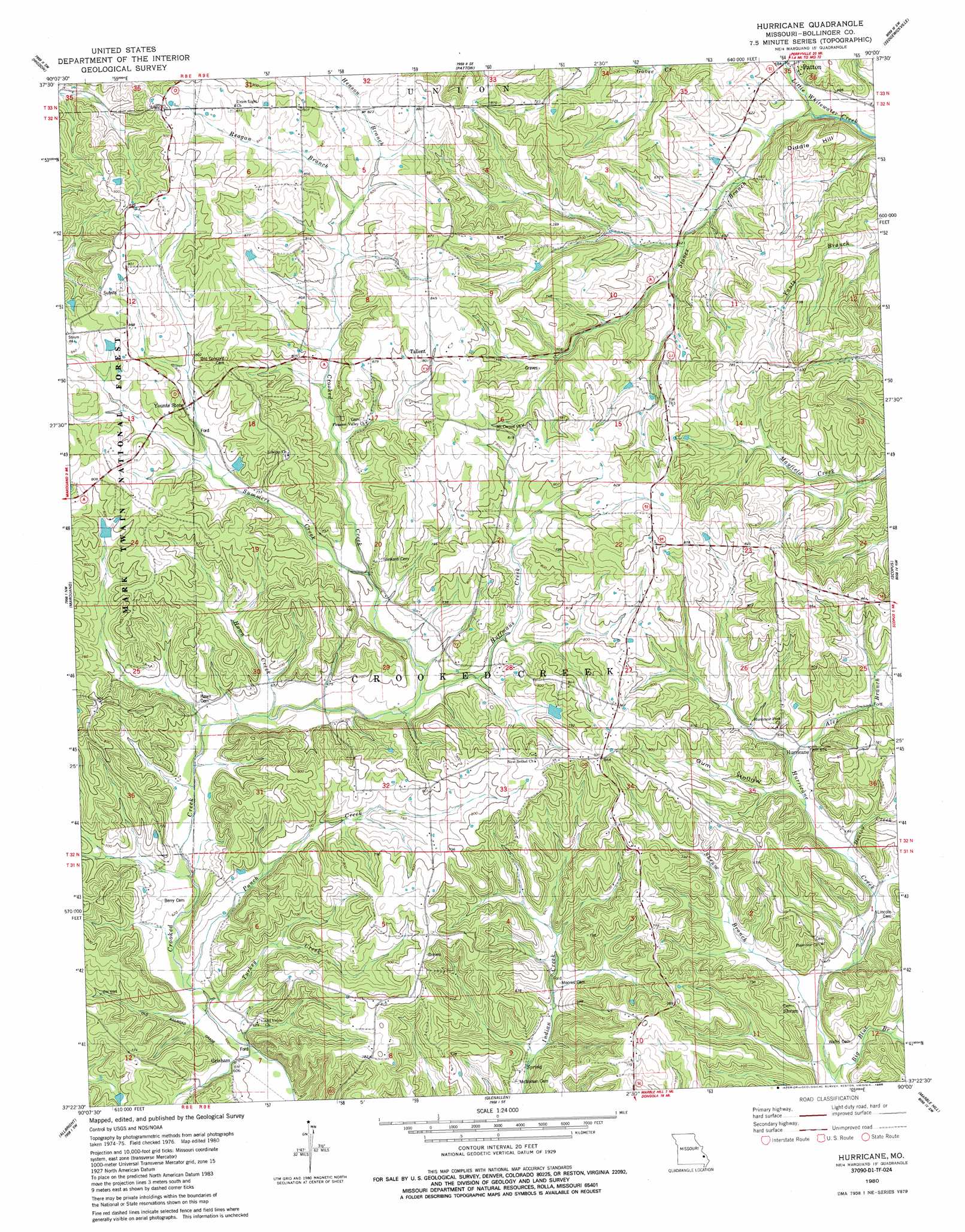
USGS Topo Quad 37090d1 - 1:24,000 scale
| Topo Map Name: | Hurricane |
| USGS Topo Quad ID: | 37090d1 |
| Print Size: | ca. 21 1/4" wide x 27" high |
| Southeast Coordinates: | 37.375° N latitude / 90° W longitude |
| Map Center Coordinates: | 37.4375° N latitude / 90.0625° W longitude |
| U.S. State: | MO |
| Filename: | o37090d1.jpg |
| Download Map JPG Image: | Hurricane topo map 1:24,000 scale |
| Map Type: | Topographic |
| Topo Series: | 7.5´ |
| Map Scale: | 1:24,000 |
| Source of Map Images: | United States Geological Survey (USGS) |
| Alternate Map Versions: |
Hurricane MO 1980, updated 1980 Download PDF Buy paper map Hurricane MO 1980, updated 1986 Download PDF Buy paper map Hurricane MO 2000, updated 2003 Download PDF Buy paper map Hurricane MO 2011 Download PDF Buy paper map Hurricane MO 2015 Download PDF Buy paper map |
| FStopo: | US Forest Service topo Hurricane is available: Download FStopo PDF Download FStopo TIF |
1:24,000 Topo Quads surrounding Hurricane
Knob Lick |
Womack |
Parker Lake |
Perryville West |
Perryville East |
Fredericktown |
Higdon |
Patton |
Sedgewickville |
Friedheim |
Cherokee Pass |
Marquand |
Hurricane |
Scopus |
Millersville |
Cascade |
Allbright |
Glenallen |
Marble Hill |
Bufordville |
Lowndes |
Gipsy |
Zalma |
Dongola |
Whitewater |
> Back to 37090a1 at 1:100,000 scale
> Back to 37090a1 at 1:250,000 scale
> Back to U.S. Topo Maps home
Hurricane topo map: Gazetteer
Hurricane: Dams
Shaw Lake Dam elevation 235m 770′Hurricane: Populated Places
Grisham elevation 184m 603′Hurricane elevation 210m 688′
Loyd elevation 226m 741′
Shrum elevation 179m 587′
Tallent elevation 246m 807′
Hurricane: Post Offices
Loyd Post Office (historical) elevation 226m 741′Hurricane: Reservoirs
Shaw Lake elevation 235m 770′Hurricane: Streams
Alex Branch elevation 199m 652′Big Blue Branch elevation 167m 547′
Denton Creek elevation 189m 620′
Goose Creek elevation 171m 561′
Hawn Creek elevation 197m 646′
Henson Branch elevation 238m 780′
Huffmans Creek elevation 204m 669′
Punch Creek elevation 183m 600′
Reagan Branch elevation 238m 780′
Shrum Branch elevation 173m 567′
Stones Branch elevation 170m 557′
Summers Creek elevation 212m 695′
Turkey Creek elevation 185m 606′
Turkey Creek elevation 183m 600′
Hurricane: Summits
Diddle Hill elevation 228m 748′Hurricane: Valleys
Gum Hollow elevation 196m 643′Hurricane digital topo map on disk
Buy this Hurricane topo map showing relief, roads, GPS coordinates and other geographical features, as a high-resolution digital map file on DVD: