Cherokee Pass Topo Map Missouri
To zoom in, hover over the map of Cherokee Pass
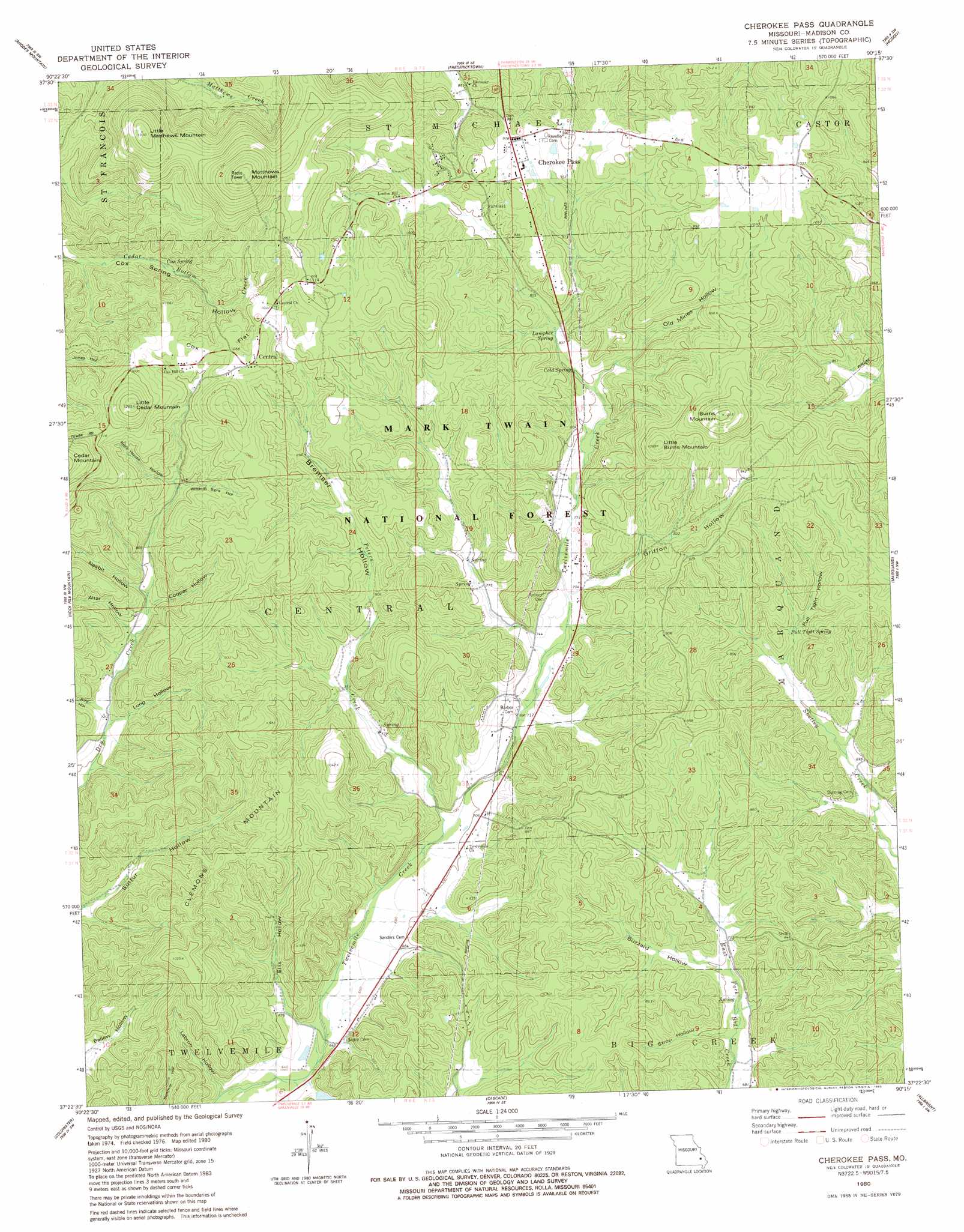
USGS Topo Quad 37090d3 - 1:24,000 scale
| Topo Map Name: | Cherokee Pass |
| USGS Topo Quad ID: | 37090d3 |
| Print Size: | ca. 21 1/4" wide x 27" high |
| Southeast Coordinates: | 37.375° N latitude / 90.25° W longitude |
| Map Center Coordinates: | 37.4375° N latitude / 90.3125° W longitude |
| U.S. State: | MO |
| Filename: | o37090d3.jpg |
| Download Map JPG Image: | Cherokee Pass topo map 1:24,000 scale |
| Map Type: | Topographic |
| Topo Series: | 7.5´ |
| Map Scale: | 1:24,000 |
| Source of Map Images: | United States Geological Survey (USGS) |
| Alternate Map Versions: |
Cherokee Pass MO 1980, updated 1980 Download PDF Buy paper map Cherokee Pass MO 2000, updated 2003 Download PDF Buy paper map Cherokee Pass MO 2011 Download PDF Buy paper map Cherokee Pass MO 2015 Download PDF Buy paper map |
| FStopo: | US Forest Service topo Cherokee Pass is available: Download FStopo PDF Download FStopo TIF |
1:24,000 Topo Quads surrounding Cherokee Pass
Iron Mountain Lake |
Wachita Mountain |
Knob Lick |
Womack |
Parker Lake |
Lake Killarney |
Rhodes Mountain |
Fredericktown |
Higdon |
Patton |
Des Arc Ne |
Rock Pile Mountain |
Cherokee Pass |
Marquand |
Hurricane |
Brunot |
Coldwater |
Cascade |
Allbright |
Glenallen |
Patterson |
Greenville |
Lowndes |
Gipsy |
Zalma |
> Back to 37090a1 at 1:100,000 scale
> Back to 37090a1 at 1:250,000 scale
> Back to U.S. Topo Maps home
Cherokee Pass topo map: Gazetteer
Cherokee Pass: Dams
Whitehurst Lake Dam elevation 215m 705′Cherokee Pass: Flats
Cox Flat elevation 321m 1053′Cherokee Pass: Populated Places
Central elevation 325m 1066′Cherokee Pass elevation 298m 977′
Zion elevation 225m 738′
Cherokee Pass: Reservoirs
Whitehurst Lake elevation 215m 705′Cherokee Pass: Springs
Cold Spring elevation 244m 800′Cox Spring elevation 262m 859′
Lampher Spring elevation 254m 833′
Pull Tight Spring elevation 235m 770′
Cherokee Pass: Streams
Peters Creek elevation 207m 679′Cherokee Pass: Summits
Burns Mountain elevation 368m 1207′Clemons Mountain elevation 318m 1043′
Little Burns Mountain elevation 369m 1210′
Little Cedar Mountain elevation 377m 1236′
Little Matthews Mountain elevation 405m 1328′
Matthews Mountain elevation 434m 1423′
Cherokee Pass: Valleys
Altar Hollow elevation 230m 754′Bremser Hollow elevation 207m 679′
Buzzard Hollow elevation 209m 685′
Cooper Hollow elevation 235m 770′
Ellis Hollow elevation 215m 705′
Griffon Hollow elevation 225m 738′
Jury Hollow elevation 220m 721′
Labron Hollow elevation 188m 616′
Long Hollow elevation 217m 711′
Nesbit Hollow elevation 236m 774′
Old Mines Hollow elevation 240m 787′
Pull Tight Hollow elevation 220m 721′
Rock House Hollow elevation 263m 862′
Strop Hollow elevation 201m 659′
Wildcat Springs Hollow elevation 261m 856′
Cherokee Pass digital topo map on disk
Buy this Cherokee Pass topo map showing relief, roads, GPS coordinates and other geographical features, as a high-resolution digital map file on DVD: