Des Arc Ne Topo Map Missouri
To zoom in, hover over the map of Des Arc Ne
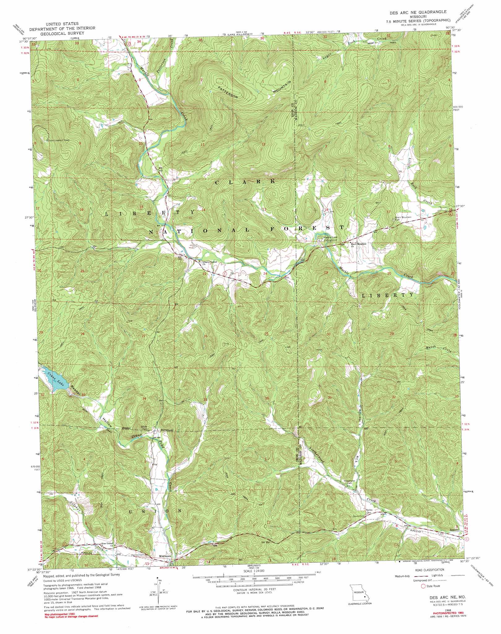
USGS Topo Quad 37090d5 - 1:24,000 scale
| Topo Map Name: | Des Arc Ne |
| USGS Topo Quad ID: | 37090d5 |
| Print Size: | ca. 21 1/4" wide x 27" high |
| Southeast Coordinates: | 37.375° N latitude / 90.5° W longitude |
| Map Center Coordinates: | 37.4375° N latitude / 90.5625° W longitude |
| U.S. State: | MO |
| Filename: | o37090d5.jpg |
| Download Map JPG Image: | Des Arc Ne topo map 1:24,000 scale |
| Map Type: | Topographic |
| Topo Series: | 7.5´ |
| Map Scale: | 1:24,000 |
| Source of Map Images: | United States Geological Survey (USGS) |
| Alternate Map Versions: |
Des Arc NE MO 1968, updated 1969 Download PDF Buy paper map Des Arc NE MO 1968, updated 1969 Download PDF Buy paper map Des Arc NE MO 2000, updated 2003 Download PDF Buy paper map Des Arc NE MO 2011 Download PDF Buy paper map Des Arc NE MO 2015 Download PDF Buy paper map |
| FStopo: | US Forest Service topo Des Arc NE is available: Download FStopo PDF Download FStopo TIF |
1:24,000 Topo Quads surrounding Des Arc Ne
Banner |
Graniteville |
Iron Mountain Lake |
Wachita Mountain |
Knob Lick |
Johnson Shut-Ins |
Ironton |
Lake Killarney |
Rhodes Mountain |
Fredericktown |
Lesterville |
Glover |
Des Arc Ne |
Rock Pile Mountain |
Cherokee Pass |
Lesterville Se |
Des Arc |
Brunot |
Coldwater |
Cascade |
Clearwater Dam |
Piedmont |
Patterson |
Greenville |
Lowndes |
> Back to 37090a1 at 1:100,000 scale
> Back to 37090a1 at 1:250,000 scale
> Back to U.S. Topo Maps home
Des Arc Ne topo map: Gazetteer
Des Arc Ne: Dams
Crane Lake Dam elevation 261m 856′Des Arc Ne: Populated Places
Jewett elevation 159m 521′Minimum elevation 185m 606′
Des Arc Ne: Reservoirs
Crane Lake elevation 261m 856′Des Arc Ne: Streams
Orr Hollow Creek elevation 213m 698′Patterson Creek elevation 243m 797′
Des Arc Ne: Summits
Patterson Mountain elevation 459m 1505′Des Arc Ne: Trails
Crane Lake Trail elevation 261m 856′Des Arc Ne: Valleys
Reader Hollow elevation 203m 666′Tilk Hollow elevation 183m 600′
White Hollow elevation 211m 692′
Des Arc Ne digital topo map on disk
Buy this Des Arc Ne topo map showing relief, roads, GPS coordinates and other geographical features, as a high-resolution digital map file on DVD: