Wachita Mountain Topo Map Missouri
To zoom in, hover over the map of Wachita Mountain
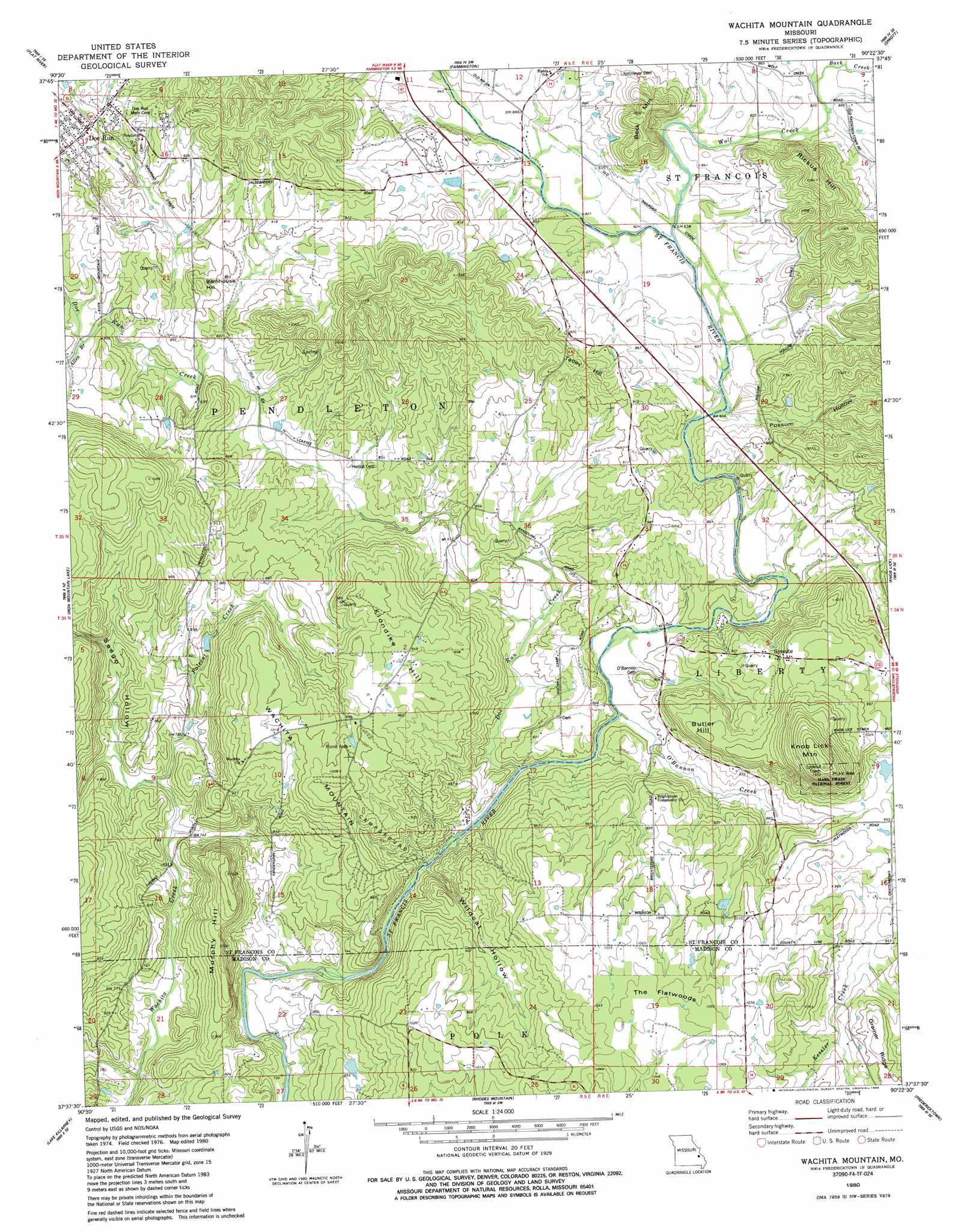
USGS Topo Quad 37090f4 - 1:24,000 scale
| Topo Map Name: | Wachita Mountain |
| USGS Topo Quad ID: | 37090f4 |
| Print Size: | ca. 21 1/4" wide x 27" high |
| Southeast Coordinates: | 37.625° N latitude / 90.375° W longitude |
| Map Center Coordinates: | 37.6875° N latitude / 90.4375° W longitude |
| U.S. State: | MO |
| Filename: | o37090f4.jpg |
| Download Map JPG Image: | Wachita Mountain topo map 1:24,000 scale |
| Map Type: | Topographic |
| Topo Series: | 7.5´ |
| Map Scale: | 1:24,000 |
| Source of Map Images: | United States Geological Survey (USGS) |
| Alternate Map Versions: |
Wachita Mountain MO 1980, updated 1980 Download PDF Buy paper map Wachita Mountain MO 1980, updated 1986 Download PDF Buy paper map Wachita Mountain MO 2011 Download PDF Buy paper map Wachita Mountain MO 2015 Download PDF Buy paper map |
1:24,000 Topo Quads surrounding Wachita Mountain
Mineral Point |
Bonne Terre |
French Village |
Lawrenceton |
Weingarten |
Irondale |
Flat River |
Farmington |
Sprott |
Coffman |
Graniteville |
Iron Mountain Lake |
Wachita Mountain |
Knob Lick |
Womack |
Ironton |
Lake Killarney |
Rhodes Mountain |
Fredericktown |
Higdon |
Glover |
Des Arc Ne |
Rock Pile Mountain |
Cherokee Pass |
Marquand |
> Back to 37090e1 at 1:100,000 scale
> Back to 37090a1 at 1:250,000 scale
> Back to U.S. Topo Maps home
Wachita Mountain topo map: Gazetteer
Wachita Mountain: Dams
Mononame 662 Dam elevation 255m 836′Mononame 826 Dam elevation 281m 921′
Shannon Dam elevation 253m 830′
Wachita Mountain: Flats
Black Oak Flat elevation 300m 984′Wachita Mountain: Forests
Fredericktown Ranger District elevation 327m 1072′Wachita Mountain: Gaps
The Flatwoods elevation 325m 1066′Wachita Mountain: Mines
Alexander and Burks Granite Quarry (historical) elevation 273m 895′Asplof Granite Quarry elevation 342m 1122′
Hill-O'Mera Construction Company Granite Quarry elevation 262m 859′
Milne and Gordon Granite Quarry elevation 245m 803′
Missouri Granite Construction Company Quarry (historical) elevation 292m 958′
Zeran Gregory Granite Company Quarry (historical) elevation 256m 839′
Wachita Mountain: Populated Places
Doe Run elevation 282m 925′Hamilton Town elevation 283m 928′
Syenite elevation 299m 980′
Wachita Mountain: Reservoirs
Limel Lake elevation 253m 830′Wachita Mountain: Streams
Allen Branch elevation 264m 866′Back Creek elevation 253m 830′
Brewers Creek elevation 219m 718′
Doe Run Creek elevation 232m 761′
Lick Branch elevation 252m 826′
O'Bannon Creek elevation 238m 780′
Polecat Creek elevation 225m 738′
Wildcat Creek elevation 224m 734′
Wolf Creek elevation 249m 816′
Wachita Mountain: Summits
Barnhouse Hill elevation 288m 944′Beck Mountain elevation 317m 1040′
Butler Hill elevation 306m 1003′
Gruner Hill elevation 343m 1125′
Klondike Hill elevation 311m 1020′
Knob Lick Mountain elevation 400m 1312′
Murphy Hill elevation 311m 1020′
Rickus Hill elevation 329m 1079′
Tetley Hill elevation 300m 984′
Wachita Mountain elevation 312m 1023′
Wachita Mountain: Valleys
Pinnacle Hollow elevation 225m 738′Possum Hollow elevation 246m 807′
Seego Hollow elevation 224m 734′
Wildcat Hollow elevation 234m 767′
Wachita Mountain digital topo map on disk
Buy this Wachita Mountain topo map showing relief, roads, GPS coordinates and other geographical features, as a high-resolution digital map file on DVD: