Iron Mountain Lake Topo Map Missouri
To zoom in, hover over the map of Iron Mountain Lake
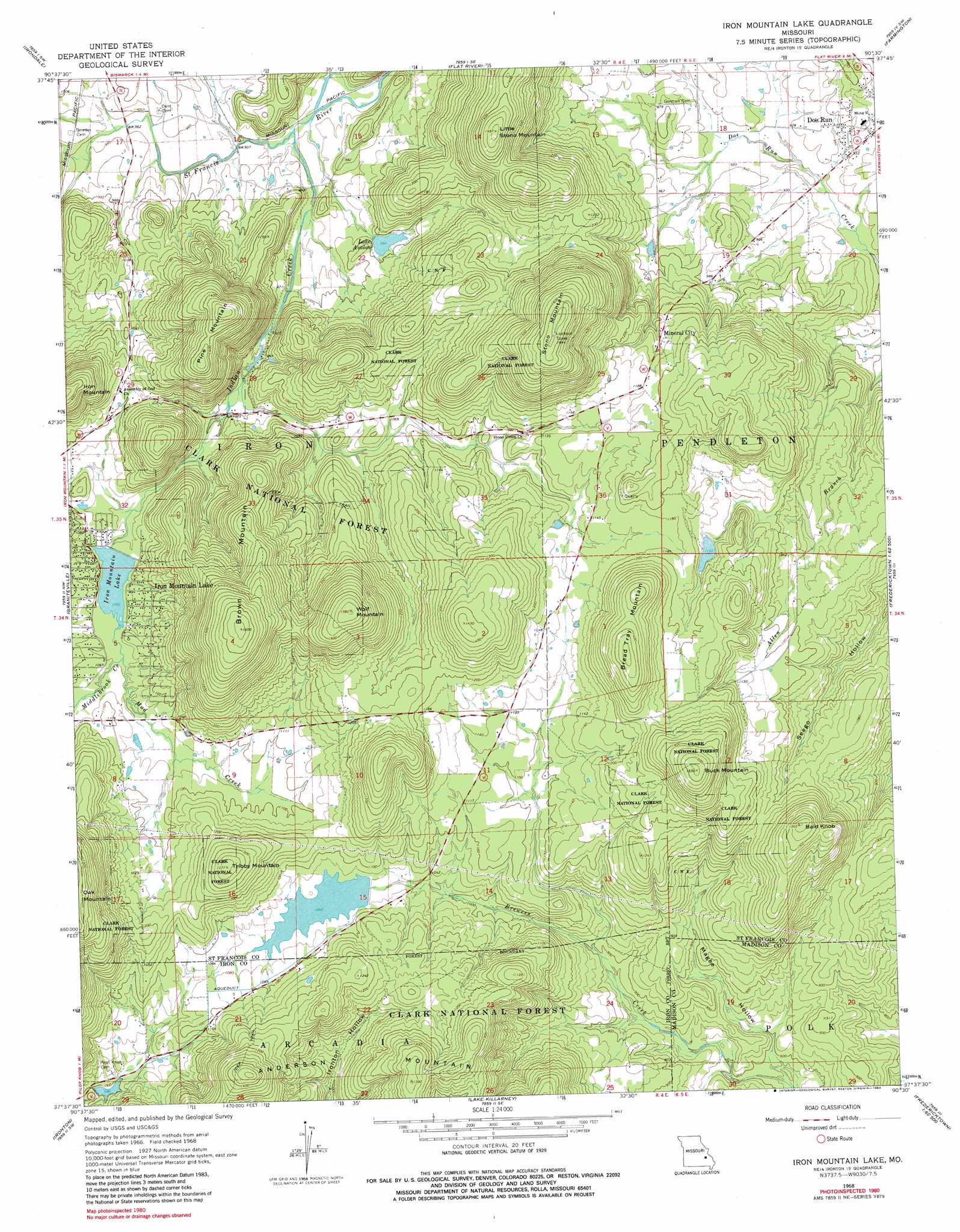
USGS Topo Quad 37090f5 - 1:24,000 scale
| Topo Map Name: | Iron Mountain Lake |
| USGS Topo Quad ID: | 37090f5 |
| Print Size: | ca. 21 1/4" wide x 27" high |
| Southeast Coordinates: | 37.625° N latitude / 90.5° W longitude |
| Map Center Coordinates: | 37.6875° N latitude / 90.5625° W longitude |
| U.S. State: | MO |
| Filename: | o37090f5.jpg |
| Download Map JPG Image: | Iron Mountain Lake topo map 1:24,000 scale |
| Map Type: | Topographic |
| Topo Series: | 7.5´ |
| Map Scale: | 1:24,000 |
| Source of Map Images: | United States Geological Survey (USGS) |
| Alternate Map Versions: |
Iron Mountain Lake MO 1968, updated 1970 Download PDF Buy paper map Iron Mountain Lake MO 1968, updated 1983 Download PDF Buy paper map Iron Mountain Lake MO 2000, updated 2003 Download PDF Buy paper map Iron Mountain Lake MO 2011 Download PDF Buy paper map Iron Mountain Lake MO 2015 Download PDF Buy paper map |
| FStopo: | US Forest Service topo Iron Mountain Lake is available: Download FStopo PDF Download FStopo TIF |
1:24,000 Topo Quads surrounding Iron Mountain Lake
Potosi |
Mineral Point |
Bonne Terre |
French Village |
Lawrenceton |
Belgrade |
Irondale |
Flat River |
Farmington |
Sprott |
Banner |
Graniteville |
Iron Mountain Lake |
Wachita Mountain |
Knob Lick |
Johnson Shut-Ins |
Ironton |
Lake Killarney |
Rhodes Mountain |
Fredericktown |
Lesterville |
Glover |
Des Arc Ne |
Rock Pile Mountain |
Cherokee Pass |
> Back to 37090e1 at 1:100,000 scale
> Back to 37090a1 at 1:250,000 scale
> Back to U.S. Topo Maps home
Iron Mountain Lake topo map: Gazetteer
Iron Mountain Lake: Airports
Dove Airstrip elevation 325m 1066′Iron Mountain Lake: Dams
Iron Mountain Lake Dam elevation 320m 1049′Lake 2 Dam elevation 304m 997′
Lake Avalon Dam elevation 302m 990′
Lake Number 1 Dam elevation 323m 1059′
Sylvan Lake Dam elevation 348m 1141′
Iron Mountain Lake: Mines
Doe Run Lead Mines elevation 292m 958′Iron Mountain Lake: Populated Places
Iron Mountain Lake elevation 322m 1056′Mineral City elevation 346m 1135′
Iron Mountain Lake: Reservoirs
Iron Mountain Lake elevation 320m 1049′Lake Avalon elevation 302m 990′
Pilot Knob Lake elevation 323m 1059′
Pilot Knob Pellet Company Lake Number 2 elevation 304m 997′
S G Powell Lake elevation 348m 1141′
Iron Mountain Lake: Streams
Indian Creek elevation 284m 931′Middlebrook Creek elevation 322m 1056′
Mud Creek elevation 322m 1056′
White Creek elevation 299m 980′
Iron Mountain Lake: Summits
Anderson Mountain elevation 447m 1466′Bald Knob elevation 415m 1361′
Bread Tray Mountain elevation 440m 1443′
Brown Mountain elevation 502m 1646′
Buck Mountain elevation 466m 1528′
Little Stono Mountain elevation 443m 1453′
Pine Mountain elevation 452m 1482′
Rocky Knob elevation 403m 1322′
Stono Mountain elevation 499m 1637′
Tribby Mountain elevation 418m 1371′
Wolf Mountain elevation 481m 1578′
Iron Mountain Lake: Valleys
Magee Hollow elevation 239m 784′South Spring Hollow elevation 302m 990′
Iron Mountain Lake digital topo map on disk
Buy this Iron Mountain Lake topo map showing relief, roads, GPS coordinates and other geographical features, as a high-resolution digital map file on DVD: