Graniteville Topo Map Missouri
To zoom in, hover over the map of Graniteville
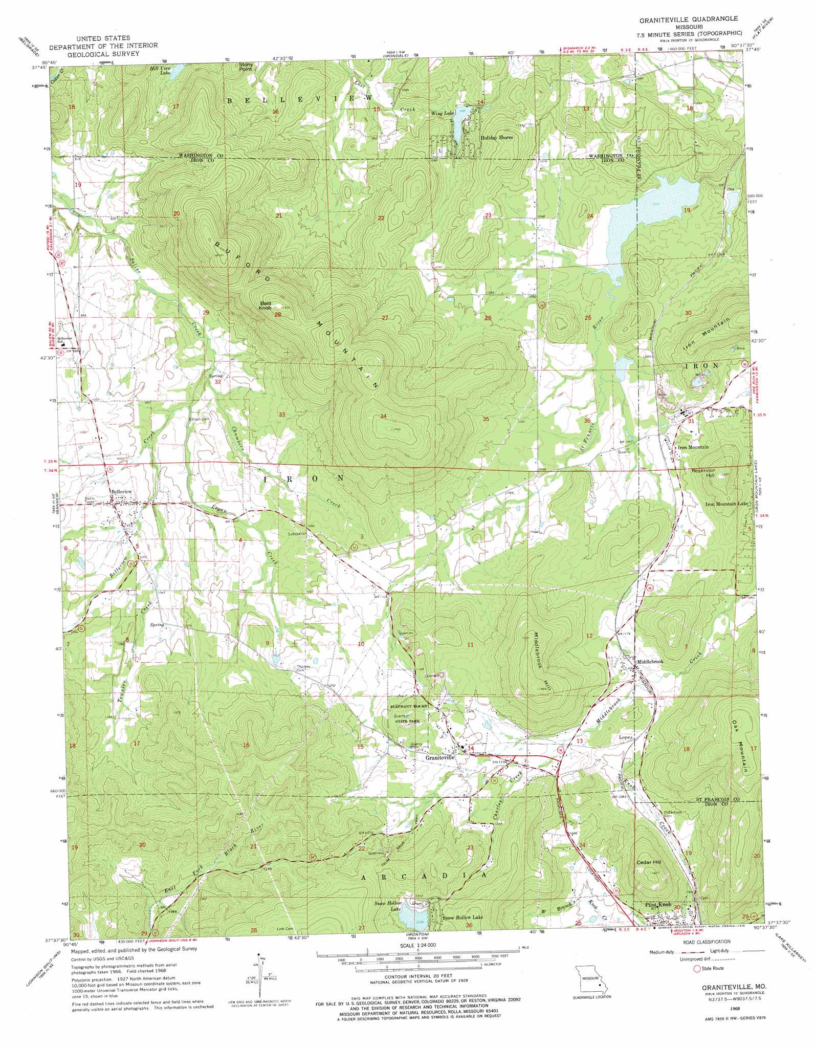
USGS Topo Quad 37090f6 - 1:24,000 scale
| Topo Map Name: | Graniteville |
| USGS Topo Quad ID: | 37090f6 |
| Print Size: | ca. 21 1/4" wide x 27" high |
| Southeast Coordinates: | 37.625° N latitude / 90.625° W longitude |
| Map Center Coordinates: | 37.6875° N latitude / 90.6875° W longitude |
| U.S. State: | MO |
| Filename: | o37090f6.jpg |
| Download Map JPG Image: | Graniteville topo map 1:24,000 scale |
| Map Type: | Topographic |
| Topo Series: | 7.5´ |
| Map Scale: | 1:24,000 |
| Source of Map Images: | United States Geological Survey (USGS) |
| Alternate Map Versions: |
Graniteville MO 1968, updated 1970 Download PDF Buy paper map Graniteville MO 1968, updated 1978 Download PDF Buy paper map Graniteville MO 2011 Download PDF Buy paper map Graniteville MO 2015 Download PDF Buy paper map |
1:24,000 Topo Quads surrounding Graniteville
Shirley |
Potosi |
Mineral Point |
Bonne Terre |
French Village |
Palmer |
Belgrade |
Irondale |
Flat River |
Farmington |
Johnson Mountain |
Banner |
Graniteville |
Iron Mountain Lake |
Wachita Mountain |
Edgehill |
Johnson Shut-Ins |
Ironton |
Lake Killarney |
Rhodes Mountain |
Centerville |
Lesterville |
Glover |
Des Arc Ne |
Rock Pile Mountain |
> Back to 37090e1 at 1:100,000 scale
> Back to 37090a1 at 1:250,000 scale
> Back to U.S. Topo Maps home
Graniteville topo map: Gazetteer
Graniteville: Airports
Sky Ranch II Airport elevation 317m 1040′Graniteville: Dams
Black Lower Lake Dam elevation 299m 980′Black Upper Lake Dam elevation 320m 1049′
Hematite Lake Dam elevation 313m 1026′
Iron Mountain Tailings Pond Dam elevation 319m 1046′
Snow Hollow Dam elevation 390m 1279′
Wing Lake Dam elevation 301m 987′
Graniteville: Mines
Cedar Hill Iron Mine elevation 345m 1131′Phil Schneider Granite Quarries elevation 354m 1161′
Pilot Knob Granite Quarry elevation 433m 1420′
Schneider Companys Quarry elevation 354m 1161′
Sheahan Brothers Granite Quarry elevation 371m 1217′
Syenite Granite Companys Quarry elevation 365m 1197′
Graniteville: Parks
Elephant Rocks State Park elevation 391m 1282′Graniteville: Populated Places
Belleview elevation 319m 1046′Ghermanville elevation 361m 1184′
Graniteville elevation 369m 1210′
Holiday Shores elevation 307m 1007′
Iron Mountain elevation 329m 1079′
Lopez elevation 345m 1131′
Middlebrook elevation 344m 1128′
Pin Hook elevation 323m 1059′
Snow Hollow Lake elevation 396m 1299′
Graniteville: Reservoirs
Hemitite Lake elevation 313m 1026′Hill View Lake elevation 273m 895′
Iron Mountain Tailings Pond elevation 319m 1046′
Ozark Ore Company Lake elevation 312m 1023′
Snow Hollow Lake elevation 390m 1279′
Wing Lake elevation 301m 987′
Graniteville: Streams
Belleview Creek elevation 287m 941′Chambers Creek elevation 287m 941′
Charles Creek elevation 349m 1145′
First Creek elevation 313m 1026′
Logan Creek elevation 288m 944′
Townsen Creek elevation 304m 997′
Graniteville: Summits
Bald Knob elevation 479m 1571′Buford Mountain elevation 531m 1742′
Buzzards Roost elevation 377m 1236′
Cedar Hill elevation 434m 1423′
Iron Mountain elevation 441m 1446′
Little Iron Mountain elevation 409m 1341′
Middlebrook Hill elevation 477m 1564′
Oak Mountain elevation 495m 1624′
Reservoir Hill elevation 425m 1394′
Stony Point elevation 330m 1082′
Graniteville digital topo map on disk
Buy this Graniteville topo map showing relief, roads, GPS coordinates and other geographical features, as a high-resolution digital map file on DVD: