Minnith Topo Map Missouri
To zoom in, hover over the map of Minnith
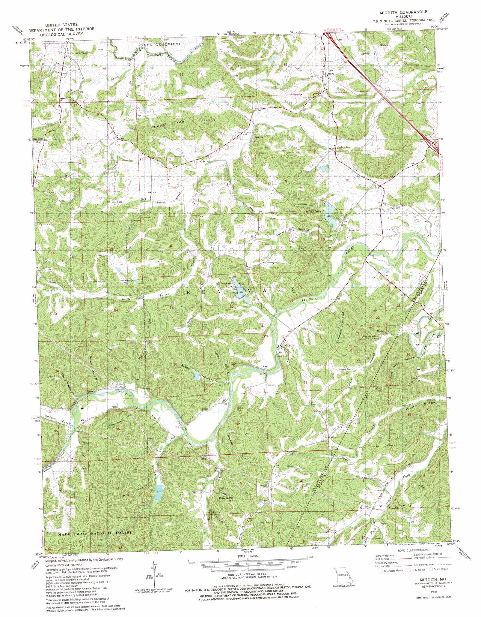
USGS Topo Quad 37090g1 - 1:24,000 scale
| Topo Map Name: | Minnith |
| USGS Topo Quad ID: | 37090g1 |
| Print Size: | ca. 21 1/4" wide x 27" high |
| Southeast Coordinates: | 37.75° N latitude / 90° W longitude |
| Map Center Coordinates: | 37.8125° N latitude / 90.0625° W longitude |
| U.S. State: | MO |
| Filename: | o37090g1.jpg |
| Download Map JPG Image: | Minnith topo map 1:24,000 scale |
| Map Type: | Topographic |
| Topo Series: | 7.5´ |
| Map Scale: | 1:24,000 |
| Source of Map Images: | United States Geological Survey (USGS) |
| Alternate Map Versions: |
Minnith MO 1980, updated 1980 Download PDF Buy paper map Minnith MO 2000, updated 2002 Download PDF Buy paper map Minnith MO 2011 Download PDF Buy paper map Minnith MO 2015 Download PDF Buy paper map |
| FStopo: | US Forest Service topo Minnith is available: Download FStopo PDF Download FStopo TIF |
1:24,000 Topo Quads surrounding Minnith
Danby |
Bloomsdale |
Prairie Du Rocher |
Evansville |
Walsh |
Lawrenceton |
Weingarten |
Sainte Genevieve |
Kaskaskia |
Chester |
Sprott |
Coffman |
Minnith |
Lithium |
Belgique |
Knob Lick |
Womack |
Parker Lake |
Perryville West |
Perryville East |
Fredericktown |
Higdon |
Patton |
Sedgewickville |
Friedheim |
> Back to 37090e1 at 1:100,000 scale
> Back to 37090a1 at 1:250,000 scale
> Back to U.S. Topo Maps home
Minnith topo map: Gazetteer
Minnith: Dams
Absher Lake Dam elevation 134m 439′Donze Lake Dam elevation 141m 462′
Foerster Dam elevation 152m 498′
Giesler Lake Dam elevation 170m 557′
Giesler Lake Dam elevation 181m 593′
Glen Basler Lake Dam elevation 163m 534′
Hudson Lake Dam elevation 146m 479′
Kisco Dam elevation 139m 456′
Lake Minnie Ha-Ha Lower Dam elevation 143m 469′
Lake Minnie Ha-Ha Upper Dam elevation 151m 495′
Salt Petre Dam elevation 195m 639′
Minnith: Mines
Ozora Marble Quarries elevation 139m 456′Minnith: Populated Places
Minnith elevation 135m 442′Ozora elevation 164m 538′
River aux Vases elevation 137m 449′
Minnith: Reservoirs
Donze Lake elevation 141m 462′Foerster Lake elevation 152m 498′
Kisco Lake elevation 139m 456′
Lake Minnie Ha-Ha Lower elevation 143m 469′
Lake Minnie Ha-Ha Upper elevation 151m 495′
Minnehaha Lake elevation 150m 492′
Salt Petre Lake elevation 195m 639′
Minnith: Ridges
Peach Tree Ridge elevation 176m 577′Minnith: Streams
Brushy Creek elevation 134m 439′Dry Fork elevation 150m 492′
Dry Saline Creek elevation 146m 479′
Johns Creek elevation 134m 439′
Madden Creek elevation 146m 479′
Mill Creek elevation 122m 400′
Saline Creek elevation 145m 475′
South Fork Saline Creek elevation 116m 380′
Tube Branch elevation 122m 400′
Voelker Branch elevation 116m 380′
Walnut Creek elevation 130m 426′
Minnith: Summits
Graveyard Hill elevation 203m 666′High Knoll elevation 204m 669′
Minnith: Valleys
Amos Hollow elevation 133m 436′Bald Glade Hollow elevation 140m 459′
Cottonwood Hollow elevation 130m 426′
Curve Trestle Hollow elevation 145m 475′
Devils Den Hollow elevation 147m 482′
Fish Trap Hollow elevation 118m 387′
Opossum Hollow elevation 143m 469′
Pierce Hollow elevation 133m 436′
Ray Hollow elevation 151m 495′
Schoolhouse Hollow elevation 122m 400′
Swamp Hollow elevation 140m 459′
Turkey Hollow elevation 122m 400′
Minnith digital topo map on disk
Buy this Minnith topo map showing relief, roads, GPS coordinates and other geographical features, as a high-resolution digital map file on DVD: