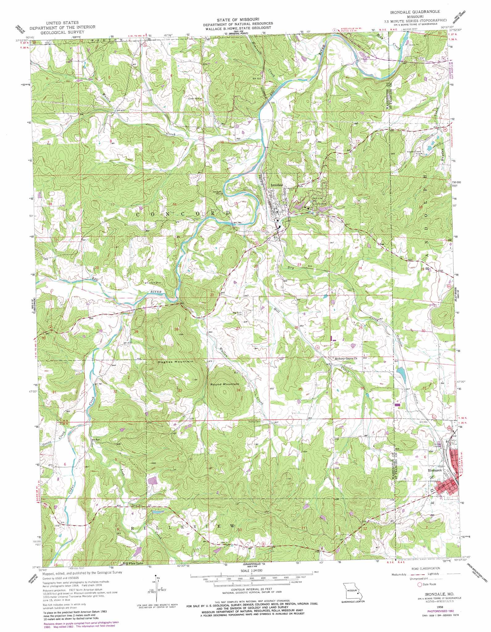
Irondale Topo Map Missouri
To zoom in, hover over the map of Irondale
USGS Topo Quad 37090g6 - 1:24,000 scale
| Topo Map Name: | Irondale |
| USGS Topo Quad ID: | 37090g6 |
| Print Size: | ca. 21 1/4" wide x 27" high |
| Southeast Coordinates: | 37.75° N latitude / 90.625° W longitude |
| Map Center Coordinates: | 37.8125° N latitude / 90.6875° W longitude |
| U.S. State: | MO |
| Filename: | o37090g6.jpg |
| Download Map JPG Image: | Irondale topo map 1:24,000 scale |
| Map Type: | Topographic |
| Topo Series: | 7.5´ |
| Map Scale: | 1:24,000 |
| Source of Map Images: | United States Geological Survey (USGS) |
| Alternate Map Versions: |
Irondale MO 1958, updated 1959 Download PDF Buy paper map Irondale MO 1958, updated 1968 Download PDF Buy paper map Irondale MO 1958, updated 1982 Download PDF Buy paper map Irondale MO 2011 Download PDF Buy paper map Irondale MO 2015 Download PDF Buy paper map |
1:24,000 Topo Quads surrounding Irondale
Ebo |
Old Mines |
Tiff |
Vineland |
Halifax |
Shirley |
Potosi |
Mineral Point |
Bonne Terre |
French Village |
Palmer |
Belgrade |
Irondale |
Flat River |
Farmington |
Johnson Mountain |
Banner |
Graniteville |
Iron Mountain Lake |
Wachita Mountain |
Edgehill |
Johnson Shut-Ins |
Ironton |
Lake Killarney |
Rhodes Mountain |
> Back to 37090e1 at 1:100,000 scale
> Back to 37090a1 at 1:250,000 scale
> Back to U.S. Topo Maps home
Irondale topo map: Gazetteer
Irondale: Dams
Cates Lake Dam elevation 283m 928′Hill View Lake Dam South elevation 267m 875′
Hillview Lake Dam elevation 263m 862′
Lake Apache Dam elevation 258m 846′
Lake Cherokee Dam elevation 271m 889′
Yacovelli Lake Dam elevation 287m 941′
Irondale: Mines
Adams Property elevation 310m 1017′Eaton Iron Bank elevation 243m 797′
Evans Mine elevation 263m 862′
Eversole Mine elevation 244m 800′
Hayden Creek Mine elevation 270m 885′
Irondale Mine elevation 242m 793′
Kirkpatrick Iron Bank elevation 289m 948′
Scott Iron Bank elevation 231m 757′
Scott Iron Bank elevation 251m 823′
Irondale: Populated Places
Irondale elevation 246m 807′Irondale: Reservoirs
Hillview Lake elevation 263m 862′Irondale Lake elevation 230m 754′
Lake Apache elevation 258m 846′
Lake Cherokee elevation 271m 889′
Lake Sacajawea elevation 283m 928′
Irondale: Streams
Blay Creek elevation 225m 738′Cedar Creek elevation 236m 774′
Dry Creek elevation 227m 744′
Goose Creek elevation 243m 797′
Hayden Creek elevation 234m 767′
Hopewell Creek elevation 226m 741′
Hughes Creek elevation 255m 836′
Lost Creek elevation 242m 793′
Mill Creek elevation 230m 754′
Wallen Creek elevation 228m 748′
Wallen Creek elevation 233m 764′
Irondale: Summits
Hughes Mountain elevation 366m 1200′Round Mountain elevation 365m 1197′
Irondale digital topo map on disk
Buy this Irondale topo map showing relief, roads, GPS coordinates and other geographical features, as a high-resolution digital map file on DVD: