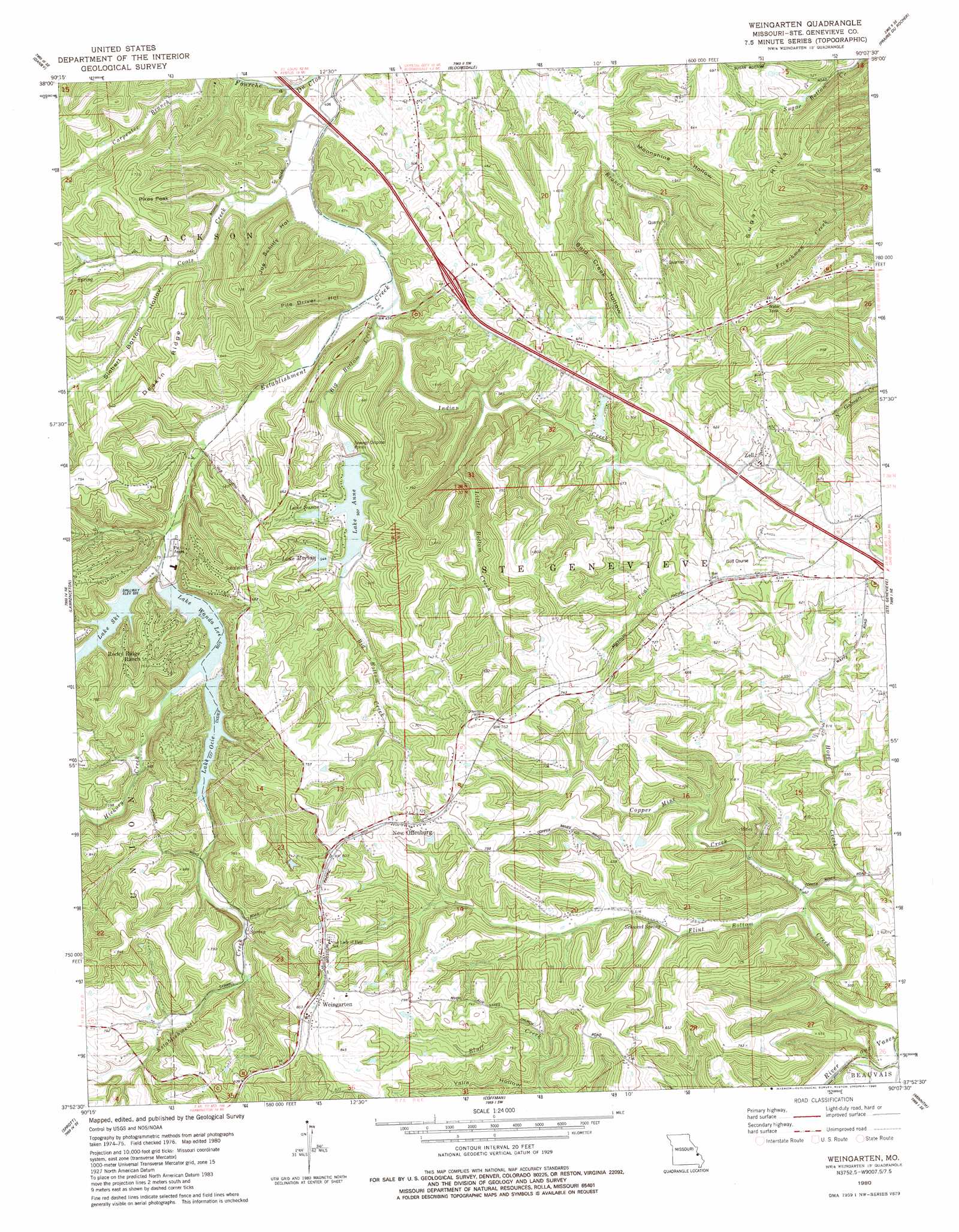
Weingarten Topo Map Missouri
To zoom in, hover over the map of Weingarten
USGS Topo Quad 37090h2 - 1:24,000 scale
| Topo Map Name: | Weingarten |
| USGS Topo Quad ID: | 37090h2 |
| Print Size: | ca. 21 1/4" wide x 27" high |
| Southeast Coordinates: | 37.875° N latitude / 90.125° W longitude |
| Map Center Coordinates: | 37.9375° N latitude / 90.1875° W longitude |
| U.S. State: | MO |
| Filename: | o37090h2.jpg |
| Download Map JPG Image: | Weingarten topo map 1:24,000 scale |
| Map Type: | Topographic |
| Topo Series: | 7.5´ |
| Map Scale: | 1:24,000 |
| Source of Map Images: | United States Geological Survey (USGS) |
| Alternate Map Versions: |
Weingarten MO 1980, updated 1980 Download PDF Buy paper map Weingarten MO 2011 Download PDF Buy paper map Weingarten MO 2015 Download PDF Buy paper map |
1:24,000 Topo Quads surrounding Weingarten
Festus |
Selma |
Renault |
Ames |
Red Bud |
Halifax |
Danby |
Bloomsdale |
Prairie Du Rocher |
Evansville |
French Village |
Lawrenceton |
Weingarten |
Sainte Genevieve |
Kaskaskia |
Farmington |
Sprott |
Coffman |
Minnith |
Lithium |
Wachita Mountain |
Knob Lick |
Womack |
Parker Lake |
Perryville West |
> Back to 37090e1 at 1:100,000 scale
> Back to 37090a1 at 1:250,000 scale
> Back to U.S. Topo Maps home
Weingarten topo map: Gazetteer
Weingarten: Dams
Lake Forest Dam elevation 162m 531′Lake Marian Dam elevation 166m 544′
Lake Ocie Dam elevation 162m 531′
Lake Ski Dam elevation 162m 531′
Lake Susan Dam elevation 165m 541′
Lake Wanda Lee Dam elevation 154m 505′
Weingarten: Mines
Cornwall Copper Mine elevation 166m 544′Weingarten: Populated Places
Copper Mine elevation 154m 505′New Offenburg elevation 232m 761′
Rocky Ridge Ranch elevation 218m 715′
Weingarten elevation 255m 836′
Zell elevation 192m 629′
Weingarten: Ranges
Sugar Hills elevation 244m 800′Weingarten: Reservoirs
Lake Anne elevation 153m 501′Lake Forest elevation 162m 531′
Lake Marian elevation 166m 544′
Lake Ocie elevation 162m 531′
Lake Ski elevation 162m 531′
Lake Susan elevation 165m 541′
Lake Wanda Lee elevation 154m 505′
Weingarten: Ridges
Deakin Ridge elevation 195m 639′Weingarten: Springs
Schwent Spring elevation 153m 501′Weingarten: Streams
Big Bottom Creek elevation 144m 472′Coal Creek elevation 155m 508′
Coots Creek elevation 119m 390′
Copper Mine Creek elevation 135m 442′
Flint Bottom Creek elevation 128m 419′
Hickory Creek elevation 155m 508′
Hogg Creek elevation 136m 446′
Indian Creek elevation 146m 479′
Little Bottom Creek elevation 166m 544′
Weingarten: Summits
Pikes Peak elevation 220m 721′Weingarten: Valleys
Bald Creek Hollow elevation 134m 439′Joe Schilly Hollow elevation 127m 416′
Lick Hollow elevation 181m 593′
Moonshine Hollow elevation 130m 426′
Pile Driver Hollow elevation 127m 416′
Siebert Bottom Hollow elevation 137m 449′
Valle Hollow elevation 163m 534′
Weingarten digital topo map on disk
Buy this Weingarten topo map showing relief, roads, GPS coordinates and other geographical features, as a high-resolution digital map file on DVD: