Lawrenceton Topo Map Missouri
To zoom in, hover over the map of Lawrenceton
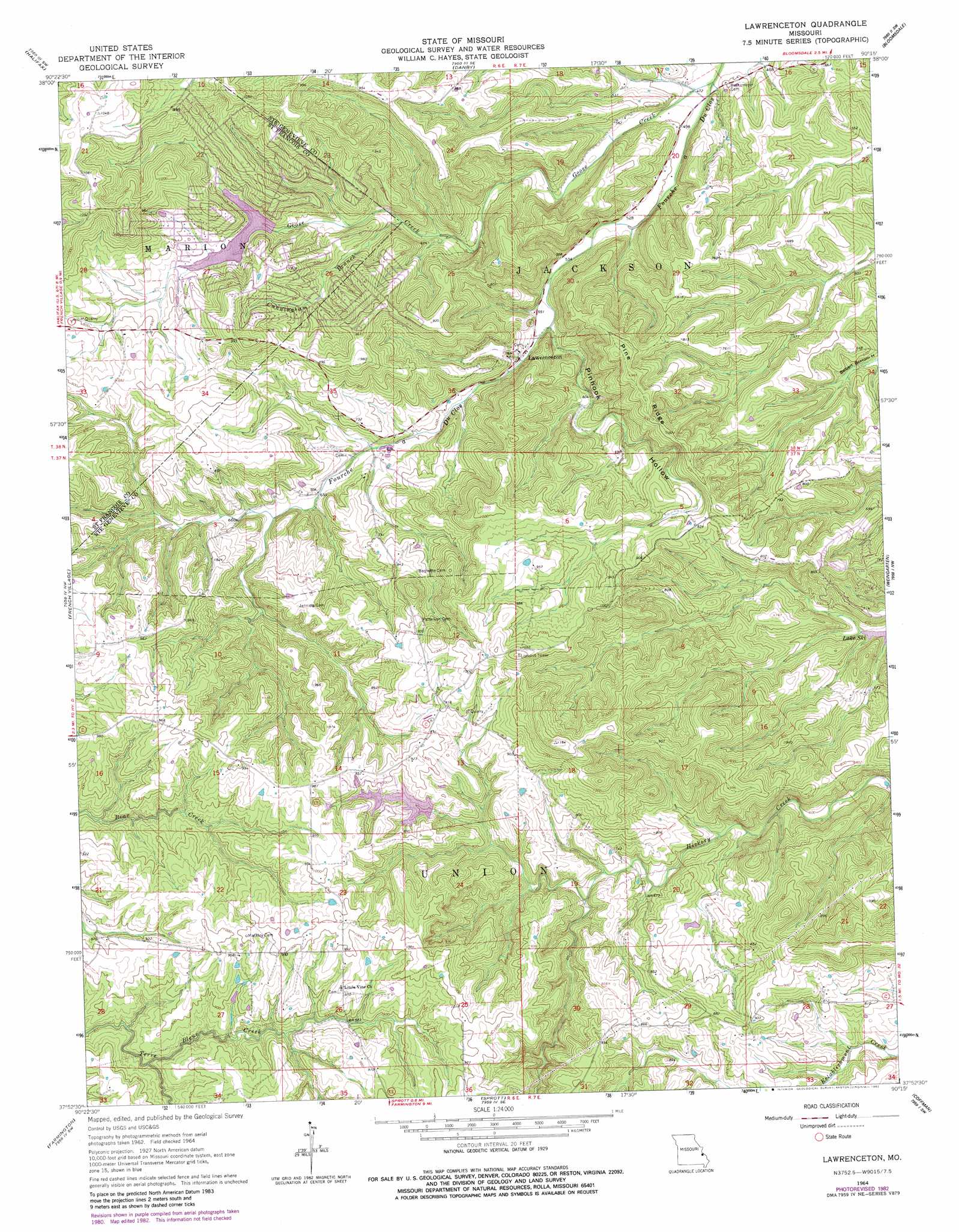
USGS Topo Quad 37090h3 - 1:24,000 scale
| Topo Map Name: | Lawrenceton |
| USGS Topo Quad ID: | 37090h3 |
| Print Size: | ca. 21 1/4" wide x 27" high |
| Southeast Coordinates: | 37.875° N latitude / 90.25° W longitude |
| Map Center Coordinates: | 37.9375° N latitude / 90.3125° W longitude |
| U.S. State: | MO |
| Filename: | o37090h3.jpg |
| Download Map JPG Image: | Lawrenceton topo map 1:24,000 scale |
| Map Type: | Topographic |
| Topo Series: | 7.5´ |
| Map Scale: | 1:24,000 |
| Source of Map Images: | United States Geological Survey (USGS) |
| Alternate Map Versions: |
Lawrenceton MO 1964, updated 1965 Download PDF Buy paper map Lawrenceton MO 1964, updated 1977 Download PDF Buy paper map Lawrenceton MO 1964, updated 1982 Download PDF Buy paper map Lawrenceton MO 2011 Download PDF Buy paper map Lawrenceton MO 2015 Download PDF Buy paper map |
1:24,000 Topo Quads surrounding Lawrenceton
Desoto |
Festus |
Selma |
Renault |
Ames |
Vineland |
Halifax |
Danby |
Bloomsdale |
Prairie Du Rocher |
Bonne Terre |
French Village |
Lawrenceton |
Weingarten |
Sainte Genevieve |
Flat River |
Farmington |
Sprott |
Coffman |
Minnith |
Iron Mountain Lake |
Wachita Mountain |
Knob Lick |
Womack |
Parker Lake |
> Back to 37090e1 at 1:100,000 scale
> Back to 37090a1 at 1:250,000 scale
> Back to U.S. Topo Maps home
Lawrenceton topo map: Gazetteer
Lawrenceton: Dams
Goose Creek Lake Dam elevation 217m 711′Lake Seven Falls Dam Number 2 elevation 259m 849′
Lake Seven Falls Dam Number 3 elevation 243m 797′
Number 615 Dam elevation 271m 889′
Pinkston Dam elevation 213m 698′
Lawrenceton: Populated Places
Lawrenceton elevation 173m 567′Mill elevation 294m 964′
Lawrenceton: Reservoirs
Erb Lake elevation 243m 797′Goose Creek Lake elevation 217m 711′
Pinkston Lake elevation 195m 639′
Pinkston Lake (historical) elevation 213m 698′
Lawrenceton: Ridges
Pine Ridge elevation 294m 964′Lawrenceton: Streams
Cunningham Branch elevation 190m 623′Goose Creek elevation 140m 459′
Pin Hook Branch elevation 164m 538′
Lawrenceton: Summits
Little Vine Hill elevation 299m 980′Lawrenceton: Valleys
Pinhook Hollow elevation 164m 538′Lawrenceton digital topo map on disk
Buy this Lawrenceton topo map showing relief, roads, GPS coordinates and other geographical features, as a high-resolution digital map file on DVD: