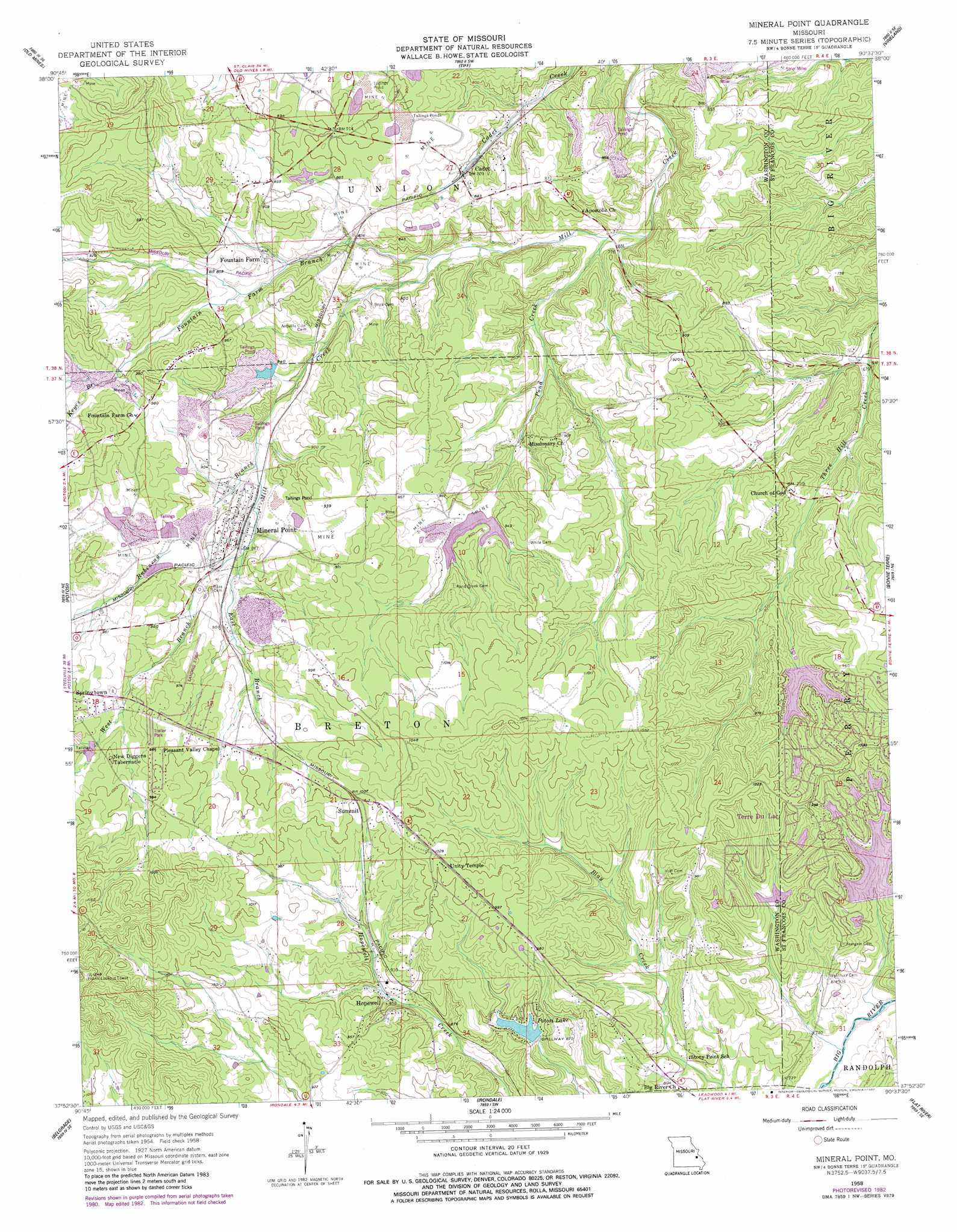
Mineral Point Topo Map Missouri
To zoom in, hover over the map of Mineral Point
USGS Topo Quad 37090h6 - 1:24,000 scale
| Topo Map Name: | Mineral Point |
| USGS Topo Quad ID: | 37090h6 |
| Print Size: | ca. 21 1/4" wide x 27" high |
| Southeast Coordinates: | 37.875° N latitude / 90.625° W longitude |
| Map Center Coordinates: | 37.9375° N latitude / 90.6875° W longitude |
| U.S. State: | MO |
| Filename: | o37090h6.jpg |
| Download Map JPG Image: | Mineral Point topo map 1:24,000 scale |
| Map Type: | Topographic |
| Topo Series: | 7.5´ |
| Map Scale: | 1:24,000 |
| Source of Map Images: | United States Geological Survey (USGS) |
| Alternate Map Versions: |
Mineral Point MO 1958, updated 1959 Download PDF Buy paper map Mineral Point MO 1958, updated 1977 Download PDF Buy paper map Mineral Point MO 1958, updated 1982 Download PDF Buy paper map Mineral Point MO 2012 Download PDF Buy paper map Mineral Point MO 2015 Download PDF Buy paper map |
1:24,000 Topo Quads surrounding Mineral Point
Cyclone Hollow |
Richwoods |
Fletcher |
Desoto |
Festus |
Ebo |
Old Mines |
Tiff |
Vineland |
Halifax |
Shirley |
Potosi |
Mineral Point |
Bonne Terre |
French Village |
Palmer |
Belgrade |
Irondale |
Flat River |
Farmington |
Johnson Mountain |
Banner |
Graniteville |
Iron Mountain Lake |
Wachita Mountain |
> Back to 37090e1 at 1:100,000 scale
> Back to 37090a1 at 1:250,000 scale
> Back to U.S. Topo Maps home
Mineral Point topo map: Gazetteer
Mineral Point: Airports
Washington County Airport elevation 292m 958′Mineral Point: Dams
Black Tailings Dam elevation 256m 839′Cadet Mine Tailings Dam elevation 245m 803′
Cadet Number 1 Dam elevation 269m 882′
Dresser Industries Old Number 1 Dam elevation 269m 882′
Dresser Minerals Number 7 Dam elevation 250m 820′
Dresser Minerals Number 7 North Dam elevation 262m 859′
Dresser Minerals Number 7 South Dam elevation 249m 816′
Dresser Number 1 Dam elevation 271m 889′
Lac Bergerac Dam elevation 273m 895′
Lac Bourbon Dam elevation 289m 948′
Lac Capri Dam elevation 264m 866′
Lac Carmel Dam elevation 251m 823′
Lac Catalina Dam elevation 283m 928′
Lac Darcie Dam elevation 283m 928′
Lac Michel Dam elevation 283m 928′
Mineral Point Number 1 Dam elevation 268m 879′
Mineral Point Number 2 Dam elevation 274m 898′
Old Washer Number 1 Dam elevation 256m 839′
Old Wolf Dam elevation 250m 820′
Potosi Lake Dam elevation 258m 846′
Mineral Point: Mines
Keyes Lead Diggings elevation 280m 918′LeClerks Lead Diggings elevation 288m 944′
Negro Lead Diggings elevation 286m 938′
Pancake Lead Diggings elevation 265m 869′
Rock Lead Diggings elevation 261m 856′
Shibboleth Lead Mines elevation 266m 872′
Mineral Point: Populated Places
Adelbert (historical) elevation 250m 820′Cadet elevation 241m 790′
Fountain Farm elevation 257m 843′
French Town elevation 275m 902′
Hopewell elevation 259m 849′
Mineral Point elevation 267m 875′
Summit elevation 305m 1000′
Terre Du Lac elevation 297m 974′
White (historical) elevation 250m 820′
Mineral Point: Post Offices
Cadet Post Office elevation 267m 875′Mineral Point Post Office elevation 269m 882′
Mineral Point: Reservoirs
Apex Lake elevation 256m 839′Cadet Tailings Pond Number 2 elevation 250m 820′
Hornsey Brothers Tailings Pond elevation 245m 803′
Lac Bergerac elevation 273m 895′
Lac Bourbon elevation 289m 948′
Lac Capri elevation 264m 866′
Lac Carmel elevation 251m 823′
Lac Catalina elevation 283m 928′
Lac Darcie elevation 283m 928′
Lac Michel elevation 283m 928′
Number 7 Washer Reservoir elevation 250m 820′
Old Number 1 Reservoir elevation 269m 882′
Potosi Lake elevation 258m 846′
Mineral Point: Streams
East Branch Mill Creek elevation 258m 846′Fountain Farm Branch elevation 239m 784′
Keyes Branch elevation 275m 902′
Pond Creek elevation 221m 725′
Rubeneau Branch elevation 250m 820′
West Branch Mill Creek elevation 258m 846′
Mineral Point: Valleys
Long Hollow elevation 252m 826′Mineral Point digital topo map on disk
Buy this Mineral Point topo map showing relief, roads, GPS coordinates and other geographical features, as a high-resolution digital map file on DVD: