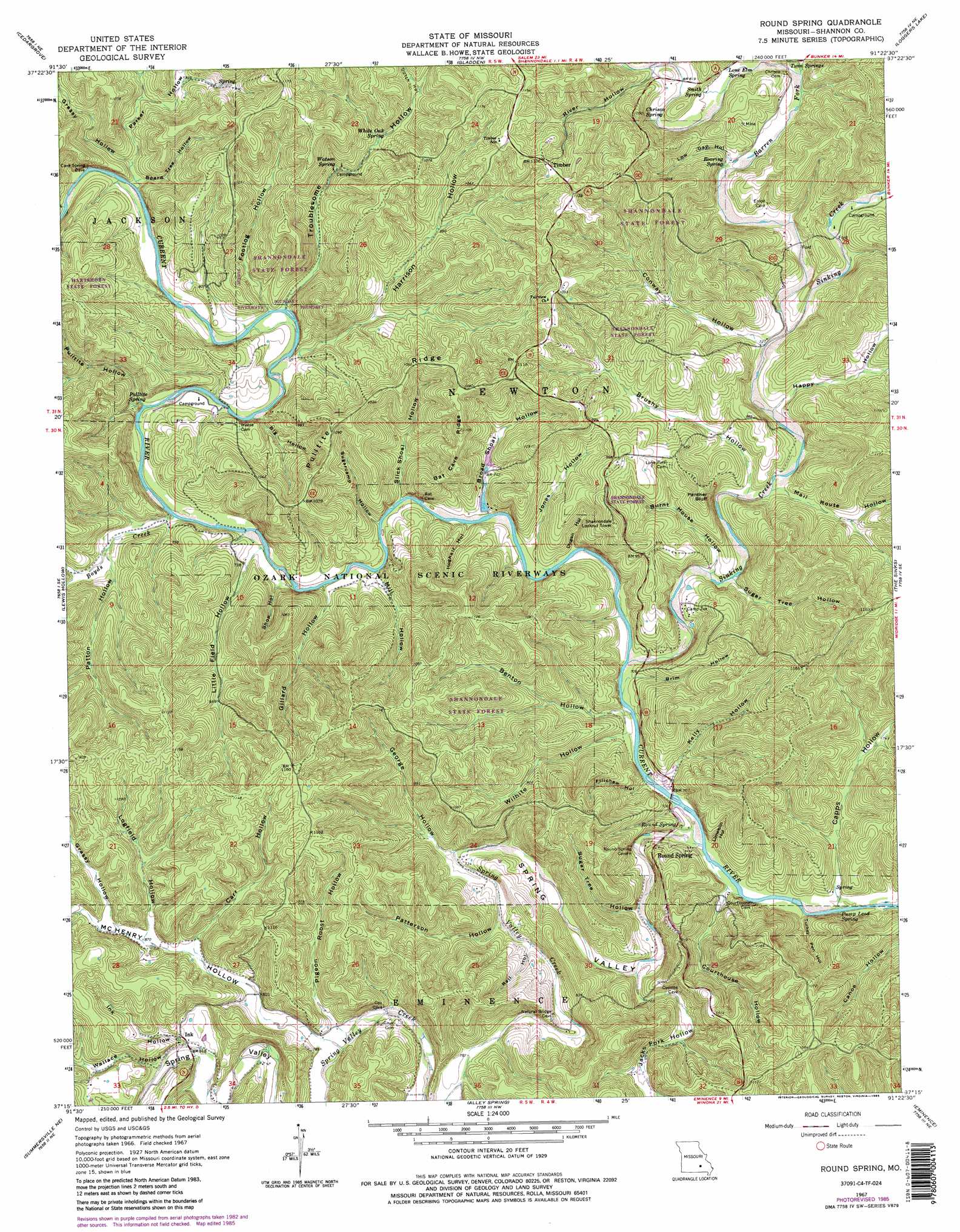
Round Spring Topo Map Missouri
To zoom in, hover over the map of Round Spring
USGS Topo Quad 37091c4 - 1:24,000 scale
| Topo Map Name: | Round Spring |
| USGS Topo Quad ID: | 37091c4 |
| Print Size: | ca. 21 1/4" wide x 27" high |
| Southeast Coordinates: | 37.25° N latitude / 91.375° W longitude |
| Map Center Coordinates: | 37.3125° N latitude / 91.4375° W longitude |
| U.S. State: | MO |
| Filename: | o37091c4.jpg |
| Download Map JPG Image: | Round Spring topo map 1:24,000 scale |
| Map Type: | Topographic |
| Topo Series: | 7.5´ |
| Map Scale: | 1:24,000 |
| Source of Map Images: | United States Geological Survey (USGS) |
| Alternate Map Versions: |
Round Spring MO 1967, updated 1970 Download PDF Buy paper map Round Spring MO 1967, updated 1977 Download PDF Buy paper map Round Spring MO 1967, updated 1985 Download PDF Buy paper map Round Spring MO 1967, updated 1985 Download PDF Buy paper map Round Spring MO 2011 Download PDF Buy paper map Round Spring MO 2015 Download PDF Buy paper map |
1:24,000 Topo Quads surrounding Round Spring
Rhyse |
Darien |
Doss |
Stone Hill |
Greeley |
Montauk |
Cedar Grove |
Gladden |
Loggers Lake |
Bunker |
Hartshorn |
Lewis Hollow |
Round Spring |
The Sinks |
Midridge |
Summersville |
Summersville Ne |
Alley Spring |
Eminence |
Powder Mill Ferry |
Pine Crest |
Jam Up Cave |
Bartlett |
Winona |
Stegall Mountain |
> Back to 37091a1 at 1:100,000 scale
> Back to 37090a1 at 1:250,000 scale
> Back to U.S. Topo Maps home
Round Spring topo map: Gazetteer
Round Spring: Airports
Haven Wood Airport elevation 221m 725′Round Spring: Arches
Round Spring Natural Bridge elevation 208m 682′Round Spring: Channels
Big Solution Hole elevation 226m 741′Round Spring: Cliffs
Panther Bluff elevation 260m 853′Round Spring: Dams
Alton Club Lake Dam elevation 239m 784′Round Spring: Forests
Shannondale State Forest elevation 281m 921′Round Spring: Parks
Round Spring State Park elevation 231m 757′Round Spring State Park (historical) elevation 229m 751′
Round Spring: Populated Places
Ink elevation 254m 833′Round Spring elevation 216m 708′
Timber elevation 336m 1102′
Round Spring: Ridges
Bat Cave Ridge elevation 311m 1020′Pulltite Ridge elevation 314m 1030′
Round Spring: Springs
Cave Spring elevation 267m 875′Chrisco Spring elevation 266m 872′
Fire Hydrant Spring elevation 220m 721′
Lone Elm Spring elevation 242m 793′
Pulltite Spring elevation 242m 793′
Pump Lead Spring elevation 209m 685′
Roaring Spring elevation 238m 780′
Round Spring elevation 208m 682′
Smith Spring elevation 254m 833′
Watson Spring elevation 257m 843′
White Oak Spring elevation 276m 905′
Round Spring: Streams
Barren Fork elevation 220m 721′Boyds Creek elevation 219m 718′
Sinking Creek elevation 209m 685′
Spring Valley Creek elevation 205m 672′
Round Spring: Valleys
Benton Hollow elevation 209m 685′Big Hollow elevation 220m 721′
Board Tree Hollow elevation 229m 751′
Brim Hollow elevation 209m 685′
Broad Shoal Hollow elevation 217m 711′
Brushy Hollow elevation 218m 715′
Burnt House Hollow elevation 213m 698′
Capps Hollow elevation 202m 662′
Carr Hollow elevation 260m 853′
Conway Hollow elevation 224m 734′
Courthouse Hollow elevation 206m 675′
Devils Well Hollow elevation 245m 803′
Dugan Hollow elevation 214m 702′
Dutch Hollow elevation 269m 882′
Fillchew Hollow elevation 209m 685′
Footlog Hollow elevation 224m 734′
George Hollow elevation 220m 721′
Gillard Hollow elevation 215m 705′
Grassy Hollow elevation 271m 889′
Grassy Hollow elevation 234m 767′
Happy Hollow elevation 219m 718′
Harrison Hollow elevation 226m 741′
Hoghair Hollow elevation 215m 705′
Ink Hollow elevation 250m 820′
Jacks Fork Hollow elevation 213m 698′
Jones Hollow elevation 213m 698′
Kelly Hollow elevation 209m 685′
Limekiln Hollow elevation 206m 675′
Little Field Hollow elevation 218m 715′
Logfield Hollow elevation 263m 862′
Low Gap Hollow elevation 238m 780′
Mail Route Hollow elevation 218m 715′
McHenry Hollow elevation 241m 790′
Mill Hollow elevation 215m 705′
Parker Hollow elevation 230m 754′
Patterson Hollow elevation 223m 731′
Patton Hollow elevation 229m 751′
Pigeon Roost Hollow elevation 242m 793′
Pulltite Hollow elevation 220m 721′
Rail Hollow elevation 227m 744′
River Hollow elevation 254m 833′
Shop Hollow elevation 220m 721′
Slick Shoal Hollow elevation 215m 705′
Spring Valley elevation 205m 672′
Sugar Tree Hollow elevation 210m 688′
Sugar Tree Hollow elevation 213m 698′
Sugarcamp Hollow elevation 217m 711′
Troublesome Hollow elevation 225m 738′
Turkey Pen Hollow elevation 202m 662′
Wallace Hollow elevation 253m 830′
Wilhite Hollow elevation 209m 685′
Round Spring digital topo map on disk
Buy this Round Spring topo map showing relief, roads, GPS coordinates and other geographical features, as a high-resolution digital map file on DVD: