Houston Topo Map Missouri
To zoom in, hover over the map of Houston
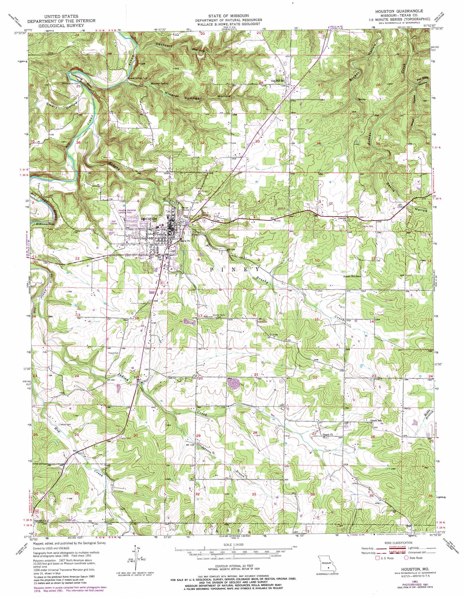
USGS Topo Quad 37091c8 - 1:24,000 scale
| Topo Map Name: | Houston |
| USGS Topo Quad ID: | 37091c8 |
| Print Size: | ca. 21 1/4" wide x 27" high |
| Southeast Coordinates: | 37.25° N latitude / 91.875° W longitude |
| Map Center Coordinates: | 37.3125° N latitude / 91.9375° W longitude |
| U.S. State: | MO |
| Filename: | o37091c8.jpg |
| Download Map JPG Image: | Houston topo map 1:24,000 scale |
| Map Type: | Topographic |
| Topo Series: | 7.5´ |
| Map Scale: | 1:24,000 |
| Source of Map Images: | United States Geological Survey (USGS) |
| Alternate Map Versions: |
Houston MO 1951, updated 1952 Download PDF Buy paper map Houston MO 1951, updated 1956 Download PDF Buy paper map Houston MO 1951, updated 1973 Download PDF Buy paper map Houston MO 1951, updated 1981 Download PDF Buy paper map Houston MO 2012 Download PDF Buy paper map Houston MO 2015 Download PDF Buy paper map |
1:24,000 Topo Quads surrounding Houston
Roby |
Slabtown Spring |
Beulah |
Maples |
Rhyse |
Roubidoux |
Success |
Prescott |
Licking |
Montauk |
Huggins |
Bucyrus |
Houston |
Raymondville |
Hartshorn |
Cabool Nw |
Cabool Ne |
Elk Creek |
Eunice |
Summersville |
Cabool Sw |
Cabool Se |
Willow Springs North |
Clear Springs |
Pine Crest |
> Back to 37091a1 at 1:100,000 scale
> Back to 37090a1 at 1:250,000 scale
> Back to U.S. Topo Maps home
Houston topo map: Gazetteer
Houston: Airports
Houston Memorial Airport elevation 355m 1164′Houston: Bends
Horseshoe Bend elevation 321m 1053′Houston: Dams
Hutcheson Lake Dam elevation 338m 1108′Hutcheson Lake Dam elevation 338m 1108′
Houston: Populated Places
Houston elevation 355m 1164′Mineral Springs City elevation 357m 1171′
Samoa elevation 372m 1220′
Houston: Rapids
McKinney Eddy elevation 304m 997′Houston: Reservoirs
Hutcheson Lake elevation 338m 1108′Houston: Springs
Mineral Spring elevation 310m 1017′Houston: Streams
Brushy Creek elevation 299m 980′Indian Creek elevation 311m 1020′
Johnson Branch elevation 334m 1095′
Houston: Valleys
Cathcart Hollow elevation 297m 974′Devils Hollow elevation 357m 1171′
Emery Hollow elevation 299m 980′
Flat Rock Hollow elevation 335m 1099′
Mineral Springs Hollow elevation 296m 971′
Wood Hollow elevation 338m 1108′
Houston digital topo map on disk
Buy this Houston topo map showing relief, roads, GPS coordinates and other geographical features, as a high-resolution digital map file on DVD: