Cedar Grove Topo Map Missouri
To zoom in, hover over the map of Cedar Grove
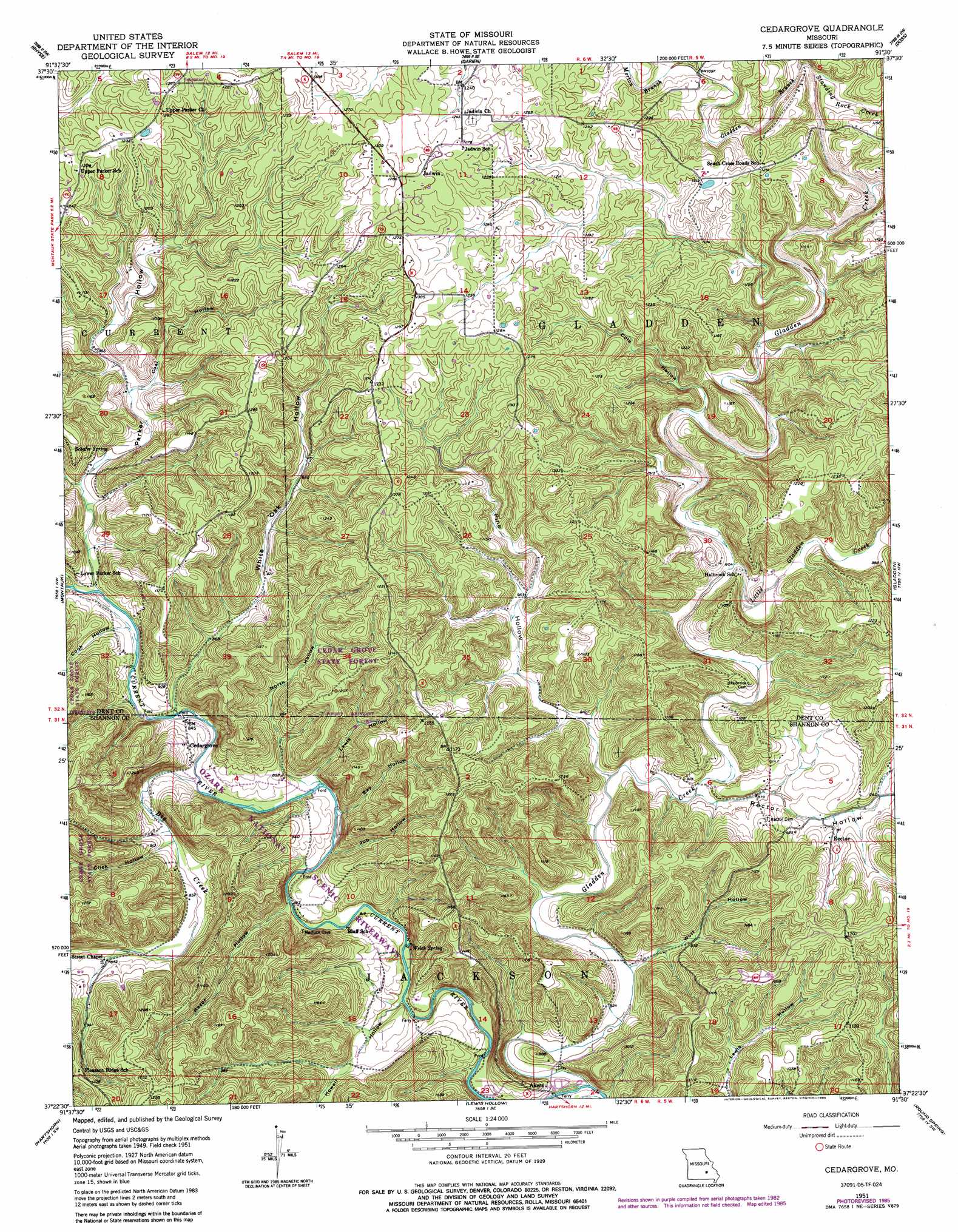
USGS Topo Quad 37091d5 - 1:24,000 scale
| Topo Map Name: | Cedar Grove |
| USGS Topo Quad ID: | 37091d5 |
| Print Size: | ca. 21 1/4" wide x 27" high |
| Southeast Coordinates: | 37.375° N latitude / 91.5° W longitude |
| Map Center Coordinates: | 37.4375° N latitude / 91.5625° W longitude |
| U.S. State: | MO |
| Filename: | o37091d5.jpg |
| Download Map JPG Image: | Cedar Grove topo map 1:24,000 scale |
| Map Type: | Topographic |
| Topo Series: | 7.5´ |
| Map Scale: | 1:24,000 |
| Source of Map Images: | United States Geological Survey (USGS) |
| Alternate Map Versions: |
Cedargrove MO 1951, updated 1952 Download PDF Buy paper map Cedargrove MO 1951, updated 1963 Download PDF Buy paper map Cedargrove MO 1951, updated 1974 Download PDF Buy paper map Cedargrove MO 1951, updated 1980 Download PDF Buy paper map Cedargrove MO 1951, updated 1985 Download PDF Buy paper map Cedargrove MO 2011 Download PDF Buy paper map Cedargrove MO 2015 Download PDF Buy paper map |
1:24,000 Topo Quads surrounding Cedar Grove
Edgar Springs |
Anutt |
Salem |
Short Bend |
Howes Mill Spring |
Maples |
Rhyse |
Darien |
Doss |
Stone Hill |
Licking |
Montauk |
Cedar Grove |
Gladden |
Loggers Lake |
Raymondville |
Hartshorn |
Lewis Hollow |
Round Spring |
The Sinks |
Eunice |
Summersville |
Summersville Ne |
Alley Spring |
Eminence |
> Back to 37091a1 at 1:100,000 scale
> Back to 37090a1 at 1:250,000 scale
> Back to U.S. Topo Maps home
Cedar Grove topo map: Gazetteer
Cedar Grove: Forests
Cedar Grove State Forest elevation 369m 1210′Cedar Grove: Populated Places
Akers elevation 251m 823′Cedargrove elevation 276m 905′
Jadwin elevation 396m 1299′
Rector elevation 288m 944′
Cedar Grove: Springs
Schafer Spring elevation 283m 928′Welch Spring elevation 244m 800′
Cedar Grove: Streams
Big Creek elevation 250m 820′Gladden Branch elevation 324m 1062′
Gladden Creek elevation 233m 764′
Halbrook Branch elevation 336m 1102′
Little Gladden Creek elevation 280m 918′
Morton Branch elevation 337m 1105′
Standing Rock Creek elevation 321m 1053′
Cedar Grove: Valleys
Bay Hollow elevation 244m 800′Brushy Hollow elevation 258m 846′
Click Hollow elevation 256m 839′
Coal Hollow elevation 287m 941′
Cole Hollow elevation 292m 958′
Cook Hollow elevation 257m 843′
Counts Hollow elevation 291m 954′
Howell Hollow elevation 263m 862′
Job Hollow elevation 244m 800′
Lewis Hollow elevation 249m 816′
North Hollow elevation 250m 820′
Parker Hollow elevation 257m 843′
Pine Hollow elevation 258m 846′
Razor Hollow elevation 248m 813′
Rector Hollow elevation 266m 872′
White Oak Hollow elevation 255m 836′
Wolf Hollow elevation 248m 813′
Cedar Grove digital topo map on disk
Buy this Cedar Grove topo map showing relief, roads, GPS coordinates and other geographical features, as a high-resolution digital map file on DVD: