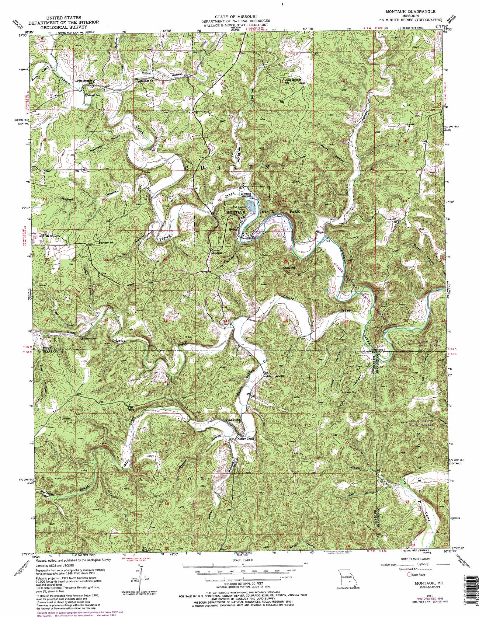
Montauk Topo Map Missouri
To zoom in, hover over the map of Montauk
USGS Topo Quad 37091d6 - 1:24,000 scale
| Topo Map Name: | Montauk |
| USGS Topo Quad ID: | 37091d6 |
| Print Size: | ca. 21 1/4" wide x 27" high |
| Southeast Coordinates: | 37.375° N latitude / 91.625° W longitude |
| Map Center Coordinates: | 37.4375° N latitude / 91.6875° W longitude |
| U.S. State: | MO |
| Filename: | o37091d6.jpg |
| Download Map JPG Image: | Montauk topo map 1:24,000 scale |
| Map Type: | Topographic |
| Topo Series: | 7.5´ |
| Map Scale: | 1:24,000 |
| Source of Map Images: | United States Geological Survey (USGS) |
| Alternate Map Versions: |
Montauk MO 1951, updated 1952 Download PDF Buy paper map Montauk MO 1951, updated 1963 Download PDF Buy paper map Montauk MO 1951, updated 1970 Download PDF Buy paper map Montauk MO 1951, updated 1985 Download PDF Buy paper map Montauk MO 1951, updated 1985 Download PDF Buy paper map Montauk MO 2011 Download PDF Buy paper map Montauk MO 2015 Download PDF Buy paper map |
1:24,000 Topo Quads surrounding Montauk
Flat |
Edgar Springs |
Anutt |
Salem |
Short Bend |
Beulah |
Maples |
Rhyse |
Darien |
Doss |
Prescott |
Licking |
Montauk |
Cedar Grove |
Gladden |
Houston |
Raymondville |
Hartshorn |
Lewis Hollow |
Round Spring |
Elk Creek |
Eunice |
Summersville |
Summersville Ne |
Alley Spring |
> Back to 37091a1 at 1:100,000 scale
> Back to 37090a1 at 1:250,000 scale
> Back to U.S. Topo Maps home
Montauk topo map: Gazetteer
Montauk: Bends
The S Turn elevation 257m 843′Montauk: Channels
Tan Vat Hole elevation 272m 892′Montauk: Parks
Montauk State Park elevation 285m 935′Montauk: Plains
Salem Upland elevation 354m 1161′Montauk: Populated Places
Ashley Creek elevation 293m 961′Montauk elevation 351m 1151′
Montauk: Springs
Montauk Springs elevation 285m 935′Montauk: Streams
Ashley Creek elevation 266m 872′Bean Creek elevation 323m 1059′
Caps Branch elevation 271m 889′
North Ashley Creek elevation 275m 902′
Pigeon Creek elevation 272m 892′
South Ashley Creek elevation 275m 902′
Montauk: Valleys
Alred Hollow elevation 268m 879′Bell Hollow elevation 263m 862′
Cooper Hollow elevation 311m 1020′
Crabtree Hollow elevation 286m 938′
Creek Hollow elevation 296m 971′
Dead Horse Hollow elevation 328m 1076′
Duke Hollow elevation 281m 921′
Falls Hollow elevation 299m 980′
Haley Hollow elevation 323m 1059′
Head Hollow elevation 282m 925′
Hollowell Hollow elevation 308m 1010′
Hoosier Hollow elevation 323m 1059′
Horse Hollow elevation 291m 954′
Inman Hollow elevation 275m 902′
Kell Hollow elevation 264m 866′
Krewson Hollow elevation 263m 862′
Lick Hollow elevation 285m 935′
Long Hollow elevation 316m 1036′
Medley Hollow elevation 302m 990′
Medlock Hollow elevation 323m 1059′
Weaver Hollow elevation 298m 977′
Well Hollow elevation 321m 1053′
White Hollow elevation 323m 1059′
Wolf Hollow elevation 311m 1020′
Woodard Hollow elevation 302m 990′
Montauk digital topo map on disk
Buy this Montauk topo map showing relief, roads, GPS coordinates and other geographical features, as a high-resolution digital map file on DVD: