Viburnum East Topo Map Missouri
To zoom in, hover over the map of Viburnum East
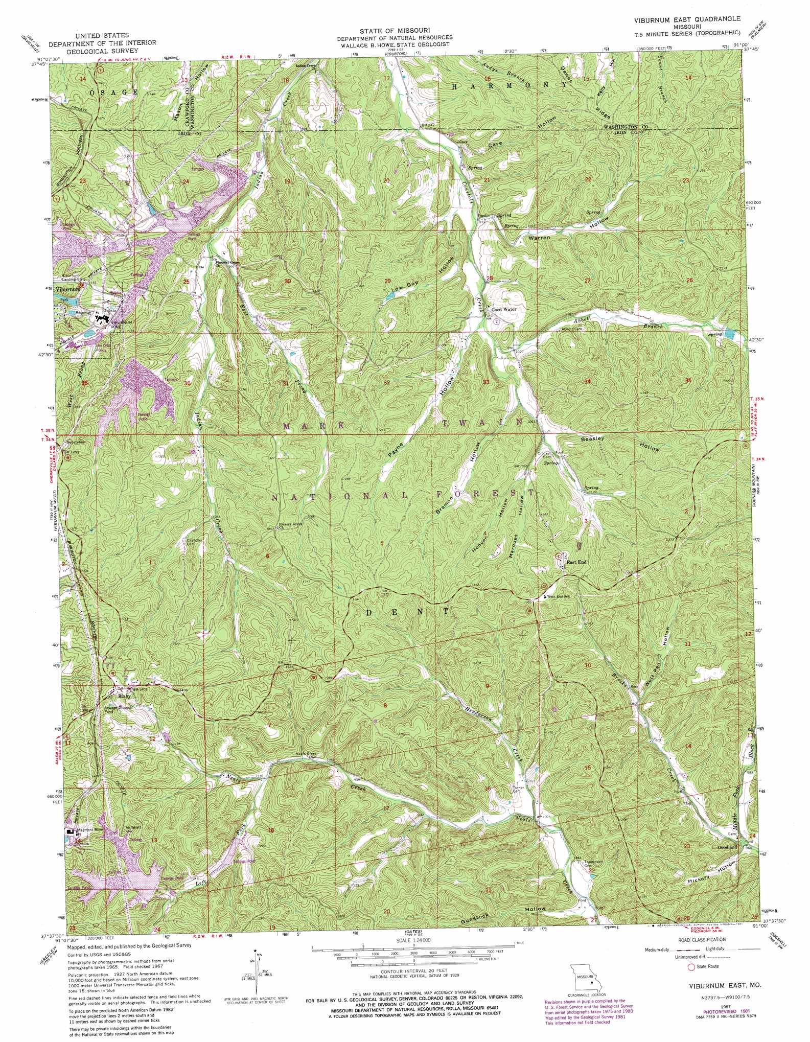
USGS Topo Quad 37091f1 - 1:24,000 scale
| Topo Map Name: | Viburnum East |
| USGS Topo Quad ID: | 37091f1 |
| Print Size: | ca. 21 1/4" wide x 27" high |
| Southeast Coordinates: | 37.625° N latitude / 91° W longitude |
| Map Center Coordinates: | 37.6875° N latitude / 91.0625° W longitude |
| U.S. State: | MO |
| Filename: | o37091f1.jpg |
| Download Map JPG Image: | Viburnum East topo map 1:24,000 scale |
| Map Type: | Topographic |
| Topo Series: | 7.5´ |
| Map Scale: | 1:24,000 |
| Source of Map Images: | United States Geological Survey (USGS) |
| Alternate Map Versions: |
Viburnum East MO 1967, updated 1968 Download PDF Buy paper map Viburnum East MO 1967, updated 1969 Download PDF Buy paper map Viburnum East MO 1967, updated 1975 Download PDF Buy paper map Viburnum East MO 1967, updated 1981 Download PDF Buy paper map Viburnum East MO 1967, updated 1981 Download PDF Buy paper map Viburnum East MO 1999, updated 2002 Download PDF Buy paper map Viburnum East MO 2011 Download PDF Buy paper map Viburnum East MO 2015 Download PDF Buy paper map |
| FStopo: | US Forest Service topo Viburnum East is available: Download FStopo PDF Download FStopo TIF |
1:24,000 Topo Quads surrounding Viburnum East
Steelville |
Huzzah |
Berryman |
Shirley |
Potosi |
Cherryville |
Davisville |
Courtois |
Palmer |
Belgrade |
Howes Mill Spring |
Viburnum West |
Viburnum East |
Johnson Mountain |
Banner |
Stone Hill |
Greeley |
Oates |
Edgehill |
Johnson Shut-Ins |
Loggers Lake |
Bunker |
Corridon |
Centerville |
Lesterville |
> Back to 37091e1 at 1:100,000 scale
> Back to 37090a1 at 1:250,000 scale
> Back to U.S. Topo Maps home
Viburnum East topo map: Gazetteer
Viburnum East: Dams
Clearwater Lake Dam elevation 349m 1145′County Road Dam elevation 315m 1033′
Magmont Mine Tailings Dam elevation 380m 1246′
Mononame 812 Dam elevation 368m 1207′
Mononame 830 Dam elevation 369m 1210′
New Viburnum Tailings Dam elevation 350m 1148′
Number 29 Mine Ore Haul Road North Dam elevation 332m 1089′
Number 29 Mine Ore Haul Road South Dam elevation 371m 1217′
Old Viburnum Tailings Dam elevation 296m 971′
Railroad Embankment Dam elevation 335m 1099′
Viburnum Tailings Dam Number 5 elevation 354m 1161′
Viburnum Tailings Number 2 Dam elevation 313m 1026′
Viburnum East: Forests
Salem - Potosi Ranger Districts elevation 402m 1318′Viburnum East: Mines
Burt Iron Bank elevation 371m 1217′Cove Iron Bank elevation 316m 1036′
Magmont Mine elevation 428m 1404′
Rogers Iron Bank elevation 391m 1282′
Saint Joe Shaft Thirty five elevation 406m 1332′
Viburnum Mine elevation 337m 1105′
Viburnum East: Populated Places
Bixby elevation 428m 1404′East End elevation 404m 1325′
Good Water elevation 311m 1020′
Goodland elevation 290m 951′
Viburnum East: Reservoirs
Intermediate Viburnum Tailings Pond elevation 313m 1026′Magmont Main Tailings Lake elevation 380m 1246′
New Viburnum Tailings Pond elevation 350m 1148′
Old Viburnum Tailings Pond elevation 296m 971′
Queen Mary Pond elevation 332m 1089′
Viburnum City Park Lake elevation 371m 1217′
Viburnum Tailings Disposal A Reservoir elevation 315m 1033′
Viburnum East: Streams
Abbott Branch elevation 310m 1017′Brooks Creek elevation 289m 948′
East Prong Indian Creek elevation 295m 967′
Henderson Creek elevation 304m 997′
Left Fork Neals Creek elevation 339m 1112′
Walnut Branch elevation 301m 987′
West Prong Indian Creek elevation 289m 948′
Viburnum East: Valleys
Beasley Hollow elevation 326m 1069′Bramon Hollow elevation 317m 1040′
Cave Hollow elevation 304m 997′
Gunstock Hollow elevation 296m 971′
Hickory Hollow elevation 293m 961′
Hoover Hollow elevation 335m 1099′
Low Gap Hollow elevation 294m 964′
Marques Hollow elevation 341m 1118′
Payne Hollow elevation 307m 1007′
Warren Hollow elevation 301m 987′
Wolf Pen Hollow elevation 326m 1069′
Viburnum East digital topo map on disk
Buy this Viburnum East topo map showing relief, roads, GPS coordinates and other geographical features, as a high-resolution digital map file on DVD: