Viburnum West Topo Map Missouri
To zoom in, hover over the map of Viburnum West
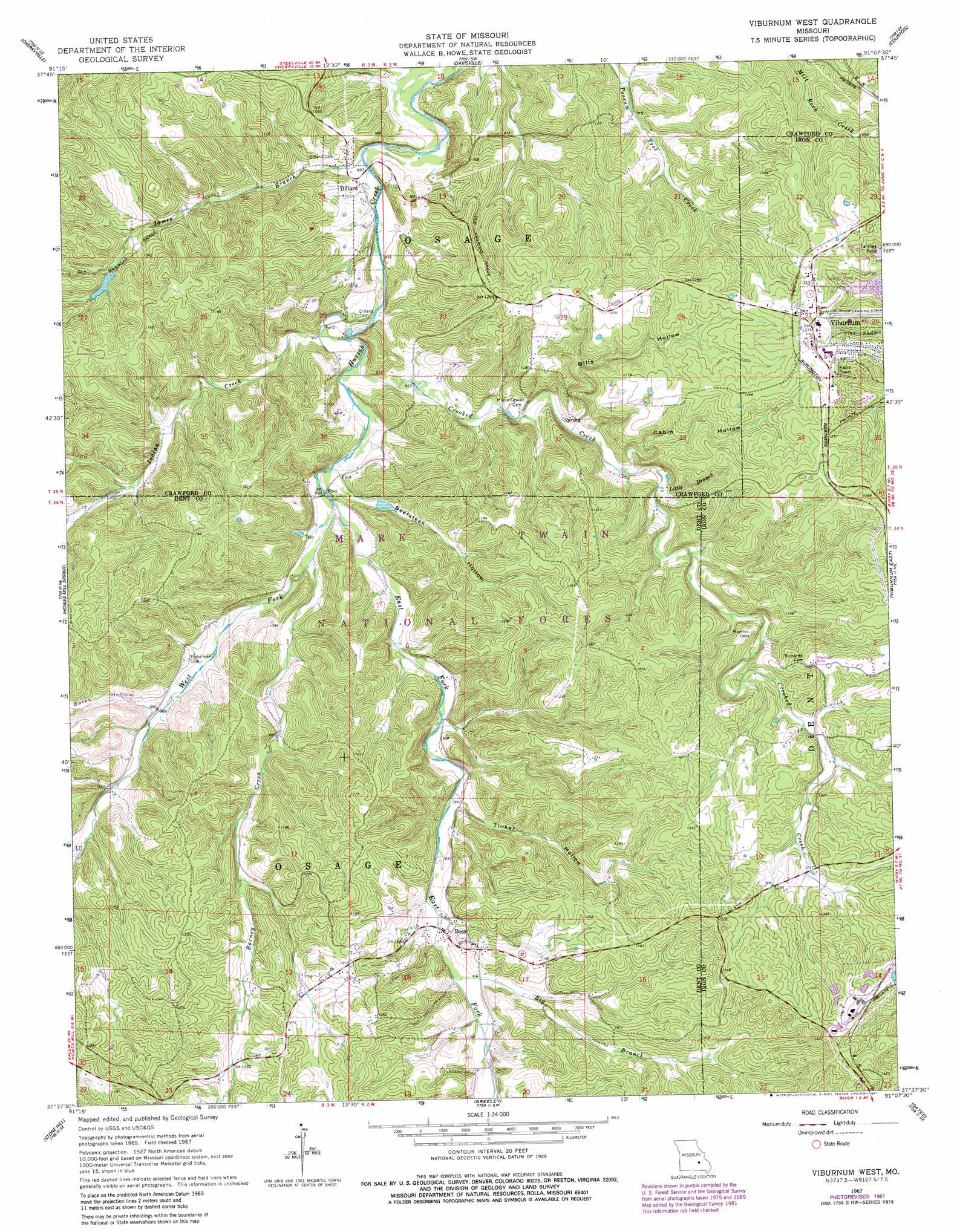
USGS Topo Quad 37091f2 - 1:24,000 scale
| Topo Map Name: | Viburnum West |
| USGS Topo Quad ID: | 37091f2 |
| Print Size: | ca. 21 1/4" wide x 27" high |
| Southeast Coordinates: | 37.625° N latitude / 91.125° W longitude |
| Map Center Coordinates: | 37.6875° N latitude / 91.1875° W longitude |
| U.S. State: | MO |
| Filename: | o37091f2.jpg |
| Download Map JPG Image: | Viburnum West topo map 1:24,000 scale |
| Map Type: | Topographic |
| Topo Series: | 7.5´ |
| Map Scale: | 1:24,000 |
| Source of Map Images: | United States Geological Survey (USGS) |
| Alternate Map Versions: |
Viburnum West MO 1967, updated 1968 Download PDF Buy paper map Viburnum West MO 1967, updated 1969 Download PDF Buy paper map Viburnum West MO 1967, updated 1978 Download PDF Buy paper map Viburnum West MO 1967, updated 1981 Download PDF Buy paper map Viburnum West MO 1967, updated 1981 Download PDF Buy paper map Viburnum West MO 1999, updated 2002 Download PDF Buy paper map Viburnum West MO 2011 Download PDF Buy paper map Viburnum West MO 2015 Download PDF Buy paper map |
| FStopo: | US Forest Service topo Viburnum West is available: Download FStopo PDF Download FStopo TIF |
1:24,000 Topo Quads surrounding Viburnum West
Indian Springs |
Steelville |
Huzzah |
Berryman |
Shirley |
Cook Station |
Cherryville |
Davisville |
Courtois |
Palmer |
Short Bend |
Howes Mill Spring |
Viburnum West |
Viburnum East |
Johnson Mountain |
Doss |
Stone Hill |
Greeley |
Oates |
Edgehill |
Gladden |
Loggers Lake |
Bunker |
Corridon |
Centerville |
> Back to 37091e1 at 1:100,000 scale
> Back to 37090a1 at 1:250,000 scale
> Back to U.S. Topo Maps home
Viburnum West topo map: Gazetteer
Viburnum West: Airports
Viburnum Airport elevation 378m 1240′Viburnum West: Dams
Amax Impoundment A Dam elevation 408m 1338′Mononame 352 Dam elevation 318m 1043′
Mononame 41 Dam elevation 425m 1394′
Mononame 807 Dam elevation 413m 1354′
Mononame 808 Dam elevation 411m 1348′
Viburnum West: Lakes
Lost Lake elevation 317m 1040′Viburnum West: Mines
Reuben Smith Iron Bank elevation 321m 1053′Viburnum West: Parks
Dillard Mill State Historic Site elevation 276m 905′Viburnum West: Populated Places
Boss elevation 342m 1122′Dillard elevation 272m 892′
Red Point elevation 400m 1312′
Viburnum elevation 387m 1269′
Viburnum West: Streams
Barney Creek elevation 286m 938′Big Branch elevation 311m 1020′
Crooked Creek elevation 279m 915′
East Fork Huzzah Creek elevation 282m 925′
Indian Creek elevation 274m 898′
James Branch elevation 270m 885′
Little Branch elevation 308m 1010′
West Fork Huzzah Creek elevation 282m 925′
Viburnum West: Summits
Dillard Hill elevation 350m 1148′Viburnum West: Valleys
Bates Hollow elevation 299m 980′Beefsteak Hollow elevation 281m 921′
Bills Hollow elevation 300m 984′
Cabin Hollow elevation 304m 997′
Chandler Hollow elevation 303m 994′
Powell Hollow elevation 310m 1017′
Rooney Hollow elevation 305m 1000′
Tinker Hollow elevation 303m 994′
Todd Hollow elevation 303m 994′
Viburnum West digital topo map on disk
Buy this Viburnum West topo map showing relief, roads, GPS coordinates and other geographical features, as a high-resolution digital map file on DVD: