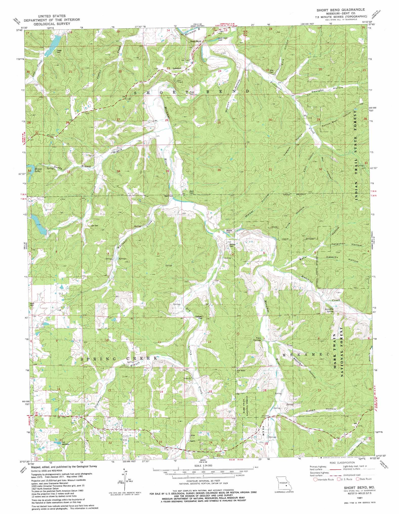
Short Bend Topo Map Missouri
To zoom in, hover over the map of Short Bend
USGS Topo Quad 37091f4 - 1:24,000 scale
| Topo Map Name: | Short Bend |
| USGS Topo Quad ID: | 37091f4 |
| Print Size: | ca. 21 1/4" wide x 27" high |
| Southeast Coordinates: | 37.625° N latitude / 91.375° W longitude |
| Map Center Coordinates: | 37.6875° N latitude / 91.4375° W longitude |
| U.S. State: | MO |
| Filename: | o37091f4.jpg |
| Download Map JPG Image: | Short Bend topo map 1:24,000 scale |
| Map Type: | Topographic |
| Topo Series: | 7.5´ |
| Map Scale: | 1:24,000 |
| Source of Map Images: | United States Geological Survey (USGS) |
| Alternate Map Versions: |
Short Bend MO 1981, updated 1981 Download PDF Buy paper map Short Bend MO 2011 Download PDF Buy paper map Short Bend MO 2015 Download PDF Buy paper map |
| FStopo: | US Forest Service topo Short Bend is available: Download FStopo PDF Download FStopo TIF |
1:24,000 Topo Quads surrounding Short Bend
Dillon |
Maramec Spring |
Indian Springs |
Steelville |
Huzzah |
Lecoma |
Seaton |
Cook Station |
Cherryville |
Davisville |
Anutt |
Salem |
Short Bend |
Howes Mill Spring |
Viburnum West |
Rhyse |
Darien |
Doss |
Stone Hill |
Greeley |
Montauk |
Cedar Grove |
Gladden |
Loggers Lake |
Bunker |
> Back to 37091e1 at 1:100,000 scale
> Back to 37090a1 at 1:250,000 scale
> Back to U.S. Topo Maps home
Short Bend topo map: Gazetteer
Short Bend: Dams
Honey Lake Dam elevation 349m 1145′Masters Dam elevation 318m 1043′
Mitchell Dam elevation 334m 1095′
Warner Dam elevation 336m 1102′
Short Bend: Populated Places
Dent Ford elevation 299m 980′Mounce elevation 346m 1135′
Short Bend elevation 306m 1003′
Short Bend: Reservoirs
Honey Lake elevation 345m 1131′Masters Lake elevation 318m 1043′
Mooney Lake elevation 334m 1095′
Short Bend: Springs
Gamblin Spring elevation 317m 1040′Twin Springs elevation 316m 1036′
Short Bend: Streams
Dowdy Branch elevation 297m 974′Dry Valley Creek elevation 303m 994′
Fishwater Creek elevation 286m 938′
Hutchins Creek elevation 306m 1003′
Nelson Branch elevation 308m 1010′
Simmons Branch elevation 320m 1049′
Whitaker Creek elevation 300m 984′
Short Bend: Valleys
Baker Hollow elevation 308m 1010′Beasley Hollow elevation 316m 1036′
Capps Hollow elevation 322m 1056′
Cassidy Hollow elevation 319m 1046′
Deerpen Hollow elevation 306m 1003′
Ellis Hollow elevation 299m 980′
England Hollow elevation 305m 1000′
Ferguson Hollow elevation 338m 1108′
Gambling Hollow elevation 322m 1056′
Kelly Hollow elevation 312m 1023′
Pine Hollow elevation 307m 1007′
Rollins Bluff Hollow elevation 305m 1000′
Rollins Bluff Hollow elevation 324m 1062′
Walker Hollow elevation 313m 1026′
Watson Hollow elevation 296m 971′
Wet Hollow elevation 312m 1023′
Short Bend digital topo map on disk
Buy this Short Bend topo map showing relief, roads, GPS coordinates and other geographical features, as a high-resolution digital map file on DVD: