Edgar Springs Topo Map Missouri
To zoom in, hover over the map of Edgar Springs
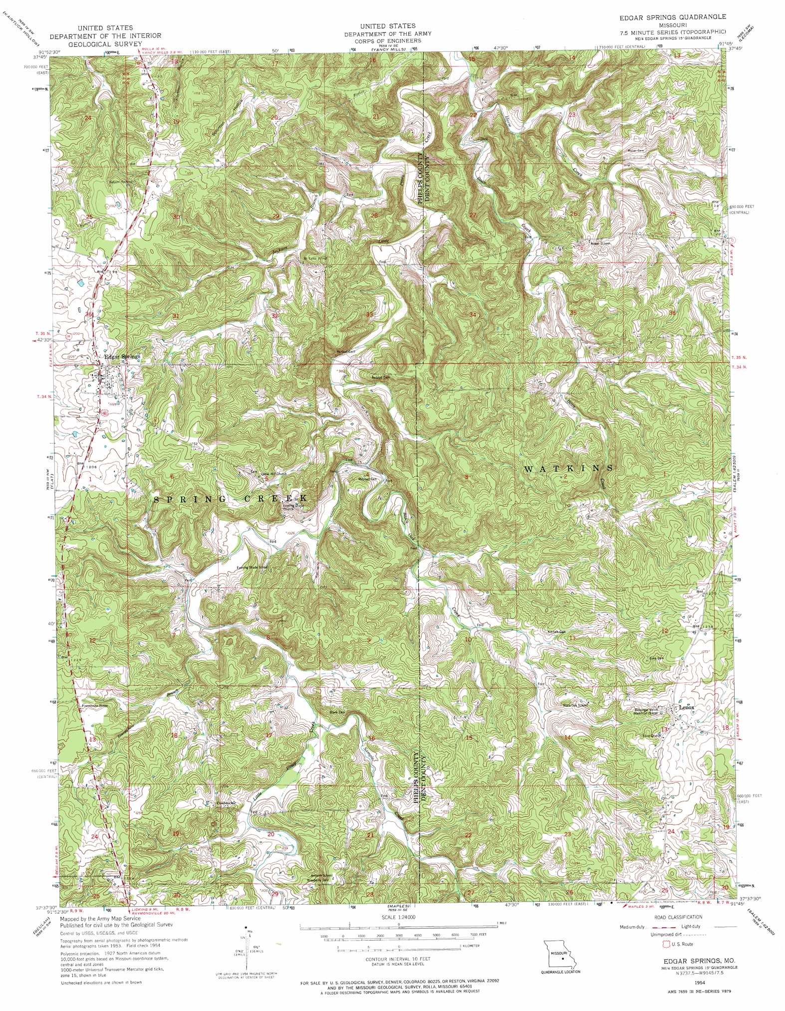
USGS Topo Quad 37091f7 - 1:24,000 scale
| Topo Map Name: | Edgar Springs |
| USGS Topo Quad ID: | 37091f7 |
| Print Size: | ca. 21 1/4" wide x 27" high |
| Southeast Coordinates: | 37.625° N latitude / 91.75° W longitude |
| Map Center Coordinates: | 37.6875° N latitude / 91.8125° W longitude |
| U.S. State: | MO |
| Filename: | o37091f7.jpg |
| Download Map JPG Image: | Edgar Springs topo map 1:24,000 scale |
| Map Type: | Topographic |
| Topo Series: | 7.5´ |
| Map Scale: | 1:24,000 |
| Source of Map Images: | United States Geological Survey (USGS) |
| Alternate Map Versions: |
Edgar Springs MO 1954, updated 1959 Download PDF Buy paper map Edgar Springs MO 1954, updated 1974 Download PDF Buy paper map Edgar Springs MO 2012 Download PDF Buy paper map Edgar Springs MO 2015 Download PDF Buy paper map |
| FStopo: | US Forest Service topo Edgar Springs is available: Download FStopo PDF Download FStopo TIF |
1:24,000 Topo Quads surrounding Edgar Springs
Dixon |
Newburg |
Rolla |
Dillon |
Maramec Spring |
Devils Elbow |
Kaintuck Hollow |
Yancy Mills |
Lecoma |
Seaton |
Big Piney |
Flat |
Edgar Springs |
Anutt |
Salem |
Slabtown Spring |
Beulah |
Maples |
Rhyse |
Darien |
Success |
Prescott |
Licking |
Montauk |
Cedar Grove |
> Back to 37091e1 at 1:100,000 scale
> Back to 37090a1 at 1:250,000 scale
> Back to U.S. Topo Maps home
Edgar Springs topo map: Gazetteer
Edgar Springs: Dams
Tealwood Dam elevation 350m 1148′Edgar Springs: Parks
Richard F Clement Memorial State Forest and Wildlife Area elevation 336m 1102′Edgar Springs: Populated Places
Craddock elevation 373m 1223′Edgar Springs elevation 368m 1207′
Lenox elevation 390m 1279′
North Lenox elevation 387m 1269′
Edgar Springs: Reservoirs
Lake Tealwood elevation 350m 1148′Edgar Springs: Springs
Edgar Spring elevation 348m 1141′Edgar Springs: Streams
Black Oak Creek elevation 307m 1007′Everywhere Branch elevation 320m 1049′
Horse Creek elevation 274m 898′
Jackson Branch elevation 280m 918′
Sample Creek elevation 328m 1076′
Edgar Springs digital topo map on disk
Buy this Edgar Springs topo map showing relief, roads, GPS coordinates and other geographical features, as a high-resolution digital map file on DVD: