Yancy Mills Topo Map Missouri
To zoom in, hover over the map of Yancy Mills
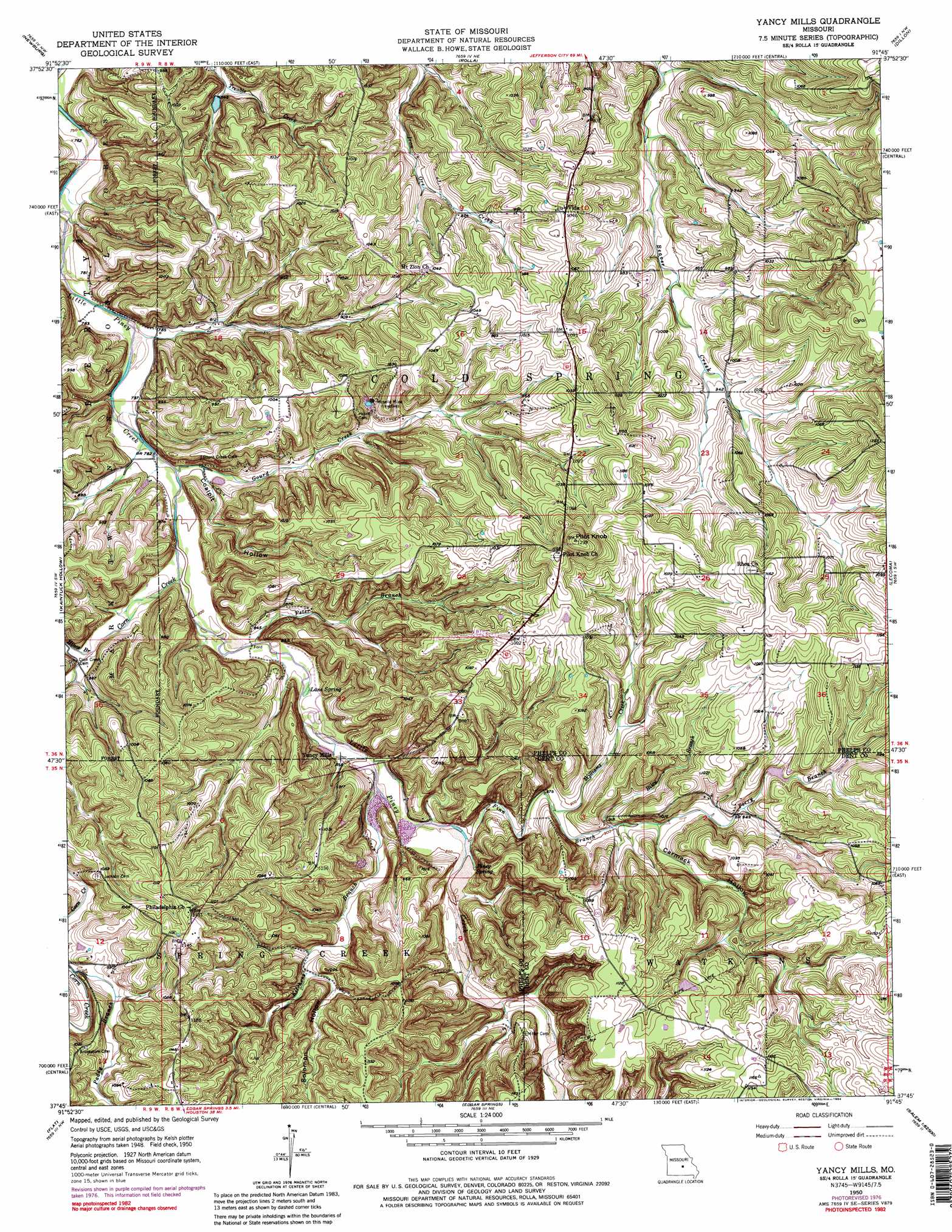
USGS Topo Quad 37091g7 - 1:24,000 scale
| Topo Map Name: | Yancy Mills |
| USGS Topo Quad ID: | 37091g7 |
| Print Size: | ca. 21 1/4" wide x 27" high |
| Southeast Coordinates: | 37.75° N latitude / 91.75° W longitude |
| Map Center Coordinates: | 37.8125° N latitude / 91.8125° W longitude |
| U.S. State: | MO |
| Filename: | o37091g7.jpg |
| Download Map JPG Image: | Yancy Mills topo map 1:24,000 scale |
| Map Type: | Topographic |
| Topo Series: | 7.5´ |
| Map Scale: | 1:24,000 |
| Source of Map Images: | United States Geological Survey (USGS) |
| Alternate Map Versions: |
Yancy Mills MO 1950, updated 1960 Download PDF Buy paper map Yancy Mills MO 1950, updated 1973 Download PDF Buy paper map Yancy Mills MO 1950, updated 1975 Download PDF Buy paper map Yancy Mills MO 1950, updated 1977 Download PDF Buy paper map Yancy Mills MO 1950, updated 1984 Download PDF Buy paper map Yancy Mills MO 1951 Download PDF Buy paper map Yancy Mills MO 2004, updated 2006 Download PDF Buy paper map Yancy Mills MO 2011 Download PDF Buy paper map Yancy Mills MO 2015 Download PDF Buy paper map |
| FStopo: | US Forest Service topo Yancy Mills is available: Download FStopo PDF Download FStopo TIF |
1:24,000 Topo Quads surrounding Yancy Mills
Big Bend |
Nagogami Lodge |
Vichy |
Safe |
Rosati |
Dixon |
Newburg |
Rolla |
Dillon |
Maramec Spring |
Devils Elbow |
Kaintuck Hollow |
Yancy Mills |
Lecoma |
Seaton |
Big Piney |
Flat |
Edgar Springs |
Anutt |
Salem |
Slabtown Spring |
Beulah |
Maples |
Rhyse |
Darien |
> Back to 37091e1 at 1:100,000 scale
> Back to 37090a1 at 1:250,000 scale
> Back to U.S. Topo Maps home
Yancy Mills topo map: Gazetteer
Yancy Mills: Dams
Allison and Haas Lake Dam elevation 309m 1013′Teeters Lake Dam elevation 329m 1079′
Yancy Mills: Mines
Moselle Mine elevation 281m 921′Yancy Mills: Populated Places
Vida elevation 315m 1033′Yancy Mills elevation 257m 843′
Yancy Mills: Post Offices
Yancy Mills Post Office elevation 327m 1072′Yancy Mills Post Office (historical) elevation 332m 1089′
Yancy Mills: Springs
Lane Spring elevation 249m 816′Piney Spring elevation 260m 853′
Yancy Spring elevation 253m 830′
Yancy Mills: Streams
Bean Creek elevation 281m 921′Corn Creek elevation 247m 810′
Finn Branch elevation 257m 843′
Gourd Creek elevation 240m 787′
Hines Branch elevation 251m 823′
Kitchens Branch elevation 253m 830′
Paddy Branch elevation 289m 948′
Perry Branch elevation 276m 905′
Peter Branch elevation 247m 810′
Riley Branch elevation 273m 895′
Williams Creek elevation 274m 898′
Yancy Mills: Summits
Pilot Knob elevation 372m 1220′Yancy Mills: Trails
Blossom Rock Trail elevation 275m 902′Cedar Bluff Trail elevation 249m 816′
Yancy Mills: Valleys
Carmack Hollow elevation 276m 905′Coalpit Hollow elevation 247m 810′
Solomon Hollow elevation 282m 925′
Yancy Mills digital topo map on disk
Buy this Yancy Mills topo map showing relief, roads, GPS coordinates and other geographical features, as a high-resolution digital map file on DVD: