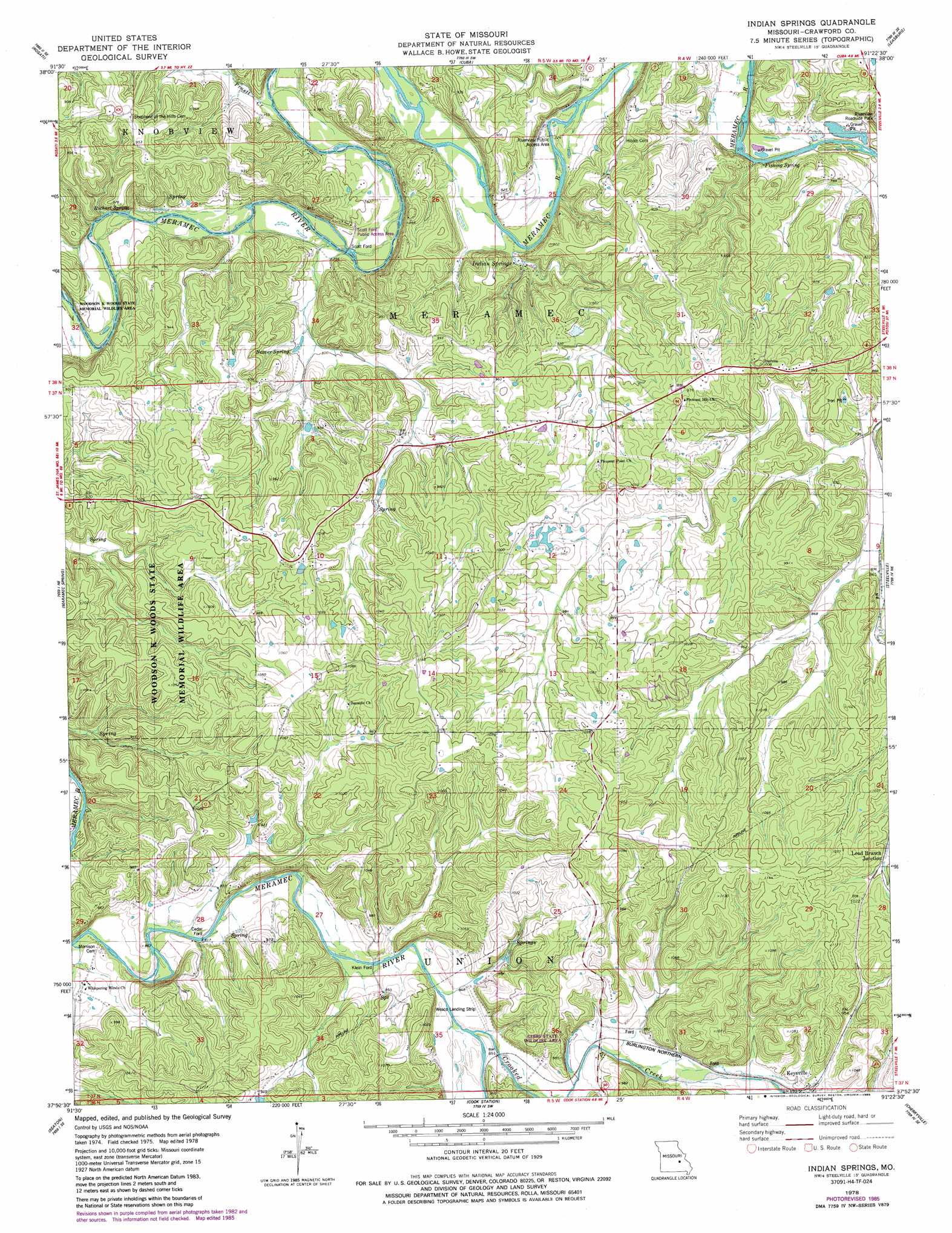
Indian Springs Topo Map Missouri
To zoom in, hover over the map of Indian Springs
USGS Topo Quad 37091h4 - 1:24,000 scale
| Topo Map Name: | Indian Springs |
| USGS Topo Quad ID: | 37091h4 |
| Print Size: | ca. 21 1/4" wide x 27" high |
| Southeast Coordinates: | 37.875° N latitude / 91.375° W longitude |
| Map Center Coordinates: | 37.9375° N latitude / 91.4375° W longitude |
| U.S. State: | MO |
| Filename: | o37091h4.jpg |
| Download Map JPG Image: | Indian Springs topo map 1:24,000 scale |
| Map Type: | Topographic |
| Topo Series: | 7.5´ |
| Map Scale: | 1:24,000 |
| Source of Map Images: | United States Geological Survey (USGS) |
| Alternate Map Versions: |
Indian Springs MO 1978, updated 1979 Download PDF Buy paper map Indian Springs MO 1978, updated 1985 Download PDF Buy paper map Indian Springs MO 2011 Download PDF Buy paper map Indian Springs MO 2015 Download PDF Buy paper map |
1:24,000 Topo Quads surrounding Indian Springs
High Gate |
Redbird |
Oak Hill |
Argo |
Sullivan |
Safe |
Rosati |
Cuba |
Leasburg |
Onondaga Cave |
Dillon |
Maramec Spring |
Indian Springs |
Steelville |
Huzzah |
Lecoma |
Seaton |
Cook Station |
Cherryville |
Davisville |
Anutt |
Salem |
Short Bend |
Howes Mill Spring |
Viburnum West |
> Back to 37091e1 at 1:100,000 scale
> Back to 37090a1 at 1:250,000 scale
> Back to U.S. Topo Maps home
Indian Springs topo map: Gazetteer
Indian Springs: Dams
Holifield Lake Dam elevation 288m 944′J Bristow Lake Dam elevation 242m 793′
Lake Vera Dam elevation 276m 905′
Number 860 Dam elevation 274m 898′
Seidl Lake Dam elevation 292m 958′
Smith Lake Dam elevation 272m 892′
Indian Springs: Mines
Buffum Iron Mine elevation 320m 1049′Clark and Halbert Iron Mine elevation 271m 889′
Hart Iron Mine elevation 312m 1023′
Lea and Marsh Iron Bank elevation 261m 856′
Marsh Iron Mine elevation 259m 849′
N.G. Clark and Companys Iron Bank elevation 276m 905′
Seay and Marsh Iron Mine elevation 261m 856′
Seay Iron Mine elevation 251m 823′
Steelville Iron Mine elevation 256m 839′
Steelville Number One Iron Bank elevation 252m 826′
Steelville Number two Iron Bank elevation 247m 810′
Indian Springs: Parks
Gibbs State Wildlife Area elevation 259m 849′Riverview Roadside Park elevation 244m 800′
Woodson K Woods State Memorial Wildlife Area elevation 286m 938′
Indian Springs: Populated Places
Cedar Ford elevation 249m 816′Keysville elevation 273m 895′
Klein Ford elevation 251m 823′
Lead Branch Junction elevation 299m 980′
Scott Ford elevation 225m 738′
Thousand Oaks elevation 247m 810′
Indian Springs: Reservoirs
Holifield Lake elevation 288m 944′J Bristow Lake elevation 242m 793′
Lake Vera elevation 276m 905′
Seidl Lake elevation 292m 958′
Smith Lake elevation 272m 892′
Indian Springs: Springs
Beaver Spring elevation 242m 793′Fishing Spring elevation 219m 718′
Indian Springs elevation 222m 728′
Richart Spring elevation 232m 761′
Indian Springs: Streams
Crooked Creek elevation 254m 833′Jones Branch elevation 267m 875′
Pruett Creek elevation 227m 744′
Pruett Creek elevation 226m 741′
Yadkin Creek elevation 243m 797′
Indian Springs digital topo map on disk
Buy this Indian Springs topo map showing relief, roads, GPS coordinates and other geographical features, as a high-resolution digital map file on DVD: