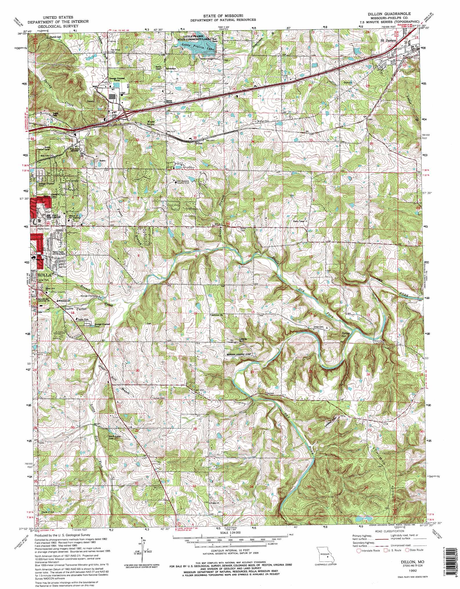
Dillon Topo Map Missouri
To zoom in, hover over the map of Dillon
USGS Topo Quad 37091h6 - 1:24,000 scale
| Topo Map Name: | Dillon |
| USGS Topo Quad ID: | 37091h6 |
| Print Size: | ca. 21 1/4" wide x 27" high |
| Southeast Coordinates: | 37.875° N latitude / 91.625° W longitude |
| Map Center Coordinates: | 37.9375° N latitude / 91.6875° W longitude |
| U.S. State: | MO |
| Filename: | o37091h6.jpg |
| Download Map JPG Image: | Dillon topo map 1:24,000 scale |
| Map Type: | Topographic |
| Topo Series: | 7.5´ |
| Map Scale: | 1:24,000 |
| Source of Map Images: | United States Geological Survey (USGS) |
| Alternate Map Versions: |
Dillon MO 1963, updated 1964 Download PDF Buy paper map Dillon MO 1963, updated 1973 Download PDF Buy paper map Dillon MO 1963, updated 1977 Download PDF Buy paper map Dillon MO 1980, updated 1981 Download PDF Buy paper map Dillon MO 1985, updated 1985 Download PDF Buy paper map Dillon MO 1992, updated 1995 Download PDF Buy paper map Dillon MO 2012 Download PDF Buy paper map Dillon MO 2015 Download PDF Buy paper map |
1:24,000 Topo Quads surrounding Dillon
Vienna |
Paydown |
High Gate |
Redbird |
Oak Hill |
Nagogami Lodge |
Vichy |
Safe |
Rosati |
Cuba |
Newburg |
Rolla |
Dillon |
Maramec Spring |
Indian Springs |
Kaintuck Hollow |
Yancy Mills |
Lecoma |
Seaton |
Cook Station |
Flat |
Edgar Springs |
Anutt |
Salem |
Short Bend |
> Back to 37091e1 at 1:100,000 scale
> Back to 37090a1 at 1:250,000 scale
> Back to U.S. Topo Maps home
Dillon topo map: Gazetteer
Dillon: Airports
Morgan Airport elevation 287m 941′US Airport (historical) elevation 362m 1187′
Dillon: Cliffs
Panther Bluff elevation 294m 964′Dillon: Dams
Little Prairie Dam elevation 310m 1017′Scotts Pond Dam elevation 358m 1174′
Wheelgate Lake Dam elevation 317m 1040′
Dillon: Parks
Hart Park elevation 341m 1118′Little Prairie Community Lake elevation 312m 1023′
Dillon: Populated Places
Dean Ford elevation 262m 859′Dillon elevation 335m 1099′
Dillon: Reservoirs
Little Prairie Lake elevation 303m 994′Scotts Pond elevation 358m 1174′
Wheelgate Lake elevation 317m 1040′
Dillon: Springs
Woods Spring elevation 341m 1118′Dillon: Streams
Dailey Branch elevation 270m 885′Deible Branch elevation 297m 974′
Franz Branch elevation 277m 908′
Green Acre Branch elevation 287m 941′
Little Dry Fork elevation 261m 856′
Dillon digital topo map on disk
Buy this Dillon topo map showing relief, roads, GPS coordinates and other geographical features, as a high-resolution digital map file on DVD: