Mountain Grove North Topo Map Missouri
To zoom in, hover over the map of Mountain Grove North
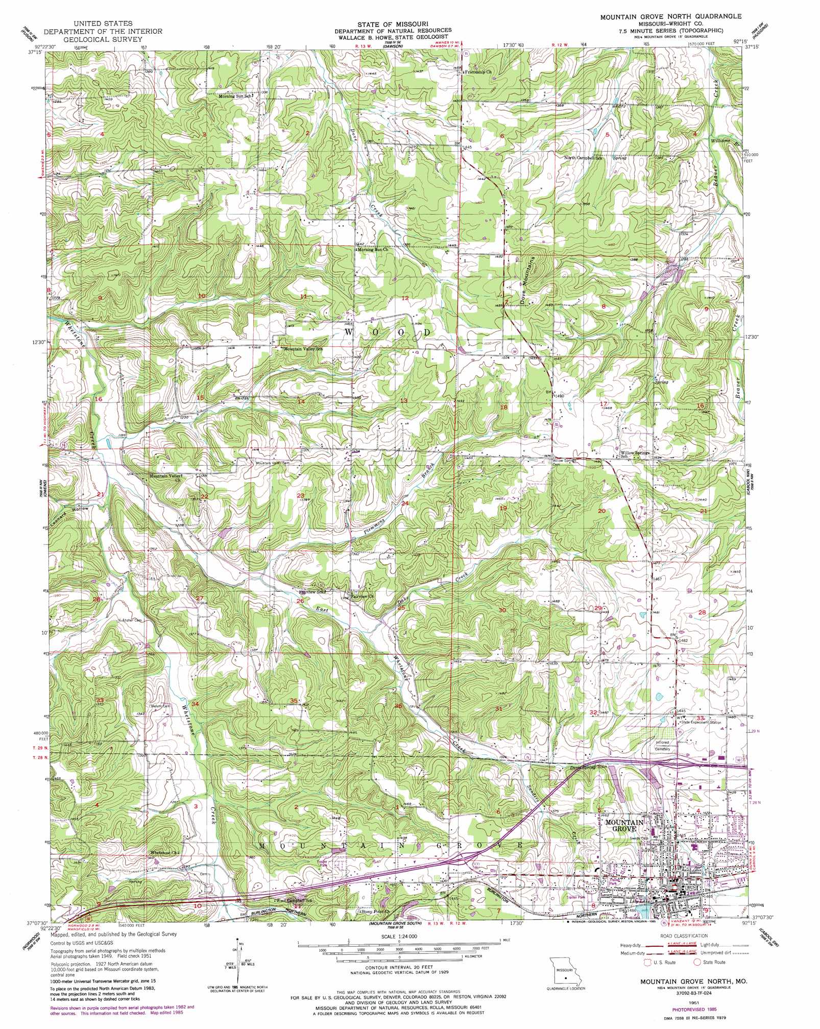
USGS Topo Quad 37092b3 - 1:24,000 scale
| Topo Map Name: | Mountain Grove North |
| USGS Topo Quad ID: | 37092b3 |
| Print Size: | ca. 21 1/4" wide x 27" high |
| Southeast Coordinates: | 37.125° N latitude / 92.25° W longitude |
| Map Center Coordinates: | 37.1875° N latitude / 92.3125° W longitude |
| U.S. State: | MO |
| Filename: | o37092b3.jpg |
| Download Map JPG Image: | Mountain Grove North topo map 1:24,000 scale |
| Map Type: | Topographic |
| Topo Series: | 7.5´ |
| Map Scale: | 1:24,000 |
| Source of Map Images: | United States Geological Survey (USGS) |
| Alternate Map Versions: |
Mountain Grove North MO 1951, updated 1952 Download PDF Buy paper map Mountain Grove North MO 1951, updated 1985 Download PDF Buy paper map Mountain Grove North MO 2011 Download PDF Buy paper map Mountain Grove North MO 2015 Download PDF Buy paper map |
1:24,000 Topo Quads surrounding Mountain Grove North
Grovespring |
Competition |
Manes |
Roubidoux |
Success |
Hartville |
Fuson |
Dawson |
Huggins |
Bucyrus |
Mansfield Ne |
Owens |
Mountain Grove North |
Cabool Nw |
Cabool Ne |
Mansfield |
Norwood |
Mountain Grove South |
Cabool Sw |
Cabool Se |
Sweden |
Brushyknob |
Vanzant |
Nichols Knob |
Dyestone Mountain |
> Back to 37092a1 at 1:100,000 scale
> Back to 37092a1 at 1:250,000 scale
> Back to U.S. Topo Maps home
Mountain Grove North topo map: Gazetteer
Mountain Grove North: Dams
Casebeer Lake Dam elevation 412m 1351′Leascher Lake Dam elevation 376m 1233′
Number 284 Dam (historical) elevation 433m 1420′
Porter Lake Dam elevation 391m 1282′
Mountain Grove North: Populated Places
Antler (historical) elevation 457m 1499′Hawley (historical) elevation 420m 1377′
Mountain Grove elevation 451m 1479′
Mountain Grove North: Post Offices
Antler Post Office elevation 457m 1499′Hawley Post Office elevation 420m 1377′
Mountain Grove North: Ranges
Dove Mountains elevation 490m 1607′Mountain Grove North: Reservoirs
Casebeer Lake elevation 412m 1351′Doril Leascher Lake elevation 376m 1233′
Lily Lake elevation 448m 1469′
Porter Lake elevation 391m 1282′
Mountain Grove North: Springs
Davis Spring elevation 417m 1368′Mountain Grove North: Streams
Absher Prong elevation 362m 1187′Dake Creek elevation 381m 1250′
East Whetstone Creek elevation 355m 1164′
Plemmons Branch elevation 370m 1213′
Sanders Creek elevation 405m 1328′
Williams Branch elevation 372m 1220′
Mountain Grove North: Valleys
Leonard Hollow elevation 361m 1184′Mountain Grove North digital topo map on disk
Buy this Mountain Grove North topo map showing relief, roads, GPS coordinates and other geographical features, as a high-resolution digital map file on DVD: