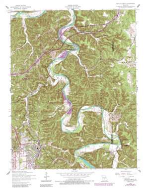
Devils Elbow Topo Map Missouri
To zoom in, hover over the map of Devils Elbow
USGS Topo Quad 37092g1 - 1:24,000 scale
| Topo Map Name: | Devils Elbow |
| USGS Topo Quad ID: | 37092g1 |
| Print Size: | ca. 21 1/4" wide x 27" high |
| Southeast Coordinates: | 37.75° N latitude / 92° W longitude |
| Map Center Coordinates: | 37.8125° N latitude / 92.0625° W longitude |
| U.S. State: | MO |
| Filename: | o37092g1.jpg |
| Download Map JPG Image: | Devils Elbow topo map 1:24,000 scale |
| Map Type: | Topographic |
| Topo Series: | 7.5´ |
| Map Scale: | 1:24,000 |
| Source of Map Images: | United States Geological Survey (USGS) |
| Alternate Map Versions: |
Devils Elbow MO 1954, updated 1959 Download PDF Buy paper map Devils Elbow MO 1954, updated 1972 Download PDF Buy paper map Devils Elbow MO 1954, updated 1977 Download PDF Buy paper map Devils Elbow MO 1954, updated 1985 Download PDF Buy paper map Devils Elbow MO 1954, updated 1985 Download PDF Buy paper map Devils Elbow MO 1976, updated 1980 Download PDF Buy paper map Devils Elbow MO 2004, updated 2006 Download PDF Buy paper map Devils Elbow MO 2012 Download PDF Buy paper map Devils Elbow MO 2015 Download PDF Buy paper map |
| FStopo: | US Forest Service topo Devils Elbow is available: Download FStopo PDF Download FStopo TIF |
1:24,000 Topo Quads surrounding Devils Elbow
> Back to 37092e1 at 1:100,000 scale
> Back to 37092a1 at 1:250,000 scale
> Back to U.S. Topo Maps home
Devils Elbow topo map: Gazetteer
Devils Elbow: Capes
Deckers Point elevation 290m 951′Devils Elbow: Cliffs
Spring Creek Bluff elevation 286m 938′Devils Elbow: Parks
Fort Leonard Wood State Wildlife Management Area elevation 314m 1030′Devils Elbow: Populated Places
Devils Elbow elevation 228m 748′Hooker elevation 215m 705′
Morgan Heights elevation 298m 977′
Mossy Resort (historical) elevation 229m 751′
Munger Resort (historical) elevation 238m 780′
Spring Creek elevation 237m 777′
Devils Elbow: Ridges
Deckers Ridge elevation 320m 1049′Devils Elbow: Springs
Mossy Spring elevation 223m 731′Ousley Spring elevation 225m 738′
Shanghai Spring elevation 221m 725′
Devils Elbow: Streams
Dry Creek elevation 218m 715′Spring Creek elevation 228m 748′
Devils Elbow: Summits
Lost Hill elevation 241m 790′Devils Elbow: Valleys
Hooker Hollow elevation 235m 770′Round Pond Hollow elevation 255m 836′
Smoky Hollow elevation 229m 751′
Strawstack Hollow elevation 232m 761′
Ware Hollow elevation 239m 784′
Weeks Hollow elevation 213m 698′
Devils Elbow digital topo map on disk
Buy this Devils Elbow topo map showing relief, roads, GPS coordinates and other geographical features, as a high-resolution digital map file on DVD:


