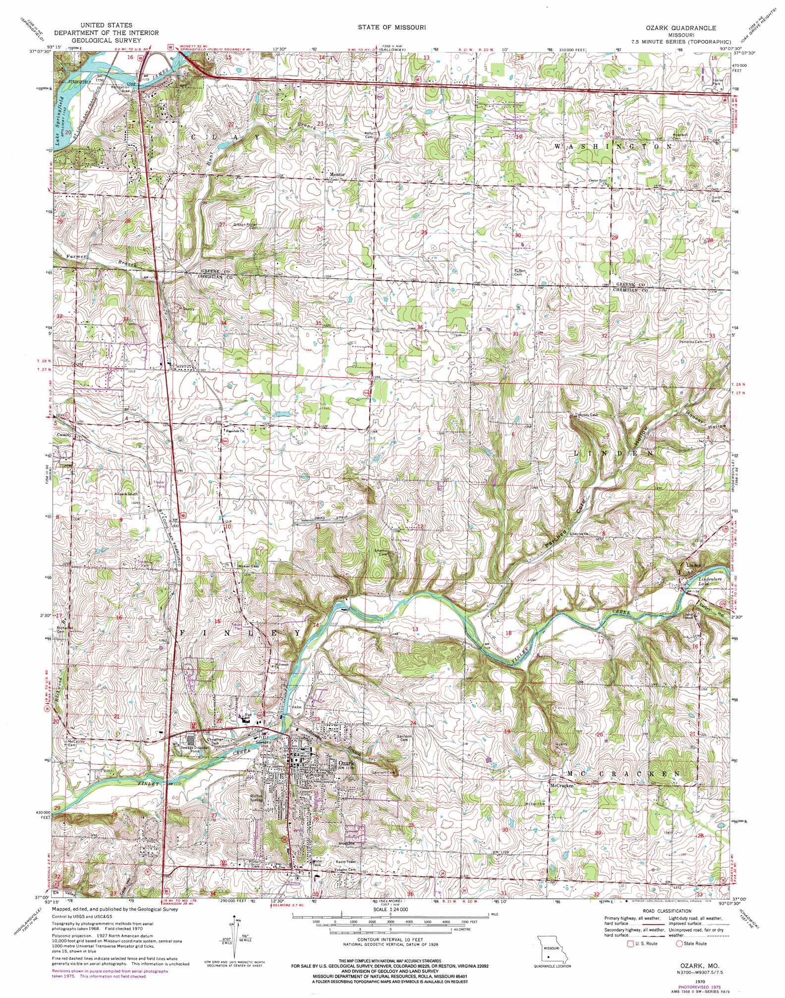
Ozark Topo Map Missouri
To zoom in, hover over the map of Ozark
USGS Topo Quad 37093a2 - 1:24,000 scale
| Topo Map Name: | Ozark |
| USGS Topo Quad ID: | 37093a2 |
| Print Size: | ca. 21 1/4" wide x 27" high |
| Southeast Coordinates: | 37° N latitude / 93.125° W longitude |
| Map Center Coordinates: | 37.0625° N latitude / 93.1875° W longitude |
| U.S. State: | MO |
| Filename: | o37093a2.jpg |
| Download Map JPG Image: | Ozark topo map 1:24,000 scale |
| Map Type: | Topographic |
| Topo Series: | 7.5´ |
| Map Scale: | 1:24,000 |
| Source of Map Images: | United States Geological Survey (USGS) |
| Alternate Map Versions: |
Ozark MO 1970, updated 1971 Download PDF Buy paper map Ozark MO 1970, updated 1976 Download PDF Buy paper map Ozark MO 1970, updated 1976 Download PDF Buy paper map Ozark MO 1979, updated 1981 Download PDF Buy paper map Ozark MO 2011 Download PDF Buy paper map Ozark MO 2015 Download PDF Buy paper map |
1:24,000 Topo Quads surrounding Ozark
Willard |
Ebenezer |
Bassville |
Strafford |
Marshfield |
Brookline |
Springfield |
Galloway |
Oak Grove Heights |
Fordland |
Republic |
Nixa |
Ozark |
Rogersville |
Bruner |
Hurley |
Highlandville |
Selmore |
Chadwick |
Keltner |
Galena |
Spokane |
Day |
Garrison |
Bradleyville |
> Back to 37093a1 at 1:100,000 scale
> Back to 37092a1 at 1:250,000 scale
> Back to U.S. Topo Maps home
Ozark topo map: Gazetteer
Ozark: Airports
Air Park South elevation 402m 1318′Sadowski Private Airport elevation 383m 1256′
Ozark: Populated Places
Cassidy elevation 386m 1266′Cowan elevation 420m 1377′
Fremont Hills elevation 392m 1286′
Linden elevation 352m 1154′
McCracken elevation 421m 1381′
Mentor elevation 410m 1345′
Ozark elevation 356m 1167′
Palace (historical) elevation 419m 1374′
Pembina elevation 430m 1410′
Ozark: Reservoirs
Lindenlure Lake elevation 347m 1138′Ozark: Springs
Melton Spring elevation 352m 1154′Ozark: Streams
Garrison Branch elevation 338m 1108′Hunt Branch elevation 363m 1190′
Parched Corn Creek elevation 340m 1115′
Richwood Branch elevation 329m 1079′
Thompson Creek elevation 351m 1151′
Ozark: Valleys
Carter Hollow elevation 349m 1145′Mooney Hollow elevation 381m 1250′
Parched Corn Hollow elevation 341m 1118′
Ozark digital topo map on disk
Buy this Ozark topo map showing relief, roads, GPS coordinates and other geographical features, as a high-resolution digital map file on DVD: