Oak Grove Heights Topo Map Missouri
To zoom in, hover over the map of Oak Grove Heights
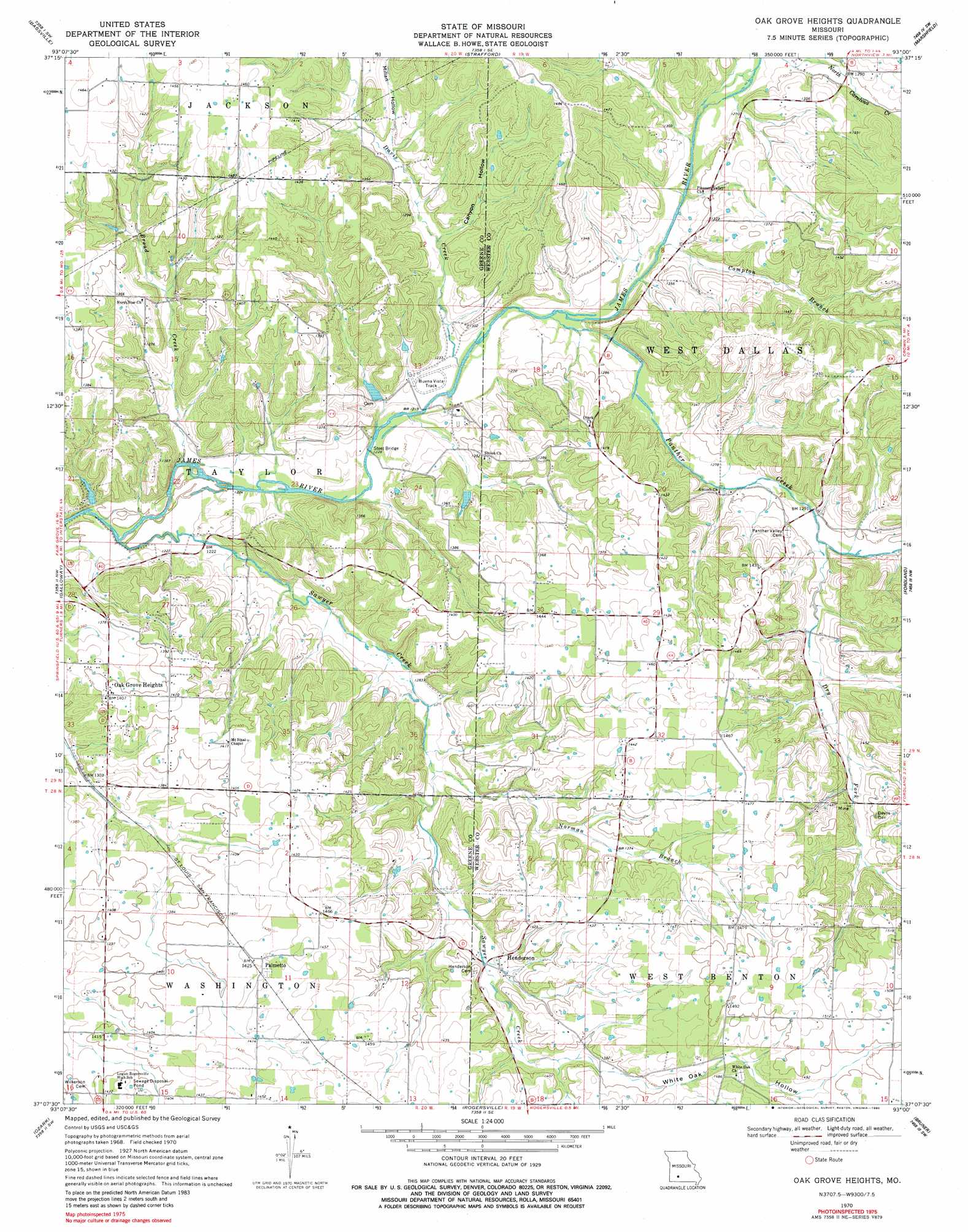
USGS Topo Quad 37093b1 - 1:24,000 scale
| Topo Map Name: | Oak Grove Heights |
| USGS Topo Quad ID: | 37093b1 |
| Print Size: | ca. 21 1/4" wide x 27" high |
| Southeast Coordinates: | 37.125° N latitude / 93° W longitude |
| Map Center Coordinates: | 37.1875° N latitude / 93.0625° W longitude |
| U.S. State: | MO |
| Filename: | o37093b1.jpg |
| Download Map JPG Image: | Oak Grove Heights topo map 1:24,000 scale |
| Map Type: | Topographic |
| Topo Series: | 7.5´ |
| Map Scale: | 1:24,000 |
| Source of Map Images: | United States Geological Survey (USGS) |
| Alternate Map Versions: |
Oak Grove Heights MO 1970, updated 1971 Download PDF Buy paper map Oak Grove Heights MO 1970, updated 1980 Download PDF Buy paper map Oak Grove Heights MO 2011 Download PDF Buy paper map Oak Grove Heights MO 2015 Download PDF Buy paper map |
1:24,000 Topo Quads surrounding Oak Grove Heights
Pleasant Hope |
Fair Grove |
Elkland |
Beach |
Niangua |
Ebenezer |
Bassville |
Strafford |
Marshfield |
High Prarie |
Springfield |
Galloway |
Oak Grove Heights |
Fordland |
Seymour |
Nixa |
Ozark |
Rogersville |
Bruner |
Dogwood |
Highlandville |
Selmore |
Chadwick |
Keltner |
Goodhope |
> Back to 37093a1 at 1:100,000 scale
> Back to 37092a1 at 1:250,000 scale
> Back to U.S. Topo Maps home
Oak Grove Heights topo map: Gazetteer
Oak Grove Heights: Basins
Devils Den elevation 422m 1384′Oak Grove Heights: Bridges
Steel Bridge elevation 372m 1220′Oak Grove Heights: Dams
Barnard Lake Dam elevation 376m 1233′Lake James Dam elevation 382m 1253′
Oak Grove Heights: Populated Places
All elevation 444m 1456′Compton (historical) elevation 398m 1305′
Henderson elevation 408m 1338′
Lon elevation 429m 1407′
Oak Grove Heights elevation 429m 1407′
Palmetto elevation 438m 1437′
Panther Valley elevation 416m 1364′
Oak Grove Heights: Post Offices
All Post Office elevation 444m 1456′Oak Grove Heights: Reservoirs
Barnard Lake elevation 376m 1233′Lake James elevation 382m 1253′
Oak Grove Heights: Streams
Broad Creek elevation 365m 1197′Compton Branch elevation 378m 1240′
Davis Creek elevation 372m 1220′
Dry Fork elevation 390m 1279′
Norman Branch elevation 388m 1272′
Panther Creek elevation 373m 1223′
Sayers Creek elevation 364m 1194′
Oak Grove Heights: Valleys
Canyon Hollow elevation 389m 1276′Millan Hollow elevation 398m 1305′
White Oak Hollow elevation 416m 1364′
Oak Grove Heights digital topo map on disk
Buy this Oak Grove Heights topo map showing relief, roads, GPS coordinates and other geographical features, as a high-resolution digital map file on DVD: